

Selma, North Carolina
Encyclopedia
Selma is a town in Johnston County
, North Carolina
, United States
. In 2007, the estimated population was 7,008. Selma is located in North Carolina's Inner Banks
region.
According to the United States Census Bureau
, the town has a total area of 3.2 square miles (8.3 km²), all of it land.
of 2000, there were 5,914 people, 2,254 households, and 1,480 families residing in the town. The population density
was 1,830.6 people per square mile (706.9/km²). There were 2,515 housing units at an average density of 778.5 per square mile (300.6/km²). The racial makeup of the town was 47.09% White, 40.33% Black, 0.57% Indian, 0.19% Asian, 0.08% Pacific Islander, 9.89% from other races
, and 1.84% from two or more races. Hispanics or Latinos of any race were 19.02% of the population.
There were 2,254 households out of which 31.9% had children under the age of 18 living with them, 38.1% were married couples
living together, 21.3% had a female householder with no husband present, and 34.3% were non-families. 28.7% of all households were made up of individuals and 11.8% had someone living alone who was 65 years of age or older. The average household size was 2.61 and the average family size was 3.17.
In the town the population was spread out with 27.9% under the age of 18, 11.6% from 18 to 24, 28.6% from 25 to 44, 20.4% from 45 to 64, and 11.5% who were 65 years of age or older. The median age was 31 years. For every 100 females there were 94.2 males. For every 100 females age 18 and over, there were 88.8 males.
The median income for a household in the town was $23,856 and the median income for a family was $32,430. Males had a median income of $26,886 versus $21,453 for females. The per capita income
for the town was $12,101. About 23.1% of families and 30.0% of the population were below the poverty line, including 45.9% of those under age 18 and 22.1% of those age 65 or over.
 On May 1, 1867, lots were sold around a newly established station on the North Carolina Railroad
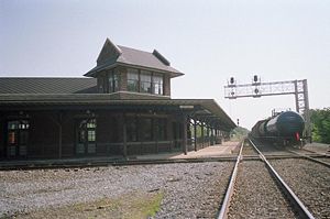
. From those lots, the town was built and considered a railroad town for many decades. Selma was officially chartered as a town on February 11, 1873. The town recently renovated its 1924 passenger depot
, which has Amtrak
service. The town is also home to the Mitchener Station, which was built in 1855 and thought to be the oldest surviving train station in North Carolina.http://www.selma-nc.com/ After Interstate 95
was built in the late 1950s, the town experienced growth due to its location next to the interstate. Today, there are many hotels and restaurants located in the area thanks to the traffic from I-95.
Johnston County, North Carolina
-Major highways:* Interstate 40* Interstate 95* U.S. Highway 70* U.S. Highway 301* U.S. Highway 701-Demographics:As of the census of 2000, there were 121,965 people, 46,595 households, and 33,688 families residing in the county. The population density was 154 people per square mile . There were...
, North Carolina
North Carolina
North Carolina is a state located in the southeastern United States. The state borders South Carolina and Georgia to the south, Tennessee to the west and Virginia to the north. North Carolina contains 100 counties. Its capital is Raleigh, and its largest city is Charlotte...
, United States
United States
The United States of America is a federal constitutional republic comprising fifty states and a federal district...
. In 2007, the estimated population was 7,008. Selma is located in North Carolina's Inner Banks
Inner Banks
The Inner Banks is a term used by some to describe the inland coastal region of eastern North Carolina, an area on the East Coast of the United States that is 22,227 square-miles by its broadest definition...
region.
Geography
Selma is located at 35°32′13"N 78°17′5"W (35.536982, -78.284642).According to the United States Census Bureau
United States Census Bureau
The United States Census Bureau is the government agency that is responsible for the United States Census. It also gathers other national demographic and economic data...
, the town has a total area of 3.2 square miles (8.3 km²), all of it land.
Demographics
As of the censusCensus
A census is the procedure of systematically acquiring and recording information about the members of a given population. It is a regularly occurring and official count of a particular population. The term is used mostly in connection with national population and housing censuses; other common...
of 2000, there were 5,914 people, 2,254 households, and 1,480 families residing in the town. The population density
Population density
Population density is a measurement of population per unit area or unit volume. It is frequently applied to living organisms, and particularly to humans...
was 1,830.6 people per square mile (706.9/km²). There were 2,515 housing units at an average density of 778.5 per square mile (300.6/km²). The racial makeup of the town was 47.09% White, 40.33% Black, 0.57% Indian, 0.19% Asian, 0.08% Pacific Islander, 9.89% from other races
Race (United States Census)
Race and ethnicity in the United States Census, as defined by the Federal Office of Management and Budget and the United States Census Bureau, are self-identification data items in which residents choose the race or races with which they most closely identify, and indicate whether or not they are...
, and 1.84% from two or more races. Hispanics or Latinos of any race were 19.02% of the population.
There were 2,254 households out of which 31.9% had children under the age of 18 living with them, 38.1% were married couples
Marriage
Marriage is a social union or legal contract between people that creates kinship. It is an institution in which interpersonal relationships, usually intimate and sexual, are acknowledged in a variety of ways, depending on the culture or subculture in which it is found...
living together, 21.3% had a female householder with no husband present, and 34.3% were non-families. 28.7% of all households were made up of individuals and 11.8% had someone living alone who was 65 years of age or older. The average household size was 2.61 and the average family size was 3.17.
In the town the population was spread out with 27.9% under the age of 18, 11.6% from 18 to 24, 28.6% from 25 to 44, 20.4% from 45 to 64, and 11.5% who were 65 years of age or older. The median age was 31 years. For every 100 females there were 94.2 males. For every 100 females age 18 and over, there were 88.8 males.
The median income for a household in the town was $23,856 and the median income for a family was $32,430. Males had a median income of $26,886 versus $21,453 for females. The per capita income
Per capita income
Per capita income or income per person is a measure of mean income within an economic aggregate, such as a country or city. It is calculated by taking a measure of all sources of income in the aggregate and dividing it by the total population...
for the town was $12,101. About 23.1% of families and 30.0% of the population were below the poverty line, including 45.9% of those under age 18 and 22.1% of those age 65 or over.
History
North Carolina Railroad
The North Carolina Railroad is a state-owned rail corridor extending from Morehead City, North Carolina to Charlotte, North Carolina. The railroad carries over seventy freight trains and eight passenger trains daily...
. From those lots, the town was built and considered a railroad town for many decades. Selma was officially chartered as a town on February 11, 1873. The town recently renovated its 1924 passenger depot
Selma-Smithfield (Amtrak station)
The Selma–Smithfield Amtrak Station, located in Selma, North Carolina, was previously known as the Selma Union Depot and is served by two Amtrak passenger trains, the Palmetto and Carolinian. The street address is 500 East Railroad Street, and is located in the heart of historic downtown Selma...
, which has Amtrak
Amtrak
The National Railroad Passenger Corporation, doing business as Amtrak , is a government-owned corporation that was organized on May 1, 1971, to provide intercity passenger train service in the United States. "Amtrak" is a portmanteau of the words "America" and "track". It is headquartered at Union...
service. The town is also home to the Mitchener Station, which was built in 1855 and thought to be the oldest surviving train station in North Carolina.http://www.selma-nc.com/ After Interstate 95
Interstate 95 in North Carolina
Interstate 95 is a major Interstate Highway, running along the East Coast of the United States from Florida to Maine. In North Carolina, I-95 runs diagonally across the eastern third of the state, from Rowland in the southwest to Roanoke Rapids in the northeast of the Inner Banks.-Route...
was built in the late 1950s, the town experienced growth due to its location next to the interstate. Today, there are many hotels and restaurants located in the area thanks to the traffic from I-95.
Education
- Selma Elementary School
- Selma Middle School
- Neuse Charter School of Johnston County, Inc.
Notable residents
- Shelton Shepherd
- Lunsford Richardson: Founder of the Vick Chemical Company, maker of cold remedies such as Vick's Cough Drops