
Seaforth, New South Wales
Encyclopedia
Suburb
The word suburb mostly refers to a residential area, either existing as part of a city or as a separate residential community within commuting distance of a city . Some suburbs have a degree of administrative autonomy, and most have lower population density than inner city neighborhoods...
of northern Sydney
Sydney
Sydney is the most populous city in Australia and the state capital of New South Wales. Sydney is located on Australia's south-east coast of the Tasman Sea. As of June 2010, the greater metropolitan area had an approximate population of 4.6 million people...
, in the state of New South Wales
New South Wales
New South Wales is a state of :Australia, located in the east of the country. It is bordered by Queensland, Victoria and South Australia to the north, south and west respectively. To the east, the state is bordered by the Tasman Sea, which forms part of the Pacific Ocean. New South Wales...
, Australia
Australia
Australia , officially the Commonwealth of Australia, is a country in the Southern Hemisphere comprising the mainland of the Australian continent, the island of Tasmania, and numerous smaller islands in the Indian and Pacific Oceans. It is the world's sixth-largest country by total area...
. Seaforth is located 12 kilometres north-east of the Sydney central business district
Sydney central business district
The Sydney central business district is the main commercial centre of Sydney, New South Wales, Australia. It extends southwards for about 3 kilometres from Sydney Cove, the point of first European settlement. Its north–south axis runs from Circular Quay in the north to Central railway station in...
in the local government area of Manly Council
Manly Council
Manly Council is a Local Government Area on the Northern Beaches of Sydney, in the state of New South Wales, Australia.- Demographics :According to the , there:...
and is part of the Northern Beaches region.
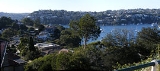
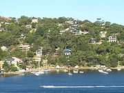
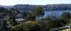
Seaforth overlooks Middle Harbour
Middle Harbour
Middle Harbour is the northern arm of Port Jackson in Sydney, Australia.Middle Harbour extends about to the northwest, from where it joins the main harbour near the Heads. Its shore is nearly everywhere rugged, barren and forested and for this reason Middle Harbour was almost entirely neglected...
and is linked south to Mosman
Mosman, New South Wales
Mosman is a suburb on the Lower North Shore of Sydney, in the state of New South Wales, Australia. Mosman is located 8 kilometres north-east of the Sydney central business district and is the administrative centre for the local government area of the Municipality of Mosman.-Localities:In February...
by the Spit Bridge
Spit Bridge
The Spit Bridge is a bascule bridge that carries Spit Road over Middle Harbour in Sydney, New South Wales, Australia, at a point called "The Spit", 10 km north-east of the CBD. It connects the suburbs of Mosman, on the south bank and Seaforth, on the north bank...
. To the west, Seaforth overlooks Sugarloaf Bay across to the suburbs of Northbridge
Northbridge, New South Wales
Northbridge is a suburb on the lower North Shore of Sydney, New South Wales, Australia. Northbridge is located 7 kilometres north of the Sydney central business district, in the local government area of Willoughby....
, Castlecrag
Castlecrag, New South Wales
Castlecrag is a suburb on the lower North Shore of Sydney, in the state of New South Wales, Australia. Castlecrag is located 8 kilometres north of the Sydney central business district, in the local government area of the City of Willoughby....
and Castle Cove
Castle Cove, New South Wales
Castle Cove is a suburb on the lower North Shore of Sydney, in the state of New South Wales, Australia. Castle Cove is located 11 kilometres north of the Sydney central business district, in the local government area of the City of Willoughby...
. The Garigal National Park
Garigal National Park
Garigal National Park is a national park in New South Wales , 20 km north of central Sydney. The park is somewhat disjointed but covers the following areas:...
sits on the northern border.
History
Seaforth was named after Loch SeaforthLoch Seaforth
Loch Seaforth is sea loch in the Outer Hebrides of Scotland. It forms the boundary between Lewis and Harris and formerly was the boundary between the traditional counties of Ross and Cromarty and Inverness-shire....
and Seaforth Island
Seaforth Island
Seaforth Island is an uninhabited island in the Outer Hebrides of Scotland. Unlike other islands of the Outer Hebrides which are mainly surrounded by open sea, Seaforth Island lies in a narrow fjord-like sea loch named Loch Seaforth, from the open waters of the Minch...
in Scotland
Scotland
Scotland is a country that is part of the United Kingdom. Occupying the northern third of the island of Great Britain, it shares a border with England to the south and is bounded by the North Sea to the east, the Atlantic Ocean to the north and west, and the North Channel and Irish Sea to the...
. The land in this area was once owned by Henry Halloran
Henry Halloran
Henry Ferdinand Halloran was a major property owner and developer in New South Wales in the early part of the twentieth Century. He was born in Sydney on 9 August 1869. His father was a bank clerk and architect named Edward Roland Halloran and mother was Adeline Burgess, née Reuss...
, who subdivided it in 1906.
The Seaforth library was built in 1887 and protected by heritage listing by Manly Council in 1995. It stands outside the former Seaforth TAFE. Seaforth celebrated its centenary on Sunday 12 November 2006 with a historical display in the town centre.