

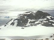
Sea Lion Glacier
Encyclopedia
Hurd Peninsula
Hurd Peninsula is the land between South Bay and False Bay on the south coast of Livingston Island in the South Shetland Islands, Antarctica. The Spanish Antarctic base Juan Carlos I and the Bulgarian Antarctic base St. Kliment Ohridski are situated on the west coast of the peninsula.The feature...
, eastern Livingston Island in the South Shetland Islands
South Shetland Islands
The South Shetland Islands are a group of Antarctic islands, lying about north of the Antarctic Peninsula, with a total area of . By the Antarctic Treaty of 1959, the Islands' sovereignty is neither recognized nor disputed by the signatories and they are free for use by any signatory for...
, Antarctica. It is located southwest of Hesperides Hill
Hesperides Hill
Hesperides Hill is a ridge linked by a saddle of elevation 52 m with the northern slopes of Atlantic Club Ridge on Hurd Peninsula, eastern Livingston Island in the South Shetland Islands, Antarctica...
and northwest of Atlantic Club Ridge
Atlantic Club Ridge
The Atlantic Club Ridge is a ridge rising to 161 m on Hurd Peninsula in Eastern Livingston Island, Antarctica...
, separated from the latter by Sea Lion Tarn
Sea Lion Tarn
Sea Lion Tarn is a freshwater tarn with an area of located between Sea Lion Glacier and the north-western slopes of Atlantic Club Ridge on Hurd Peninsula in eastern Livingston Island in the South Shetland Islands, Antarctica...
, and terminating on the South Bay
South Bay, Livingston Island
South Bay is a wide bay indenting for the south coast of Livingston Island in the South Shetland Islands, Antarctica. The bay is lying northwest of False Bay and east of Walker Bay, and is entered between Hannah Point and Miers Bluff....
coast.
The glacier, subject of glaciological
Glaciology
Glaciology Glaciology Glaciology (from Middle French dialect (Franco-Provençal): glace, "ice"; or Latin: glacies, "frost, ice"; and Greek: λόγος, logos, "speech" lit...
studies and monitoring for several years since 1993, disappeared completely within a decade.
Location
The midpoint is located at 62°38′46"S 60°22′12"W (Bulgarian mapping from a 1995–1996 ground survey).Maps
- L.L. Ivanov. Livingston Island: Central-Eastern Region. Scale 1:25000 topographic map. Sofia: Antarctic Place-names Commission of Bulgaria, 1996.
- L.L. Ivanov et al. Antarctica: Livingston Island and Greenwich Island, South Shetland Islands. Scale 1:100000 topographic map. Sofia: Antarctic Place-names Commission of Bulgaria, 2005.
- L.L. Ivanov. Antarctica: Livingston Island and Greenwich, Robert, Snow and Smith Islands. Scale 1:120000 topographic map. Troyan: Manfred Wörner Foundation, 2009. ISBN 978-954-92032-6-4