

Scarborough—Rouge River (provincial electoral district)
Encyclopedia
.png)
Electoral district (Canada)
An electoral district in Canada, also known as a constituency or a riding, is a geographical constituency upon which Canada's representative democracy is based...
in Ontario
Ontario
Ontario is a province of Canada, located in east-central Canada. It is Canada's most populous province and second largest in total area. It is home to the nation's most populous city, Toronto, and the nation's capital, Ottawa....
, Canada
Canada
Canada is a North American country consisting of ten provinces and three territories. Located in the northern part of the continent, it extends from the Atlantic Ocean in the east to the Pacific Ocean in the west, and northward into the Arctic Ocean...
, that has been represented in the Legislative Assembly of Ontario
Legislative Assembly of Ontario
The Legislative Assembly of Ontario , is the legislature of the Canadian province of Ontario, and is the second largest provincial legislature of Canada...
since 1999.
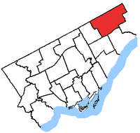
The riding
Electoral district (Canada)
An electoral district in Canada, also known as a constituency or a riding, is a geographical constituency upon which Canada's representative democracy is based...
covers the northeast part of the Scarborough
Scarborough, Ontario
Scarborough is a dissolved municipality within the city of Toronto, Ontario, Canada. Geographically, it comprises the eastern part of Toronto. It is bordered on the south by Lake Ontario, on the west by Victoria Park Avenue, on the north by Steeles Avenue East, and on the east by the Rouge River...
part of Toronto. It stretches from Highway 401
Highway 401 (Ontario)
King's Highway 401, also known by its official name as the Macdonald–Cartier Freeway and colloquially as the four-oh-one, is a 400-Series Highway in the Canadian province of Ontario stretching from Windsor to the Quebec border...
in the south to Steeles Avenue
Steeles Avenue
Steeles Avenue is an east-west street that forms the northern city limit of Toronto and the southern limit of York Region, Ontario, Canada. It stretches across the western Greater Toronto Area from Milborough Townline in Halton Region east to the Scarborough-Pickering limit. It runs for within...
in the north. In the east it ends at the border with Pickering
Pickering, Ontario
Pickering is a city located in Southern Ontario, Canada immediately east of Toronto in Durham Region. It is part of the Greater Toronto Area, the largest metropolitan area in Canada.- Early Period :...
and to just west of Midland in the west.
13.6% of the population is Hindu, the highest in Canada.
Geography
Scarborough—Rouge River consists of the part of the City of Toronto bounded on the north and east by the city limits, on the west by Midland Avenue, and on the south by a line drawn from the east city limit west along Finch Avenue East, south along Meadowvale Road, west along Sheppard Avenue East, south along Morningside Avenue, west along Highway 401, north along Brimley Road, and west along Finch Avenue East to Midland Avenue.The provincial electoral district was created in 1999 when provincial ridings were defined to have the same borders as federal ridings.
Members of Provincial Parliament
Election results
Note: the 2011 election was held on October 6, 2011.
** Preliminary Results - Not Official Yet. **
2007 electoral reform referendum
| Ontario electoral reform referendum, 2007 Ontario electoral reform referendum, 2007 An Ontario electoral reform referendum was held on October 10, 2007, in an attempt to establish a mixed member proportional representation system for elections to the Legislative Assembly of Ontario... |
|||
|---|---|---|---|
| Side | Votes | % | |
| First Past the Post | 18,271 | 55.2 | |
| Mixed member proportional | 14,856 | 44.8 | |
| Total valid votes | 33,127 | 100.0 | |