
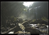
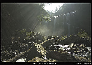
Sathodi Falls
Encyclopedia
India
India , officially the Republic of India , is a country in South Asia. It is the seventh-largest country by geographical area, the second-most populous country with over 1.2 billion people, and the most populous democracy in the world...
that is formed by several unnamed streams near Kallaramarane Ghat, Uttara Kannada District, near Sirsi
Sirsi
-Geography:Sirsi is located at . It has an average elevation of 590 metres , and is situated in the heart of the Western Ghats. Sirsi is about 425 km from Bangalore. The nearest airport is located in Hubli, about 102 km from Sirsi....
, and 32 km from Yellapur. It is about 15 meters (49.2 feet) tall. The stream then flows into the backwaters of the Kodasalli Dam
Kodasalli Dam
Kodasalli Dam is built across the Kali River in Yallapura taluk of Uttara Kannada district of Karnataka state, India. This dam was built by Karnataka Power Corporation Limited. This electric power generating station is classified as hydroelectric power station.-External links:**...
, into the Kali River
Kali River (Karnataka)
The Kali River or Kalinadi is a river flowing through Karwar, Uttara Kannada district Karnataka state in India. The river takes its birth in Diggi, a small village in Uttar Kannada district...
. The forest department was building a pergola for tourists to rest as of December 2006.
Season
It is best to visit the falls in winter, from early November to the end of march. Avoid the rainy season, when hostile terrain and blood-sucking leeches and slippery rocks make these falls inaccessible.Food
There is only one hotel near the waterfalls which opens around 9AM and closes at 5.30PM. so you should order in advance to get food early enough. It is better to fill yourself at Yellapur and carry sufficient food and water.sathodi view.jpeg/sathodi-falls.jpeg
Access
From Yellapur, take the highway towards Hubballi (Hubli) [opposite direction of Magod FallsMagod Falls
Magod Falls is a group of waterfalls in Karnataka, India, where the river Bedti falls from a height of nearly 200m in two steps.-See also:* List of waterfalls in India* List of waterfalls in India by height...
] and then turn left towards Ganesh Gudi (do not confuse this for Ganesh Gudi near Dandeli) immediately after the petrol bunk. An arch [Mysore Minerals] at the beginning of this road is a good landmark for the road to Sathodi Falls. The total distance from the arc to the falls is about 25 km with a mix of good and bad roads. Part of the distance is more like a trail and littered with small stones and rocks, however there is no risk of puncture here due to the rocks.
The roads are all right, with both good and bad patches. The distance between Ganesh Gudi and Sathodi Falls is around 10 kilometers. After Ganesh Gudi, it is just forest and forest and then comes to the beautiful view of the backwaters of the Kodasalli dam built across the river Kali.
The roads are very risky with steep hills go beside backwater. It is a trekking place.
Vehicles can go up to hotel from there u need to go by walk nearly 1km. or else you can trek for 5 to 6km in Kaccha road to falls, from the bank you get spectacular view of backwater.
One can ride right up to the falls and walk a distance of about 300mts to reach the falls, there are boulders one has to jump to access the waterfalls.
Alternate routes
- Take a bus up to Barballi, and from there it is trek of about 10 km.
- Go up to Dehalli - Kattige via Ganesh Gudi, wherein a kuchcha road winds all the way to the falls. Bikes are also available for rent at Dehalli, which are a common means of transport in this region.
Caution
As the Western Ghats waterfalls are more powerful during rainy seasons,due to heavy rain its becomes more difficult for vehicular movement. And don't step into backwaters as there is news of crocodiles. But we can swim in front of the falls.beware of snakes.See also
RANEBENNUR TO SATHODI FALLS GOING ROAD DETAIL'S
RANEBENNUR TO HAVERI = 32 K.M
HAVERI TO BANKAPUR = 24 K.M
BANKARPUR TO MUNDAGOD = 30 K.M
MUNDOGOD TO YELLAPUR = 40 K.M
YELLAPUR TO SATHODI FALLS = 27 K.M
FROM : MANJUNATHA RANEBENNUR
DEO