

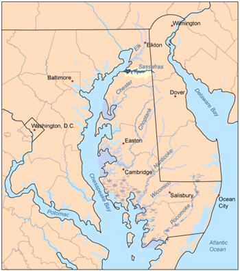
Sassafras River
Encyclopedia
Tributary
A tributary or affluent is a stream or river that flows into a main stem river or a lake. A tributary does not flow directly into a sea or ocean...
of the Chesapeake Bay
Chesapeake Bay
The Chesapeake Bay is the largest estuary in the United States. It lies off the Atlantic Ocean, surrounded by Maryland and Virginia. The Chesapeake Bay's drainage basin covers in the District of Columbia and parts of six states: New York, Pennsylvania, Delaware, Maryland, Virginia, and West...
on the Delmarva Peninsula
Delmarva Peninsula
The Delmarva Peninsula is a large peninsula on the East Coast of the United States, occupied by most of Delaware and portions of Maryland and Virginia...
in the United States
United States
The United States of America is a federal constitutional republic comprising fifty states and a federal district...
. It is about 22 miles (35.4 km) long and starts in western New Castle County
New Castle County, Delaware
New Castle County is the northernmost of the three counties of the U.S. state of Delaware. As of 2010 its population was 538,479, an increase of 7.6% over the previous decade. The county seat is Wilmington. The center of population of Delaware is located in New Castle County, in the town of...
, Delaware
Delaware
Delaware is a U.S. state located on the Atlantic Coast in the Mid-Atlantic region of the United States. It is bordered to the south and west by Maryland, and to the north by Pennsylvania...
, and along the boundary between Cecil County
Cecil County, Maryland
Cecil County is a county located in the U.S. state of Maryland. It is part of the Delaware Valley. It was named for Cæcilius Calvert, 2nd Baron Baltimore , who was the first Proprietary Governor of the colony of Maryland from 1632 until his death in 1675. The county seat is Elkton. The newspaper...
, Maryland
Maryland
Maryland is a U.S. state located in the Mid Atlantic region of the United States, bordering Virginia, West Virginia, and the District of Columbia to its south and west; Pennsylvania to its north; and Delaware to its east...
on the north and Kent County
Kent County, Maryland
Kent County is a county located in the U.S. state of Maryland, on its Eastern Shore. It was named for the county of Kent in England. Its county seat is Chestertown. In 2010, the county population was 20,197...
, Maryland
Maryland
Maryland is a U.S. state located in the Mid Atlantic region of the United States, bordering Virginia, West Virginia, and the District of Columbia to its south and west; Pennsylvania to its north; and Delaware to its east...
on the south. It rises southwest of Middletown
Middletown, Delaware
Middletown is a town in New Castle County, Delaware, United States. According to the 2010 Census, the population of the town is 18,871.-Geography:Middletown is located at with an elevation of ....
, Delaware
Delaware
Delaware is a U.S. state located on the Atlantic Coast in the Mid-Atlantic region of the United States. It is bordered to the south and west by Maryland, and to the north by Pennsylvania...
and ends at the Chesapeake Bay
Chesapeake Bay
The Chesapeake Bay is the largest estuary in the United States. It lies off the Atlantic Ocean, surrounded by Maryland and Virginia. The Chesapeake Bay's drainage basin covers in the District of Columbia and parts of six states: New York, Pennsylvania, Delaware, Maryland, Virginia, and West...
in a wide mouth between Howell Point near Betterton
Betterton, Maryland
Betterton is a town in Kent County, Maryland, United States. The population was 376 at the 2000 census.-Betterton Historic District:The Betterton Historic District consists of a collection of vernacular Victorian resort structures. The district includes many of the homes, hotels and cottages built...
, Maryland
Maryland
Maryland is a U.S. state located in the Mid Atlantic region of the United States, bordering Virginia, West Virginia, and the District of Columbia to its south and west; Pennsylvania to its north; and Delaware to its east...
and Grove Point on Grove Neck.
It is south of the Elk River
Elk River (Maryland)
The Elk River is a tributary of the Chesapeake Bay on the Delmarva Peninsula. It is about long, and as the most northeastern extension of the Chesapeake Bay estuary, serves as one entrance to the Chesapeake and Delaware Canal. It is located in Cecil County, Maryland, with its headwaters extending...
and north of the Chester River
Chester River
The Chester River is a major tributary of the Chesapeake Bay on the Delmarva Peninsula. It is about long, and its watershed encompasses , which includes of land. Thus the total watershed area is 20% water. It forms the border between Kent County and Queen Anne's County, Maryland, with its...
. The Sassafras River is entirely within the coastal plain. Its watershed area (including the water surface) is 97 square miles (251.2 km²), with 83 square miles (215 km²) of land. Thus, its total watershed area is 14% water.
There are several small creeks on the northern shore of the Sassafras River, including Money Creek, Cox Creek, Foreman Creek, Back Creek, McGill Creek, Dowdel Creek, Hall Creek, and Duffy Creek. On the southern shore small creeks include Lloyd Creek, Turner's Creek, Freeman Creek, Woodland Creek, Dyer Creek, Mill Creek, Swantown Creek, Jacobs Creek, and Herring Branch.
On the 1612 John Smith
John Smith of Jamestown
Captain John Smith Admiral of New England was an English soldier, explorer, and author. He was knighted for his services to Sigismund Bathory, Prince of Transylvania and friend Mózes Székely...
map of the area, it was called the Tockwogh River. A peninsula along the southern shore of the river containing several large farms and a large pond assembled into one property by the former owners of The Granary marina and restaurant at Georgetown, Liz Maytag and Mike Revuke, has been preserved as a wildlife sanctuary.
Boating
The channel, marked by buoy
Buoy
A buoy is a floating device that can have many different purposes. It can be anchored or allowed to drift. The word, of Old French or Middle Dutch origin, is now most commonly in UK English, although some orthoepists have traditionally prescribed the pronunciation...
s, is at least approximately 10 feet (3 m) deep from the Chesapeake Bay Shipping Channel
Channel (geography)
In physical geography, a channel is the physical confine of a river, slough or ocean strait consisting of a bed and banks.A channel is also the natural or human-made deeper course through a reef, sand bar, bay, or any shallow body of water...
to Greg Neck Marina, just east of Georgetown and the drawbridge for Maryland route 213. The deepest portion of the Sassafras is just about in the middle of the river, east of the number 5 buoy on the tip of Ordinary Point. There, the depth reaches more than 50 feet (15.2 m). Farther upriver, the river soon becomes too shallow for even the smallest runabout or PWC
PwC
PricewaterhouseCoopers is a global professional services firm headquartered in London, United Kingdom. It is the world's largest professional services firm measured by revenues and one of the "Big Four" accountancy firms....
(jet-ski). The water there is only suitable for kayaks or canoes.
Cabin cruiser
A cabin cruiser is a type of power boat that provides accommodation for its crew and passengers inside the structure of the craft.A cabin cruiser usually ranges in size from in length, with larger pleasure craft usually considered yachts. Many cabin cruisers can be recovered and towed with a...
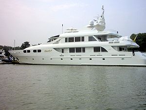
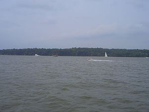
, sailboats of all kinds, and occasionally, one may spot a large motor yacht. Most of the boats come from the marinas, but there are a number that come from private piers, most of which are on the southern side of the river. There are a number of beaches along the river where boaters may anchor and swim, or they may choose to ski or tube in one of the river's many creeks and coves where wakes can be avoided as much as possible.
Most of the piers along the river are fixed, as opposed to floating, with the exception of some of the marinas. This is because of the wakes, which can reach 2 foot (0.6096 m) on a busy day. The marinas are protected to a certain degree because of the no wake zone (where boats may not exceed 5 mph), with the exception of Gregg Neck Boat Yard which extends from buoy 12 to just east of the 213 drawbridge
Drawbridge
A drawbridge is a type of movable bridge typically associated with the entrance of a castle surrounded by a moat. The term is often used to describe all different types of movable bridges, like bascule bridges and lift bridges.-Castle drawbridges:...
. Also, some of the boat owners along the river who have private piers have decided to install boat lifts to lift their boats out of the water and away from the wakes.
External links
- Sassafras River Association
- Maryland DNR's Surf Your Watershed: Sassafras River