
Santo Antônio da Barra
Encyclopedia
| Santo Antônio da Barra | |
|---|---|
| State | Goiás Goiás Goiás is a state of Brazil, located in the central part of the country. The name Goiás comes from the name of an indigenous community... |
| Area: | 451.5 km² |
| Population: | 4,134(IBGE 2007) |
| Population density | 9.15 inhab/km² |
| Urban population | 3,401 |
| Rural population | 733 |
| Elevation: | 650m |
| Postcode (CEP): | 75935-000 |
| IBGE statistical microregion: | 018 Sudoeste de Goiás |
| Became a city: | 1992 |
| Mayor: | Osvaldo Fonseca de Almeida |
| Distance to Goiânia Goiânia -Climate:The city has a tropical wet and dry climate with an average temperature of . There's a wet season, from October to April, and a dry one, from May to September. Annual rainfall is around 1,520 mm.... : |
190 km. |
| Website: | n/a |
Municipality
A municipality is essentially an urban administrative division having corporate status and usually powers of self-government. It can also be used to mean the governing body of a municipality. A municipality is a general-purpose administrative subdivision, as opposed to a special-purpose district...
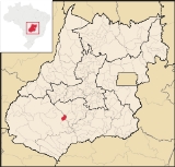
in southwest Goiás
Goiás
Goiás is a state of Brazil, located in the central part of the country. The name Goiás comes from the name of an indigenous community...
state, Brazil
Brazil
Brazil , officially the Federative Republic of Brazil , is the largest country in South America. It is the world's fifth largest country, both by geographical area and by population with over 192 million people...
. The population was 4,544 (2005 estimate) in a total area of 451.6 km². The elevation of the municipal seat is 650 meters. Santo Antônio is a large producer of poultry.
Location
Santo Antônio is 190 kilometers from the state capital, GoiâniaGoiânia
-Climate:The city has a tropical wet and dry climate with an average temperature of . There's a wet season, from October to April, and a dry one, from May to September. Annual rainfall is around 1,520 mm....
and is part of the Sudoeste de Goiás Microregion. The highway connection from Goiânia
Goiânia
-Climate:The city has a tropical wet and dry climate with an average temperature of . There's a wet season, from October to April, and a dry one, from May to September. Annual rainfall is around 1,520 mm....
is BR-060
BR-060
BR-060 is a federal highway of Brazil. The 1459 kilometre road connects Brasilia to Bela Vista, on the Paraguayan border....
. It has boundaries with the following municipalities:
- north: ParaúnaParaúnaParaúna is a small town and municipality in southwestern Goiás state, Brazil. It has strange rock formations and is a large producer of cotton and soybeans.-Location:...
- south: Santa Helena de GoiásSanta Helena de GoiásSanta Helena de Goiás is a small city and municipality in southwestern Goiás state, Brazil. It is a large producer of corn, sugarcane, soybeans, and poultry.-Location:...
- east: AcreúnaAcreúnaAcreúna is a small city and municipality in western Goiás state, Brazil.-Location:Acreúna is located in the statistical micro-region of Vale do Rio dos Bois, southwest of the state capital, Goiânia, on BR-060, which links Goiânia with Rio Verde...
- west: Rio VerdeRio VerdeRio Verde can mean the following:-Brazil:* Rio Verde, Goiás* Lucas do Rio Verde* Conceição do Rio Verde* Rio Verde de Mato Grosso-Brazil:29 rivers including:* Verde River...
Geographical information
The climate is moist tropical with high night-time temperatures. The rainy season is from October to March and the dry season is from April to September. Because of the hot and dry climate, the main vegetation is sparse cerradoCerrado
The Cerrado, is a vast tropical savanna ecoregion of Brazil, particularly in the states of Gioas and Minas Gerais...
. In the valleys there are still forests with sucupira, aroeira, pindaíba and other species of trees.
Santo Antônio da Barra is bathed by a vast river network, formed by the Verdão, which separates the municipality from Acreúna
Acreúna
Acreúna is a small city and municipality in western Goiás state, Brazil.-Location:Acreúna is located in the statistical micro-region of Vale do Rio dos Bois, southwest of the state capital, Goiânia, on BR-060, which links Goiânia with Rio Verde...
and Paraúna
Paraúna
Paraúna is a small town and municipality in southwestern Goiás state, Brazil. It has strange rock formations and is a large producer of cotton and soybeans.-Location:...
; Verdinho, on the border with Rio Verde
Rio Verde
Rio Verde can mean the following:-Brazil:* Rio Verde, Goiás* Lucas do Rio Verde* Conceição do Rio Verde* Rio Verde de Mato Grosso-Brazil:29 rivers including:* Verde River...
; and Ribeirão Lage, which forms the boundary with Santa Helena de Goiás
Santa Helena de Goiás
Santa Helena de Goiás is a small city and municipality in southwestern Goiás state, Brazil. It is a large producer of corn, sugarcane, soybeans, and poultry.-Location:...
.
Electric energy is furnished by the Hidrelétrica de Cachoeira Dourada, on the Paranaíba
Paranaíba River
The Paranaíba River is a Brazilian river whose source lies in the state of Minas Gerais in the Mata da Corda mountains, municipality of Rio Paranaíba, at an altitude of 1,148 meters; on the other face of this mountain chain are the sources of the Abaeté river, tributary of the São Francisco River...
.
History
Occupation of the region began in 1951 when Joaquim Domingos da Silva and his wife Alventina Borges da Silva fixed a cross in devotion to Santo Antônio. In 1963 the settlement was elevated to the status of district of Rio VerdeRio Verde
Rio Verde can mean the following:-Brazil:* Rio Verde, Goiás* Lucas do Rio Verde* Conceição do Rio Verde* Rio Verde de Mato Grosso-Brazil:29 rivers including:* Verde River...
The first municipal school, Escola Municipal Antônio Gouvêia de Morais, was built in 1976 with the secondary school, Irmãos Messias da Costa, being built in 1983. Finally, after a plebiscite, the district was emancipated and became a municipality in 1992.
Political and Demographic Information
- Mayor: Osvaldo Fonseca de Almeida (January 2005)
- City council: 09
- Eligible voters: 3,735 (2007)
- Population growth: 0.29% from 2000 to 2007
Economic information
The economy is based on subsistence agriculture, cattle raising, services, public administration, and small transformation industries. IN 2006 there were 41 agricultural units with 9,219 hectares, of which 3,090 were planted in crops. About 150 persons were employed in agriculture. The largest employer in the town was public service with 385 persons in 2006.- Industrial units: 3 (2007)
- Commercial units: 35 (2007)
- Automobiles: 228 (2007)
- Cattle herd: 22,000 head (2006)
- Main crops: cotton, rice, coconuts, beans, manioc, corn, tomatoes, and soybeans.
Education (2006)and Health (2007)
- Schools: 5 with 1,367 students
- Higher education: none
- Adult literacy rate: 77.1% (2000) (national average was 86.4%)
- Hospitals: 0
- Hospital beds: 0
- Ambulatory clinics: 1
- Infant mortality rate: 9.92 (2000) (national average was 33.0.
Municipal Human Development Index
Human Development Index
The Human Development Index is a composite statistic used to rank countries by level of "human development" and separate "very high human development", "high human development", "medium human development", and "low human development" countries...
- MHDI: 0.746
- State ranking: 86 (out of 242 municipalities in 2000)
- National ranking: 1,984 (out of 5,507 municipalities in 2000)
Data are from 2000
For the complete list see Frigoletto.com
See also
- List of municipalities in Goiás
- Microregions of Goiás