

Santa Rosa da Serra
Encyclopedia
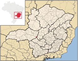
Minas Gerais
Minas Gerais is one of the 26 states of Brazil, of which it is the second most populous, the third richest, and the fourth largest in area. Minas Gerais is the Brazilian state with the largest number of Presidents of Brazil, the current one, Dilma Rousseff, being one of them. The capital is the...
. Its population as of 2007 was 3,261 people living in a total area of 296 km². The city belongs to the mesoregion
Mesoregion (Brazil)
Mesoregions are subdivisions of Brazilian states, grouping together various municipalities in proximity and with common characteristics. They were created by the Brazilian Institute of Geography and Statistics for statistical purposes and do not, therefore, constitute an administrative area....
of Triângulo Mineiro
Triângulo Mineiro
The Triangle Mineiro Portuguese pronunciation: [tɾiɐɡulu minejru] is an officer in the region west of the state of Minas Gerais, Brazil. The area is 93.500 km ² and is limited by the Serra da Canastra and Marcela, east, south of Sao Paulo, Goias in the north and west of the junction of the rivers...
e Alto Paranaíba and to the microregion
Microregion (Brazil)
Microregions are legally defined administrative areas in Brazil consisting of groups of municipalities bordering urban areas. Microregions are grouped together into mesoregions....
of Patos de Minas
Patos de Minas
Patos de Minas is a city and municipality in the state of Minas Gerais in Brazil, located some 400 km from Belo Horizonte on the Paranaíba River. The city had 133,054 in 2007 while the area of the municipality is 3,189 km²...
. It became a municipality in 1962.
Location
The urban center is located at an elevation of 1,040 meters southeast of Patos de MinasPatos de Minas
Patos de Minas is a city and municipality in the state of Minas Gerais in Brazil, located some 400 km from Belo Horizonte on the Paranaíba River. The city had 133,054 in 2007 while the area of the municipality is 3,189 km²...
in the upper Indaiá River valley. Neighboring municipalities are: São Gotardo
São Gotardo
São Gotardo is a Brazilian municipality located in the northwest of the state of Minas Gerais. Its population as of 2007 was 30,757 people and its land area is 854 km2. The city belongs to the mesoregion of Triângulo Mineiro e Alto Paranaíba and to the microregion of Patos de Minas...
(N), Estrela do Indaiá
Estrela do Indaiá
Estrela do Indaiá is a Brazilian municipality located in the center of the state of Minas Gerais. Its population as of 2007 was 3,651 people living in a total area of 635 km². The city belongs to the meso-region of Central Mineira and to the micro-region of Bom Despacho...
(E), Córrego Danta
Córrego Danta
Córrego Danta is a town located in the state of Minas Gerais, Brazil.Córrego Danta was once the district of another city, Luz, until it became autonomous on January 1, 1949...
(S), and Campos Altos
Campos Altos
Campos Altos is a Brazilian municipality located in the west of the state of Minas Gerais. Its population as of 2007 was estimated to be 13,184 people living in a total area of 719 km². The city belongs to the mesoregion of Triângulo Mineiro and Alto Paranaíba and to the micro-region of Araxá. It...
(W).
Distances
- AraxáAraxáAraxá is a city and municipality in southwest Minas Gerais state, Brazil. The population was 87,764 inhabitants and the area of the municipality is 1,283 km², with 345 km² making up the urban perimeter.-Geography:...
: 135 km - Estalagem: 35 km (BR-262)
- Belo HorizonteBelo HorizonteBelo Horizonte is the capital of and largest city in the state of Minas Gerais, located in the southeastern region of Brazil. It is the third largest metropolitan area in the country...
: 230 km
Economic activities
The most important economic activities are cattle raising, commerce, and agriculture. The GDP in 2005 was R$ R$28 million, with 10 million generated by services, 01 million generated by industry, and 16 million generated by agriculture. Santa Rosa da Serra is in the middle tier of municipalities in the state with regard to economic and social development. As of 2007 there were no banking agencies in the town. There was a modest retail infrastructure serving the surrounding area of cattle and agricultural lands. There were 325 automobiles in all of the municipality (2007), about one for every 10 inhabitants.Santa Rosa da Serra has a small municipal area and therefore little available land for agriculture. In the rural area there were 494 establishments (2006) occupying 25,000 hectares (planted area—2,000 ha, and natural pasture—16,500 ha.). About 2,000 persons were dependent on agriculture. 62 of the farms had tractors, a ratio of one in 08 farms. There were 9,700 head of cattle in 2006. The main crops were:
- coffee: 2,000 hectares
- corn: 1,500 hectares
Health and education
In the health sector there were 03 health clinics and no hospitals. In the educational sector there were 02 pre-primary schools, 03 primary schools, and no middle schools.- Municipal Human Development IndexHuman Development IndexThe Human Development Index is a composite statistic used to rank countries by level of "human development" and separate "very high human development", "high human development", "medium human development", and "low human development" countries...
: 0.745 (2000) - State ranking: 329 out of 853 municipalities as of 2000
- National ranking: 2,037 out of 5,138 municipalities as of 2000
- Literacy rate: 82%
- Life expectancy: 72 (average of males and females)
The highest ranking municipality in Minas Gerais in 2000 was Poços de Caldas
Poços de Caldas
Poços de Caldas is a city and municipality in south-western Minas Gerais state, Brazil, in the microregion of the same name. Its estimated population in 2009 was 151,449 inhabitants...
with 0.841, while the lowest was Setubinha
Setubinha
Setubinha is a municipality in the northeast of the Brazilian state of Minas Gerais. As of 2007 the population was 10,834 in a total area of 536 km². The elevation is 729 metres. It is part of the IBGE statistical microregion of Teófilo Otoni...
with 0.568. Nationally the highest was São Caetano do Sul
São Caetano do Sul
São Caetano do Sul is a city in São Paulo state in Brazil, located in the Greater São Paulo Metropolitan Area. It is the city with the highest per capita income in Brazil and it also has the highest Human Development Index .-Geography:São Caetano do Sul is located on a plateau that is part of the...
in São Paulo with 0.919, while the lowest was Setubinha. In more recent statistics (considering 5,507 municipalities) Manari in the state of Pernambuco
Pernambuco
Pernambuco is a state of Brazil, located in the Northeast region of the country. To the north are the states of Paraíba and Ceará, to the west is Piauí, to the south are Alagoas and Bahia, and to the east is the Atlantic Ocean. There are about of beaches, some of the most beautiful in the...
has the lowest rating in the country—0,467—putting it in last place.
See also
- List of municipalities in Minas Gerais