
.gif)
San Salvador (volcano)
Encyclopedia
The San Salvador Volcano (also known as Quetzaltepec) is a stratovolcano
situated northwest to the city of San Salvador
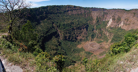
. The crater has been nearly filled with a relatively newer edifice, the Boquerón volcano.
The city of San Salvador is adjacent to the volcano and the western section of the city actually lies among its slopes. Because of this close proximity, any geological activity of the volcano, whether eruptive or not, has the potential to result in catastrophic destruction and death to the city.
Despite this, the volcano is iconic of the city, and several TV and radio antennas are situated on the El Picacho peaks and the crater of Boqueron. El Picacho, the prominent peak is the highest elevation (1,960 meters altitude)
 The Boquerón edifice formed between 40,000 and 1580 years ago, filling up the G-1 eruption crater. the lavas of the Boquerón edifice contain more alkali element and iron oxide than the lavas of the san salvador edifice, allowing for a clear chemical distinction.
Around 800 years ago, the present day crater was formed in a violent explosion. The crater, which gives it the present name (Boquerón means "big mouth" in Spanish) is 1.5 km in diameter and 500m deep. Within the crater around the upper walls, crops are cultivated by the locals who live on the volcano.
The magma chamber which the volcano sits upon contains a number of fissures which protrude along the flanks and sides of the volcano. The northwest (N40W) fissure has been the most active recently, with such significant eruptive events, such as the Loma Caldera eruption which buried the ancient village of Ceren
and the eruption of El Playon (1658–71) which buried the town of Nexapa. The citizens relocated to Nejapa
and nowadays the eruption is celebrated annually.
The most recent eruption in 1917 caused a flank eruption on the volcano along the N40W fissure. During this eruption, the crater lake
inside the Boqueron evaporated and a cinder cone
appeared, christened 'Boqueroncito'.
Stratovolcano
A stratovolcano, also known as a composite volcano, is a tall, conical volcano built up by many layers of hardened lava, tephra, pumice, and volcanic ash. Unlike shield volcanoes, stratovolcanoes are characterized by a steep profile and periodic, explosive eruptions...
situated northwest to the city of San Salvador
San Salvador
The city of San Salvador the capital and largest city of El Salvador, which has been designated a Gamma World City. Its complete name is La Ciudad de Gran San Salvador...
. The crater has been nearly filled with a relatively newer edifice, the Boquerón volcano.
The city of San Salvador is adjacent to the volcano and the western section of the city actually lies among its slopes. Because of this close proximity, any geological activity of the volcano, whether eruptive or not, has the potential to result in catastrophic destruction and death to the city.
Despite this, the volcano is iconic of the city, and several TV and radio antennas are situated on the El Picacho peaks and the crater of Boqueron. El Picacho, the prominent peak is the highest elevation (1,960 meters altitude)
San Salvador edifice
The San Salvador edifice formed more than 70,000 years ago, creating an edifice about 10 to 14 km in diameter and 3000m above sea level. Later, an explosive eruptive episode called 'G-1' (about 40,000 to 50,000 years ago) formed a crater that was 4.5 km by 6 km in size. The Picacho and Jabali peaks are the remnants of this crater. The G-1 episode erupted a dacitic pumice effusion, likely in a plinian style eruption.Boquerón edifice
Around 800 years ago, the present day crater was formed in a violent explosion. The crater, which gives it the present name (Boquerón means "big mouth" in Spanish) is 1.5 km in diameter and 500m deep. Within the crater around the upper walls, crops are cultivated by the locals who live on the volcano.
The magma chamber which the volcano sits upon contains a number of fissures which protrude along the flanks and sides of the volcano. The northwest (N40W) fissure has been the most active recently, with such significant eruptive events, such as the Loma Caldera eruption which buried the ancient village of Ceren
Joya de Cerén
Joya de Cerén is an archaeological site in La Libertad Department, El Salvador featuring a pre-Columbian Maya farming village preserved remarkably intact under layers of volcanic ash...
and the eruption of El Playon (1658–71) which buried the town of Nexapa. The citizens relocated to Nejapa
Nejapa
Nejapa is a municipality in the San Salvador department of El Salvador. It is the city after Apopa and before Quezaltepeque. People from Nejapa Are known as Nejapenses. One of the major traditions of Nejapa is "Las Bolas De Fuego" . It is celebrated Every 31st of August. Las Bolas de Fuego has two...
and nowadays the eruption is celebrated annually.
The most recent eruption in 1917 caused a flank eruption on the volcano along the N40W fissure. During this eruption, the crater lake
Crater lake
A crater lake is a lake that forms in a volcanic crater or caldera, such as a maar; less commonly and with lower association to the term a lake may form in an impact crater caused by a meteorite. Sometimes lakes which form inside calderas are called caldera lakes, but often this distinction is not...
inside the Boqueron evaporated and a cinder cone
Cinder cone
According to the , Cinder Cone is the proper name of 1 cinder cone in Canada and 7 cinder cones in the United States:In Canada: Cinder Cone In the United States:...
appeared, christened 'Boqueroncito'.
External links
- http://vulcan.wr.usgs.gov/Volcanoes/ElSalvador/Publications/OFR01-366/framework.html - Topographical hazard zonation maps regarding the volcano and the city