

San Saba River
Encyclopedia
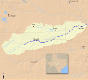
The San Saba River is a river in the U.S. state
U.S. state
A U.S. state is any one of the 50 federated states of the United States of America that share sovereignty with the federal government. Because of this shared sovereignty, an American is a citizen both of the federal entity and of his or her state of domicile. Four states use the official title of...
of Texas
Texas
Texas is the second largest U.S. state by both area and population, and the largest state by area in the contiguous United States.The name, based on the Caddo word "Tejas" meaning "friends" or "allies", was applied by the Spanish to the Caddo themselves and to the region of their settlement in...
. It is an undeveloped and scenic waterway located on the northern boundary of the Edwards Plateau
Edwards Plateau
The Edwards Plateau is a region of west-central Texas which is bounded by the Balcones Fault to the south and east, the Llano Uplift and the Llano Estacado to the north, and the Pecos River and Chihuahuan Desert to the west. San Angelo, Austin, San Antonio and Del Rio roughly outline the area...
.
Course
It begins in two primary branches. The North Valley Prong runs east through Schleicher County for 37 miles, while the Middle Valley Prong runs 35 miles through the same county. Both merge near Fort McKavettFort McKavett, Texas
Fort McKavett is a ghost town in Menard County, Texas, United States. It lies at the intersections of Farm to Market Road 864 and Farm to Market Road 1674, twenty miles southwest of the county seat Menard, Texas. Its elevation is 2,169 feet...
to form the San Saba river, which flows another 140 miles east/northeast until it drains into the Colorado River
Colorado River (Texas)
The Colorado River is a river that runs through the U.S. state of Texas; it should not be confused with the much longer Colorado River which flows from Colorado into the Gulf of California....
.
A major tributary is Brady Creek, which is itself 90 miles long and parallels the path of the San Saba to the north.
History
The river was named by the governor of Spanish TexasSpanish Texas
Spanish Texas was one of the interior provinces of New Spain from 1690 until 1821. Although Spain claimed ownership of the territory, which comprised part of modern-day Texas, including the land north of the Medina and Nueces Rivers, the Spanish did not attempt to colonize the area until after...
, Juan Antonio Bustillo y Ceballos
Juan Antonio Bustillo y Ceballos
Juan Antonio Bustillo y Ceballos was a soldier and governor of Texas and Coahuila, Mexico. He also served as alcalde ordinario in Mexico City.- Biography :...
, in 1732. He called it Río de San Sabá de las Nueces, because he and his troops had arrived on the feast day of St. Sabbas
Sabbas the Sanctified
Saint Sabbas the Sanctified , a Cappadocian-Greek monk, priest and saint, lived mainly in Palaestina Prima. He was the founder of several monasteries, most notably the one known as Mar Saba...
, a sixth-century monk. Santa Cruz de San Sabá Mission was established on the river in 1757.