
San Pablo Reservoir
Encyclopedia
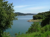
The San Pablo Reservoir is an open cut terminal water storage reservoir owned and operated by the East Bay Municipal Utility District
(EBMUD). It is located in the valley of San Pablo Creek
, north of Orinda, California
and south of El Sobrante
and Richmond
, east of the Berkeley Hills
between the Sobrante and San Pablo Ridges.
The earthen dam, built in 1919, is located at the El Sobrante end of the reservoir, above Kennedy Grove
. The reservoir has a total capacity of 38600 acre.ft, and a watershed of 23.37 square miles (61 km²). The San Pablo Dam Road runs along the west side of the reservoir. EBMUD's Briones Reservoir
is in the hills southeast of the San Pablo Reservoir and drains into the reservoir.
Although the dam impounds the waters of San Pablo Creek, the great bulk of its water is imported via aqueduct from Pardee Reservoir located over a hundred miles to the east in the Sierra Nevada
foothills.
Because this reservoir is a storage facility for drinking water, swimming and wading are prohibited. Fishing, boating, and canoeing are allowed. However, to reduce the possibility of gasoline components in the reservoir, only four-cycle engines using MTBE-free gasoline are allowed.
There is a 5 ½ mile (9 km) hiking and biking trail along the west side of the reservoir. Most of this trail is on the Old San Pablo Dam Road, replaced in the 1950s by the current San Pablo Dam Road. It is not possible to legally circumnavigate the reservoir on hiking trails. While there are trails on the east side of the reservoir to accommodate a circumnavigation, they are off limits even to people with EBMUD Trail Permits, and the roadway on top of San Pablo Dam proper is similarly restricted.
Many anglers fish on the reservoir for smallmouth bass, white sturgeon, bluegill and crappie, along with the regularly planted trout and catfish. (Read 2009 California EPA Health Advisory Guidelines on safety of eating fish from San Pablo Dam Reservoir)
Plans were made to seismically upgrade the dam without taking it out of commission, by mixing concrete into the soil at the toe of the dam, and by adding a new buttress layer above that on the downstream side of the dam. Construction was scheduled to take about two years.
Construction began August 2008 and completed in September of 2010.
East Bay Municipal Utility District
East Bay Municipal Utility District , colloquially referred to as "East Bay Mud", provides water and sewage treatment for customers in portions of Alameda County and Contra Costa County in California, on the eastern side of San Francisco Bay, including the cities of Richmond, El Cerrito, Hercules,...
(EBMUD). It is located in the valley of San Pablo Creek
San Pablo Creek
San Pablo Creek is an creek in Contra Costa County, California, United States, which drains the canyon or valley between the San Pablo Ridge and the Sobrante Ridge, parts of the Pacific Coast Ranges east of San Francisco Bay....
, north of Orinda, California
Orinda, California
-2010:The 2010 United States Census reported that Orinda had a population of 17,643. The population density was 1,389.5 people per square mile . The racial makeup of Orinda was 14,533 White, 149 African American, 22 Native American, 2,016 Asian, 24 Pacific Islander, 122 from other races, and...
and south of El Sobrante
El Sobrante, California
El Sobrante is a census-designated place in Contra Costa County, California, United States. The population was 12,669 at the 2010 census...
and Richmond
Richmond, California
Richmond is a city in western Contra Costa County, California, United States. The city was incorporated on August 7, 1905. It is located in the East Bay, part of the San Francisco Bay Area. It is a residential inner suburb of San Francisco, as well as the site of heavy industry, which has been...
, east of the Berkeley Hills
Berkeley Hills
The Berkeley Hills are a range of the Pacific Coast Ranges that overlook the northeast side of the valley that surrounds San Francisco Bay. They were previously called the "Contra Costa Range/Hills" , but with the establishment of Berkeley and the University of California, the current usage was...
between the Sobrante and San Pablo Ridges.
The earthen dam, built in 1919, is located at the El Sobrante end of the reservoir, above Kennedy Grove
Kennedy Grove Regional Recreation Area
Kennedy Grove Regional Recreation Area is an East Bay Regional Parks facility located at the foot of the San Pablo Dam in Richmond, California. This park, opened in 1967, is named after the late U.S. President John F. Kennedy...
. The reservoir has a total capacity of 38600 acre.ft, and a watershed of 23.37 square miles (61 km²). The San Pablo Dam Road runs along the west side of the reservoir. EBMUD's Briones Reservoir
Briones Reservoir
Briones Reservoir is an open cut terminal water storage reservoir owned and operated by the East Bay Municipal Utility District . It is located in the hills northeast of Orinda, California. The earthen dam was completed in 1964...
is in the hills southeast of the San Pablo Reservoir and drains into the reservoir.
Although the dam impounds the waters of San Pablo Creek, the great bulk of its water is imported via aqueduct from Pardee Reservoir located over a hundred miles to the east in the Sierra Nevada
Sierra Nevada (US)
The Sierra Nevada is a mountain range in the U.S. states of California and Nevada, between the California Central Valley and the Basin and Range Province. The Sierra runs north-to-south, and is approximately across east-to-west...
foothills.
Recreation
EBMUD owns and maintains the San Pablo Reservoir Recreation Area, which consists of boating and fishing access to the reservoir itself, and some watershed land on the west side of the reservoir. EBMUD charges $6 for daily entrance into the park. The recreation area is managed under contract by Urban Parks Concessionaires (UPC) and includes a restaurant (The San Pablo Grill) and gift shop, where fishing permits can be purchased and boats can be rented. There are picnic areas available, a children’s play area and a boat launch ramp.Because this reservoir is a storage facility for drinking water, swimming and wading are prohibited. Fishing, boating, and canoeing are allowed. However, to reduce the possibility of gasoline components in the reservoir, only four-cycle engines using MTBE-free gasoline are allowed.
There is a 5 ½ mile (9 km) hiking and biking trail along the west side of the reservoir. Most of this trail is on the Old San Pablo Dam Road, replaced in the 1950s by the current San Pablo Dam Road. It is not possible to legally circumnavigate the reservoir on hiking trails. While there are trails on the east side of the reservoir to accommodate a circumnavigation, they are off limits even to people with EBMUD Trail Permits, and the roadway on top of San Pablo Dam proper is similarly restricted.
Many anglers fish on the reservoir for smallmouth bass, white sturgeon, bluegill and crappie, along with the regularly planted trout and catfish. (Read 2009 California EPA Health Advisory Guidelines on safety of eating fish from San Pablo Dam Reservoir)
Seismic Retrofit
In October 2004, a study commissioned by EBMUD concluded that a major earthquake on the Hayward Fault could cause the San Pablo Dam to settle as much as 35 feet (11 m). As a short-term measure, the District has lowered the reservoir level by 20 feet (6 m) to create a 35 foot (11 m) buffer.Plans were made to seismically upgrade the dam without taking it out of commission, by mixing concrete into the soil at the toe of the dam, and by adding a new buttress layer above that on the downstream side of the dam. Construction was scheduled to take about two years.
Construction began August 2008 and completed in September of 2010.