

Sailing Directions
Encyclopedia
 |
|
| Purpose: | Describe features of ocean basins, coastlines, ports, and harbors |
|---|---|
| Publication Frequency: | Irregular |
| Published by: | National Geospatial-Intelligence Agency National Geospatial-Intelligence Agency The National Geospatial-Intelligence Agency is an agency of the federal government of the United States with the primary mission of collecting, analyzing and distributing geospatial intelligence in support of national security. NGA was formerly known as the National Imagery and Mapping Agency ... |
| Available Online: | All volumes http://www.nga.mil/portal/site/maritime/ |
Sailing Directions is a 42-volume American navigation
Navigation
Navigation is the process of monitoring and controlling the movement of a craft or vehicle from one place to another. It is also the term of art used for the specialized knowledge used by navigators to perform navigation tasks...
publication published by the National Geospatial-Intelligence Agency
National Geospatial-Intelligence Agency
The National Geospatial-Intelligence Agency is an agency of the federal government of the United States with the primary mission of collecting, analyzing and distributing geospatial intelligence in support of national security. NGA was formerly known as the National Imagery and Mapping Agency ...
(NGA). Sailing Directions consists of 37 Enroute volumes, 4 Planning Guide volumes, and 1 volume combining both types. Planning Guides describe general features of ocean basins and country-specific information such as firing areas, pilotage requirements, regulations, search and rescue information, ship reporting systems, and time zones, to name a few; Enroutes describe features of coastlines, ports, and harbors.
Sailing Directions are updated when new data requires extensive revision of an existing text. These data are obtained from several sources, including, but not limited to, pilots and Sailing Directions from other countries.
One book comprises the Planning Guide and Enroute for Antarctica. This consolidation allows for a more effective presentation of material on this unique area.
Sailing Directions (Planning Guide) and Sailing Directions (Enroute) are frequently updated. In early 2005, NGA discontinued production of these publications in printed form; subsequent editions were distributed in digital form only. Between editions, Sailing Directions are corrected via a binary patch process referred to as Publication Data Update (PDU).
Sailing Directions (Planning Guide)
oceanic voyage, as well as giving information on individual countries that is applicable to all ports in those countries. Each of the Planning Guides covers an area determined by an arbitrary division of the world’s seas.
Individual Planning Guides are divided into Countries and Ocean Basins, as follows:
- Pub. 120--51 Countries and 1 Ocean Basin (Pacific Ocean).
- Pub. 140--87 Countries and 6 Ocean Basins (Baltic Sea, Black Sea, Caribbean Sea, Mediterranean Sea, North Atlantic Ocean, and North Sea/English Channel).
- Pub. 160--61 Countries and 3 Ocean Basins (Indian Ocean, South Atlantic Ocean, and Red Sea/Persian Gulf).
- Pub. 180--5 Countries and 1 Ocean Basin (Arctic Ocean).
Country entries may contain information on the following subjects—Buoyage Systems, Currency, Firing Areas, Fishing Areas, Government, Holidays, Ice, Industries, Languages, Mined Areas, Navigational Information (to include maritime claims, maritime boundary
Maritime boundary
Maritime boundary is a conceptual means of division of the water surface of the planet into maritime areas that are defined through surrounding physical geography or by human geography. As such it usually includes areas of exclusive national rights over the mineral and biological resources,...
disputes, and enroute volumes), Offshore Drilling, Pilotage, Pollution, Prohibited Areas, Regulations, Restricted Areas, Search and Resuce, Signals, Submarine Operating Areas, Time Zone, Traffic Separation Schemes, U.S. Embassy, and Vessel Traffic Services. Information that cannot be accurately depicted within the alphabeticized Country text may be listed as an Appendix at the end of the Country text.
Ocean Basin entries may contain information on the following subjects—Climatology, Currents, Fishing Areas, Geophysical Features, Ice, Ionospheric Disturbance, Magnetic Field, Meteoroloy, Mined Areas, Navigational Information, Optical Phenomenon, Pilotage, Pollution, Regulations, Routes, Seas, Ship Reporting Systems, Tides, and Surface Temperatures.
Sailing Directions (Enroute)
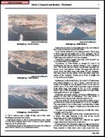
Each Sailing Directions (Enroute) volume contains numbered sections along a coast or through a strait. Figure 404a illustrates this division. Each sector is discussed in turn. A preface with detailed information about
authorities, references, and conventions used in each book precedes the sector discussions. Finally, each book provides conversions between feet, fathoms, and meters.
The Chart Information Graphic, the first item in each chapter, is a graphic key for charts pertaining to a sector. See Figure 404b. The graduation of the border scale of the chartlet enables navigators to identify the largest scale chart for a location and to find a feature listed in the Index-Gazetteer.
These graphics are not maintained by Notice to Mariners; one should refer to the chart catalog for updated chart listings.
Other graphics may contain special information on local winds and weather, anchorages, significant coastal features, and navigation dangers.
A foreign terms glossary and a comprehensive Index-Gazetteer follow the sector discussions.
The Index-Gazetteer is an alphabetical listing of described and charted features. The Index lists each feature by geographic coordinates and sector number.
Source
The text of this article originated from sections 402 to 404 of The American Practical Navigator, a document produced by the government of the United States of AmericaUnited States
The United States of America is a federal constitutional republic comprising fifty states and a federal district...
and amended by Marine Analysts at the National Geospatial-Intelligence Agency.
See also
- American Practical Navigator
- BuoyBuoyA buoy is a floating device that can have many different purposes. It can be anchored or allowed to drift. The word, of Old French or Middle Dutch origin, is now most commonly in UK English, although some orthoepists have traditionally prescribed the pronunciation...
- Coast PilotsCoast PilotsUnited States Coast Pilots is a nine-volume American navigation publication distributed yearly by the National Oceanic and Atmospheric Administration's Office of Coast Survey. The purpose of the publication is to supplement nautical charts of United States of America waters. Information comes...
- Light ListLight ListThe United States Coast Guard Light List is an American navigation publication in 7 volumes made available yearly by the U.S. Coast Guard which gives information on lighted navigation aids, unlighted buoys, radiobeacons, radio direction finder calibration stations, daybeacons, racons, and LORAN...
- List of Lights
- Local Notice to MarinersLocal Notice to MarinersA Local Notice to Mariners is an authoritative instruction issued by a designated official, typically the harbormaster.-United States:In the United States, notices are issued by each U.S. Coast Guard District to disseminate important information affecting navigational safety within that District...
- Notice to MarinersNotice to MarinersA notice to mariners advises mariners of important matters affecting navigational safety, including new hydrographic information, changes in channels and aids to navigation, and other important data.Over 60 countries which produce nautical charts also...
External links
- Chapter 4: Nautical Publications - from the online edition of Nathaniel BowditchNathaniel BowditchNathaniel Bowditch was an early American mathematician remembered for his work on ocean navigation. He is often credited as the founder of modern maritime navigation; his book The New American Practical Navigator, first published in 1802, is still carried on board every commissioned U.S...
's American Practical Navigator - All Enroute and Planning Guide volumes for PDF download
- Fast direct download of individual volumes - replace XYZ with Pub. Number
- Coast Pilots These nine volumes correspond to the Sailing Directions in the United States and Territories