
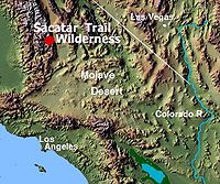
Sacatar Trail Wilderness
Encyclopedia
Ridgecrest, California
Ridgecrest, formerly known as Crumville, was incorporated as a city in 1913. It is located in the Indian Wells Valley in northeastern Kern County, California, adjacent to the Naval Air Weapons Station China Lake . Ridgecrest is the only incorporated city along US 395 in Kern County...
USA.
It was created in 1994 with the passage of the California Desert Protection Act - Public Law
Public law
Public law is a theory of law governing the relationship between individuals and the state. Under this theory, constitutional law, administrative law and criminal law are sub-divisions of public law...
103-433 - and is managed by the Bureau of Land Management
Bureau of Land Management
The Bureau of Land Management is an agency within the United States Department of the Interior which administers America's public lands, totaling approximately , or one-eighth of the landmass of the country. The BLM also manages of subsurface mineral estate underlying federal, state and private...
(BLM).
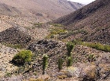
The wilderness is 51900 acres (210 km²) in size and protects portions of the southern Sierra Nevada Mountain Range.
History
The Sacatar Trail was the only route into the Owens ValleyOwens Valley
Owens Valley is the arid valley of the Owens River in eastern California in the United States, to the east of the Sierra Nevada and west of the White Mountains and Inyo Mountains on the west edge of the Great Basin section...
from the West before the road over Walker Pass
Walker Pass
Walker Pass is a mountain pass by Lake Isabella in the southern Sierra Nevada mountains. It is located in northeastern Kern County, approximately 53 mi ENE of Bakersfield and 10 mi WNW of Ridgecrest...
was built. Cattle, soldiers, and commercial traffic used this trail. It is the only designated hiking trial within the wilderness and is about nine miles (14 km) in length.
Landscape
Elevations in the wilderness are from 3541 feet (1,079.3 m) to 8800 feet (2,682.2 m).The wilderness contains an "ecotone
Ecotone
An ecotone is a transition area between two biomes but different patches of the landscape, such as forest and grassland. It may be narrow or wide, and it may be local or regional...
" formed by the convergence of desert and Sierran vegetative communities and encompasses a narrow band along the southern Sierra crest between Nine Mile Canyon in the south and Sequoia National Forest
Sequoia National Forest
Sequoia National Forest is located in the southern Sierra Nevada mountains of California. The U.S. National Forest is named for the majestic Giant Sequoia trees which populate 38 distinct groves within the boundaries of the forest....
to the north. The boundary includes the desert-like eastern face of the Sierra Nevada Range where broad alluvial fan
Alluvial fan
An alluvial fan is a fan-shaped deposit formed where a fast flowing stream flattens, slows, and spreads typically at the exit of a canyon onto a flatter plain. A convergence of neighboring alluvial fans into a single apron of deposits against a slope is called a bajada, or compound alluvial...
s or bahadas collect from Rose Valley. Height from Rose Valley up to the granite crest is as much as a mile. Five steep canyons cut through the east side with several perennial springs.
Flora and fauna
The perennial springs support riparian growth of Fremont cottonwood trees, willowWillow
Willows, sallows, and osiers form the genus Salix, around 400 species of deciduous trees and shrubs, found primarily on moist soils in cold and temperate regions of the Northern Hemisphere...
s and grasses. The higher elevations have single-leaf pinyon pine and Jeffrey Pine
Jeffrey Pine
The Jeffrey Pine, Pinus jeffreyi, named in honor of its botanist documenter John Jeffrey, is a North American pine related to Ponderosa Pine.-Distribution and habitat:...
trees. Higher elevations have isolated stands of ponderosa pine and red fir. Within the area is one known population of Phacelia novermillensis, also known as Nine Mile Canyon phacelia, and is an annual plant native to California and is toxic, causing dermatitis
Dermatitis
-Etymology:Dermatitis derives from Greek derma "skin" + -itis "inflammation" and genetic disorder.-Terminology:There are several different types of dermatitis. The different kinds usually have in common an allergic reaction to specific allergens. The term may describe eczema, which is also called...
.
Recreation and access
Recreation activities are day-hikingHiking
Hiking is an outdoor activity which consists of walking in natural environments, often in mountainous or other scenic terrain. People often hike on hiking trails. It is such a popular activity that there are numerous hiking organizations worldwide. The health benefits of different types of hiking...
, backpacking
Backpacking (wilderness)
Backpacking combines the activities of hiking and camping for an overnight stay in backcountry wilderness...
and pinyon
Pinyon pine
The pinyon pine group grows in the southwestern United States and in Mexico. The trees yield edible pinyon nuts, which were a staple of the Native Americans, and are still widely eaten...
nut gathering. A California Campfire permit is required for open fires or backpack stoves.
The trail crosses the wilderness from east to west, with the east side a steep and strenuous climb. Starting at the west trailhead and traveling east is recommended.
The eastside trailhead is difficult to find because of minimal signage. A topographic map (Little Lake quad) or the BLM map of the area is helpful.
The Bureau of Land Management encourages the practice of Leave No Trace
Leave No Trace
Leave No Trace is both a set of principles, and an organization that promotes those principles. The principles are designed to assist outdoor enthusiasts with their decisions about how to reduce their impacts when they hike, camp, picnic, snowshoe, run, bike, hunt, paddle, ride horses, fish, ski or...
principles of outdoor travel to minimize human impact on the environment.