
Sa Kaeo Province
Encyclopedia
Sa Kaeo is a province
(changwat) of Thailand
.
It is located in the east of Thailand. Neighboring provinces are (from south clockwise) Chanthaburi
, Chachoengsao
, Prachin Buri
, Nakhon Ratchasima
and Buri Ram
. To the east it borders Banteay Meanchey and Battambang
of Cambodia
.
and Nong Bua Lam Phu.
In 1979 Sa Kaeo Refugee Camp
was established to the northwest of Sa Kaeo town.
, the southern prolongation of the Dong Phaya Yen range
. To the south are foothill plains, which are mostly deforested.
Two national parks are located in the Cardamom Mountains
at the border to Cambodia, protecting the rain forests. Pang Sida National Park
was established in 1982, Ta Phraya National Park in 1996.
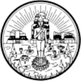
shows the sun rising over the archeological ruins Prasart Kao Noi Si Chom Poo, an important Khmer
temple. The rising sun symbolizes the location of the province in the east. In the front is a Buddha
image in a pond with lotus
flowers.
Provincial tree is Phyllonthus emblica, the provincial flower is the Orange Jessamine (Murraya paniculata).
The provincial slogan is The Frontier of the East, Beautiful Forests and Splendid Waterfalls, Plenty of Ancient Civilisations and the Commercial Venue between Thailand and Cambodia.
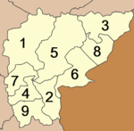 Sa Kaeo is subdivided into 9 districts (amphoe
). The districts are further subdivided into 59 subdistricts (tambon
) and 619 villages (muban
).
City Pillar Shrine (ศาลหลักเมือง) Within the shrine stands the city pillar made of Chaiyaphruek or cassia wood whose characteristics are in accordance with the ancient tradition. This shrine is evidence of the solidarity of the people and a symbol of the loyalty to King Rama IX, as well as, a centre of spirit and unity of the people of Sa Kaew.
Pang Sida National Park (อุทยานแห่งชาติปางสีดา) It comprises steep undulating mountain ranges, moist evergreen forest, hill evergreen forest, dry evergreen forest, deciduous dipterocarp forest, savanna, etc. It is also a remaining source of freshwater crocodiles and origin of many rivers and streams. Within the national park, there are many interesting attractions as follows:
Namtok Pang Sida (น้ำตกปางสีดา) It is a 3–tier waterfall with a height of 10 metres. The water drops to the lower large water basin and stone terrace surrounded by shady atmosphere.
Namtok Pha Takhian (น้ำตกผาตะเคียน) It is the last cataract that shares a similar stream with Namtok Pang Sida. The water is dropping from a 10-metre cliff.
Thungya Pong Krathing (ทุ่งหญ้าโป่งกระทิง) was originally an old village which has become an abandoned grass field after the people migrated out from this area. The park has settled an artificial salt lick and an animal observatory tower.
Namtok Tham Khangkhao (น้ำตกถ้ำค้างคาว) Near the waterfall, there are many bats - Khangkhao - in the cave.
Namtok Thap Sung (น้ำตกทับซุง) is a new waterfall of the National Park. Along the way, there is a nature study route, where there are various kinds of plants.
The Viewpoint Spot (จุดชมวิว) is a wide valley. The surrounding scenery, picturesque sunrises and sunsets can be admired from this spot.
A Group of Khwae Makha Waterfalls (กลุ่มน้ำตกแควมะค่า) The Khwae Makha Waterfall drops from a 70-metre high cliff. Trekking and camping can be done.
Phukhao Chedi (ภูเขาเจดีย์) is an accumulation of rocks with cracks similar to those at Phu Hin Rong Kla. It is 4 metres high, while its circumference is 25 metres.
Freshwater Crocodiles at Kaeng Yai Mak (แหล่งจระเข้น้ำจืดแก่งยายมาก) It is a place where freshwater crocodiles have been discovered since 1981 to have remained in the Huai Nam Yen Forest, where there is an observatory tower provided near the National Park’s Po Do 1 (Kaeng Yai Mak) Ranger Station.
Tha Krabak Reservoir (อ่างเก็บน้ำท่ากระบาก) It is a large reservoir under the Royal Initiative of H.M. the King to improve the irrigation system on the plain in the valley. It is an earthfill dam with a height of 17.5 metres and a length of 720 metres.
Namtok Tha Krabak (น้ำตกท่ากระบาก) The waterfall comprises 3 tiers. Each tier is 400 - 500 metres apart from one another.
Khao Chakan (เขาฉกรรจ์) It is a limestone mountain whose ridge is 90 degrees against the north and the south. Its summit is 240 metres above sea level. Khao Chakan is the largest and stands in the middle between Phukhao Ming on the left and Khao Falami on the right. The three mountains are established as the Khao Chakan Arboretum under the supervision of the Department of National Park, Wildlife and Flora.
Wat Tham Khao Chakan (วัดถ้ำเขาฉกรรจ์) It is a temple of the Mahayana sect of Buddhism. There are 72 small caves within the compound of Khao Chakan. The popular ones are Tham Muet, Tham Hanuman, Tham Khao Thalu, Tham Mahahing, Tham Namthip and Tham Kaew Phlai Chumphon. The spot of interest is the replica of the Buddha’s footprint at Tham Khao Thalu.
Khao Sam Sip Reservoir (อ่างเก็บน้ำเขาสามสิบ) It is under the supervision of the Khao Chakan Development Project (Ban Khao Sam Sip) under the Royal Initiative.
Khao Chakan Arboretum (สวนรุกขชาติเขาฉกรรจ์) The three mountains are established as Khao Chakan Arboretum under the supervision of the Department of National Park, Wildlife and Flora. The arboretum is a residence of wild monkeys, as well as, millions of bats flying in long lines in the evening.
Bamboo Ceramic Basketry Village (หมู่บ้านหัตถกรรมจักสานล้อมเซรามิก) The housewives of this village come together and form a group in the form of a cooperative known as Chai Phatthana Women Cooperative.
Namtok Khao Takrup (น้ำตกเขาตะกรุบ) It is another beautiful waterfall. Along both sides, a variety of plants and birds will be found.
Wang Namyen Hospital (โรงพยาบาลวังน้ำเย็น) is a model hospital, which conducts herbal treatment and healthcare.
King Amphoe Wang Sombun
Wangnamyen Dairy Cooperative Limited (สหกรณ์โคนมวังน้ำเย็น จำกัด) It is the second biggest dairy production venue of the country, established in 1987. At present, there are more than 1,000 members and more than 30,000 milk cows with a production capacity of 70 tones of raw milk a day.
Namtok Khao Sip Ha Chan (น้ำตกเขาสิบห้าชั้น) It is a very beautiful waterfall due to the large amount of water flowing throughout the year. The surrounding area is abundant with forest and a variety of birds.
Queen Sirikit Chaloem Phra Kiat Public Water Park (สวนน้ำสาธารณะเฉลิมพระเกียรติ สมเด็จพระนางเจ้าสิริกิติ์ พระบรมราชินีนาถ) It is a big irrigation reservoir, covering an area of 250 rai, with beautiful scenery of mountains and streams.
Tham Nam (ถ้ำน้ำ) It is a cave with a running stream throughout the year. Inside the cave are beautiful stalagmites and stalactites. Moreover, there is a small waterfall inside the cave.
Chong Klam Bon Wildlife Breeding Station (สถานีเพาะเลี้ยงสัตว์ป่าช่องกล่ำบน) This station is an office under the supervision of the Department of National Park, Wildlife and Flora, established in 1983 under the Royal Initiative of H.M the Queen, to be a breeding station for rare and endangered animals. It is also a research station on the wildlife, providing knowledge and understanding on wild animals.
Phra Prong Dam (เขื่อนพระปรง) is the largest irrigation dam in Sa Kaew. Most of the area is forest within the compound of the Pang Sida National Park, which has become flooded, making its scenery beautiful.
King Naresuan the Great’s Statue (พระบรมราชานุสาวรีย์สมเด็จพระนเรศวรมหาราช) This statue was erected because in the past, Watthana Nakhon District was once an area where King Naresuan the Great resided during the battles in the East in 1593.
Luangpho Thong or Phrakhru Rattana Sarathikhun (หลวงพ่อทอง หรือพระครูรัตนสราธิคุณ) is a monk of Wat Sa Kaew, Mueang District, Sa Kaew. The monk uses his medical skills to treat and cure sick people, as well as, is a developer. Therefore, he has been widely respected among the people of Sa Kaew and nearby provinces who come to pay respect and ask for their prosperous lives.
Wat Nakhon Tham (วัดนครธรรม) Within the compound of the temple are interesting attractions, Luangpho Khao, an ancient Buddha image aged around 100 years in a cross-legged posture, and cast of lime (white soil from Nong Din Chi). Furthermore, the Luangpho Khao’s hall also houses the Buddha’s Relics, brought from Wat Pamadunla Racha Maha Wihan, in Ratnapura, Sri Lanka, a replica of the Buddha’s Footprint and the image of Phra Siam Devadhiraj.
Prasat Ban Noi (ปราสาทบ้านน้อย) It is divided into 3 rooms inside: one each in the north and south, while the other is at the centre. Outside the boundary wall lays a pond in the northeast. Inside the boundary wall in the southeastern corner stands a construction made of laterite. It is a Bannalai - a library. At the centre inside the boundary wall is a Prang whose base was made of laterite with a height of 1 metre.
The Replica of Phra Siam Devadhiraj Image (พระสยามเทวาธิราช) The replica was taken to the frontier for protecting the soldiers, policemen, and people from the fighting. At present, Phra Siam Devadhiraj is a sacred image of the people of Aranyaprathet and those in the nearby provinces.
Wat Anubanphot or Khao Noi (วัดอนุบรรพต หรือ เขาน้อย). Inside the temple is a beautiful ordination hall, different from others because of its square base with a width of 11.5 metres, and its pointed traditional Thai spired roof decorated in the Thai style of art.
The Plant Genetic Preservation Project under the Royal Initiative of Her Royal Highness Princess Maha Chakri Sirindhorn (โครงการอนุรักษ์พันธุกรรมพืช อันเนื่องมาจากพระราชดำริ สมเด็จพระเทพรัตนราชสุดาฯ สยามบรมราชกุมารี) It is open as an ecotourism attraction for tourists with a speaker guiding around the place and providing an explanation on various species of plants, herbs, as well as, the 1,500 – 2,000 flying foxes, residing in this area for 10 years.
Prasat Khao Noi Si Chomphu (ปราสาทเขาน้อยสีชมพู) It is believed to have been a Hindu shrine. The Prasat is made of bricks without any use of mortar. It comprises 3 brick constructions; namely, the northern Prang, the central Prang, and the southern Wihan. However, only the central one remains in quite a good condition, while only the bases of the northern and the southern ones are left.
Prasat Mueang Phai (ปราสาทเมืองไผ่) The interesting object is an ancient chedi made of bricks into a rectangular shape with 4 porticos engraved into beautiful floral, vine and personage designs.
Talat Rong Kluea or Talat Chaidaen Ban Khlong Luek (ตลาดโรงเกลือหรือ ตลาดชายแดนบ้านคลองลึก) is an important border market on the Thai side. Most products are from the Cambodian border such as brass products, glazed products, ceramics, crockery, clothes, curtains, electronic appliances from Russia, woven products, dried fish, etc.
Aranyaprathet Victory Gate (ประตูชัยอรัญประเทศ) is situated on the Thailand – Cambodia border at Ban Khlong Luek, Tha Kham Sub-district. The gate consists of two posts standing on the opposite sides of the road.
Prasat Sadok Kok Thom (ปราสาทสด๊กก๊อกธม) is a large important ancient monument of Sa Kaew Province. The remains comprise 3 towers, facing towards the East, a moat surrounding its 4 sides, as well as, 2 boundary walls: the outer one made of laterite, while the inner one, sandstone. There was a discovery of 2 stone inscriptions in ancient Khmer script.
Lalu (ละลุ) in Khmer language means “penetrated”. It is a natural phenomenon caused by the erosion of rainwater and the subsidence or collapse of soil. The condition of some part of the soil at this place is hard and durable. However, the wind has eroded it into many shapes similar to a city wall or cliffs, while some are pillars similar to those in “Phae Mueang Phi” of Phrae province, but smaller in size.
Prasat Khao Lon (ปราสาทเขาโล้น) The Prasat stands in the compound of Wat Prasat Khao Lon on the summit of Khao Lon, a small hill located at the foot of Khao Sakae Krong. It comprises 4 Prang towers, but only the central one remains until the present time.
Ta Phraya National Park (อุทยานแห่งชาติตาพระยา) It is a natural boundary bordering Thailand and Cambodia. The forest is in perfect condition comprising mixed deciduous forest, dry evergreen forest, and deciduous dipterocarp forest. The distinctive point of this national park is the variety of nature study routes for tourists.
Interesting Attractions within the Park
The Viewpoint Spot on Phanom Dong Rak Mountain Range (จุดชมวิวบนเทือกเขาพนมดงรัก) where Phran Nut and Sakae Krong Mountain Ranges will be seen.
Lan Krachiao (ลานกระเจียว) is a stone terrace where there is the splendour of Krachiao - curcuma - blossom and a perfect condition of the forest.
Chong O-Bok (ช่องโอบก) is a viewpoint at the end of Thailand’s frontier. From this spot, abundant forests and villages in the Kingdom of Cambodia can be seen.
Mi Akson Shrine (ศาลมีอักษร) houses the royal handwriting of King Rama V.
Khao Yak (เขายักษ์) is an ancient picture of a hermit engraved on a large stone.
Lan Hin Tat (ลานหินตัด) is a stone quarry with traces of the stone cutting process to construct a Prasat.
Cantaloupes (แคนตาลูป) The distinguishing point of Sa Kaew’s cantaloupes is its sweetness and crispness which exceed those of other places.
Silk of Ban Han Sai (ผ้าไหมบ้านหันทราย) is mainly produced at Han Sai Village, Han Sai Sub-district, Aranyaprathet District. It is a hand-woven fabric in traditional patterns with delicacy and uniqueness.
Basketry (เครื่องจักสาน) includes various forms of bamboo fishtraps and containers such as Sai, Krachang, Takhong, and Lop, as well as, sieves, winnowing baskets, and different forms of container baskets.
Bamboo Ceramics (จักสานล้อมเซรามิก) are the ceramic and wooden products wrapped with bamboo basketry. The products include vases and ash trays.
Wooden Products (ผลิตภัณฑ์ไม้) Wang Nam Yen District has been a famous production venue of Makha Mong - Afzelia xylocarpa - wooden products for a long time. It is also one of the main occupations of the locals as a family business. Most products are made of Makha Mong, Phayung – Siamese Rosewood, Chingchan – Rosewood, Pradu – Burma Padauk, and constructed into furniture such as dining tables, chairs, make-up desks, clocks, tissue boxes, and decorating accessories.
Suan Siriphon (สวนสิริพร)v is situated at 129 Mu 4, Sa Kaew – Chanthaburi Road, Wang Nam Yen District. The sweet tamarinds and seasonal fruits such as mangoes and santols.
Antiques and Used Objects (ของโบราณ ของเก่า) are products made of brass, wood, and ceramic. Most of them are replicas of the arts and patterns of ancient objects found at the frontier such as terra cotta Buddha images, god images in various stone Prasats.
I Koi Wine (ไวน์อีโก่ย) is Thai herbal wine, a product of Ta Phraya District. I Koi is a kind of wild grapes. It is a vine similar to a grape but its leaves are brown. Its fruits are in bunches similar to grapes, the younger ones are green or brown, but are not edible. Only the full ripen ones can be eaten. They will be dark brown with a sour taste and high Vitamin C.
The Sa Kaew Ban Rao Network Cooperation and Development Centre (ศูนย์ประสานงานและพัฒนาเครือข่ายสระแก้วบ้านเรา) coordinates the network of organisations in the community and offers both retail and wholesale Thai intellectual products.
Cantaloupe Day (วันแคนตาลูป) is held in front of the Aranyaprathet District Office during April of every year. It is the period when the cantaloupes are harvested and offered in the market. In the fair are cantaloupe floats, cantaloupe and agricultural produce contests, exhibitions of the government authorities, a cantaloupe beauty contest, a myriad of booths, as well as, various forms of entertainment.
Sa Kaew Establishment Commemoration (งานวันสถาปนาจังหวัดสระแก้ว) is organised approximately in December of every year. In the event, there will be cultural and art processions, exhibitions, as well as, booths offering many kinds of products.
Dok Kaew Blooming Day (งานวันดอกแก้วบานเบื้องบูรพา) is held yearly at the Si Aranyothai Kindergarten and in front of the Aranyaprathet Railway Station around December. In this event, there is a procession of the Dok Kaew Blooming Day, a light, sound and mixed media presentation, a singing contest and various forms of entertainment.
Provinces of Thailand
Thailand is divided into 76 provinces , which are geographically grouped into 6 regions. The capital Bangkok is not a province but a special administrative area and is included as the 77th province since it is administered at the same level as the other 76 provinces. The name of the provinces are...
(changwat) of Thailand
Thailand
Thailand , officially the Kingdom of Thailand , formerly known as Siam , is a country located at the centre of the Indochina peninsula and Southeast Asia. It is bordered to the north by Burma and Laos, to the east by Laos and Cambodia, to the south by the Gulf of Thailand and Malaysia, and to the...
.
It is located in the east of Thailand. Neighboring provinces are (from south clockwise) Chanthaburi
Chanthaburi Province
Chanthaburi is a province of Thailand. It is located in the east of Thailand, at the border to Battambang and Pailin of Cambodia and the shore to the Gulf of Thailand...
, Chachoengsao
Chachoengsao Province
Chachoengsao is a province of Thailand. Neighboring provinces are Prachin Buri, Sa Kaeo, Chanthaburi, Chon Buri, Samut Prakan, Bangkok, Pathum Thani and Nakhon Nayok. It also has a short coast to the Gulf of Thailand.-History:Chachoengsao or Paet Rio is a province in the Central region...
, Prachin Buri
Prachinburi Province
Prachin Buri is a province of Thailand. Neighboring provinces are Nakhon Ratchasima, Sa Kaeo, Chachoengsao and Nakhon Nayok.-Geography:...
, Nakhon Ratchasima
Nakhon Ratchasima Province
Nakhon Ratchasima or , often shortened to Korat or Khorat , is one of the north-eastern provinces of Thailand...
and Buri Ram
Buriram Province
Buri Ram or is one of the north-eastern provinces of Thailand. Neighboring provinces are Sa Kaeo, Nakhon Ratchasima, Khon Kaen, Maha Sarakham and Surin. To the south-east it borders Oddar Meancheay of Cambodia...
. To the east it borders Banteay Meanchey and Battambang
Battambang Province
Battambang is a province in northwestern Cambodia. It is bordered to the North with Banteay Meanchey, to the West with Thailand, and to the East and South with Pursat. The capital of the province is the city of Battambang. The name, meaning 'lost staff', refers to the legend of Preah Bat Dambang...
of Cambodia
Cambodia
Cambodia , officially known as the Kingdom of Cambodia, is a country located in the southern portion of the Indochina Peninsula in Southeast Asia...
.
History
Sa Kaeo became a province in 1993, when the six districts Sa Kaeo, Khlong Hat, Wang Nam Yen, Aranya Prathet, Ta Phraya and Watthana Nakhon of Prachin Buri were elevated to provincial status. It is thus one of the three youngest provinces of Thailand, together with Amnat CharoenAmnat Charoen Province
Amnat Charoen is one of the north-eastern provinces of Thailand. Neighboring provinces are Ubon Ratchathani, Yasothon and Mukdahan. To the east it borders Salavan of Laos.-Geography:...
and Nong Bua Lam Phu.
In 1979 Sa Kaeo Refugee Camp
Sa Kaeo Refugee Camp
Sa Kaeo Refugee Camp was the first organized refugee relief camp established on the Thai-Cambodian border by the Royal Thai Government with support from international relief agencies including the United Nations. It was opened in October 1979 and closed in early July 1980...
was established to the northwest of Sa Kaeo town.
Geography
The north of the province is covered with the forested mountains of the Sankambeng RangeSankambeng Range
The Sankamphaeng Range, also Sankambeng Range or Sungumpang Range is one of the mountain ranges separating Eastern Thailand from the northeast or Isan.-Description:This mountain chain runs in a WNW-ESE direction...
, the southern prolongation of the Dong Phaya Yen range
Dong Phaya Yen mountains
Dong Phaya Yen is a mountain range in central Thailand.-Description:Dong Phaya Yen is the southeastern extension of the Phetchabun mountains, dividing the Chao Phraya river valley of Central Thailand and the Khorat Plateau of the northeast...
. To the south are foothill plains, which are mostly deforested.
Two national parks are located in the Cardamom Mountains
Cardamom Mountains
The Krâvanh Mountains, literally the "Cardamom Mountains" , is a mountain range in the south west of Cambodia, jutting into southeastern Thailand.-Location and description:...
at the border to Cambodia, protecting the rain forests. Pang Sida National Park
Pang Sida National Park
Pang Sida National Park is a national park in the Sankamphaeng Range, covering almost 600 square kilometres in the eastern Thai province of Sa Kaeo. It is 28 kilometres north of Sa Kaeo City, the capital of the province.-Getting There:...
was established in 1982, Ta Phraya National Park in 1996.
Symbols
The provincial sealSeals of The Provinces of Thailand
-Present-day provinces of Thailand:This list includes all the seals of the Provinces of Thailand. It also includes the special administrative area of the capital, Bangkok.-Former Provinces:-External links:*...
shows the sun rising over the archeological ruins Prasart Kao Noi Si Chom Poo, an important Khmer
Khmer Empire
The Khmer Empire was one of the most powerful empires in Southeast Asia. The empire, which grew out of the former kingdom of Chenla, at times ruled over and/or vassalized parts of modern-day Laos, Thailand, Vietnam, Burma, and Malaysia. Its greatest legacy is Angkor, the site of the capital city...
temple. The rising sun symbolizes the location of the province in the east. In the front is a Buddha
Buddharupa
Buddharūpa is the Sanskrit and Pali term used in Buddhism for statues or models of the Buddha.-Commonalities:...
image in a pond with lotus
Nymphaeaceae
Nymphaeaceae is a family of flowering plants. Members of this family are commonly called water lilies and live in freshwater areas in temperate and tropical climates around the world. The family contains eight genera. There are about 70 species of water lilies around the world. The genus...
flowers.
Provincial tree is Phyllonthus emblica, the provincial flower is the Orange Jessamine (Murraya paniculata).
The provincial slogan is The Frontier of the East, Beautiful Forests and Splendid Waterfalls, Plenty of Ancient Civilisations and the Commercial Venue between Thailand and Cambodia.
Administrative divisions
Amphoe
An amphoe is the second level administrative subdivision of Thailand. Usually translated as district, amphoe make up the provinces, and are analogous to a county seat...
). The districts are further subdivided into 59 subdistricts (tambon
Tambon
Tambon is a local government unit in Thailand. Below district and province , they form the third administrative subdivision level. As of the 2009 there are 7255 tambon, not including the 169 khwaeng of Bangkok, which are set at the same administrative level, thus every district contains 8-10 tambon...
) and 619 villages (muban
Muban
Muban is the lowest administrative subdivision of Thailand. Usually translated as village, they are the subdivision of tambon. As of 2008, there are 74944 administrative villages in Thailand. As of the 1990 census, the average village consisted of 144 households or 746 persons.A muban does not...
).
|
|
Sights
Sa Kaew Sa Khwan (สระแก้ว สระขวัญ) are twin ponds. Sa Kaew and Sa Khwan have become a symbol of holiness and auspiciousness, as well as the origin of the province’s name. Moreover, the water in these ponds was once utilised in the Oath of Allegiance Ceremony.City Pillar Shrine (ศาลหลักเมือง) Within the shrine stands the city pillar made of Chaiyaphruek or cassia wood whose characteristics are in accordance with the ancient tradition. This shrine is evidence of the solidarity of the people and a symbol of the loyalty to King Rama IX, as well as, a centre of spirit and unity of the people of Sa Kaew.
Pang Sida National Park (อุทยานแห่งชาติปางสีดา) It comprises steep undulating mountain ranges, moist evergreen forest, hill evergreen forest, dry evergreen forest, deciduous dipterocarp forest, savanna, etc. It is also a remaining source of freshwater crocodiles and origin of many rivers and streams. Within the national park, there are many interesting attractions as follows:
Namtok Pang Sida (น้ำตกปางสีดา) It is a 3–tier waterfall with a height of 10 metres. The water drops to the lower large water basin and stone terrace surrounded by shady atmosphere.
Namtok Pha Takhian (น้ำตกผาตะเคียน) It is the last cataract that shares a similar stream with Namtok Pang Sida. The water is dropping from a 10-metre cliff.
Thungya Pong Krathing (ทุ่งหญ้าโป่งกระทิง) was originally an old village which has become an abandoned grass field after the people migrated out from this area. The park has settled an artificial salt lick and an animal observatory tower.
Namtok Tham Khangkhao (น้ำตกถ้ำค้างคาว) Near the waterfall, there are many bats - Khangkhao - in the cave.
Namtok Thap Sung (น้ำตกทับซุง) is a new waterfall of the National Park. Along the way, there is a nature study route, where there are various kinds of plants.
The Viewpoint Spot (จุดชมวิว) is a wide valley. The surrounding scenery, picturesque sunrises and sunsets can be admired from this spot.
A Group of Khwae Makha Waterfalls (กลุ่มน้ำตกแควมะค่า) The Khwae Makha Waterfall drops from a 70-metre high cliff. Trekking and camping can be done.
Phukhao Chedi (ภูเขาเจดีย์) is an accumulation of rocks with cracks similar to those at Phu Hin Rong Kla. It is 4 metres high, while its circumference is 25 metres.
Freshwater Crocodiles at Kaeng Yai Mak (แหล่งจระเข้น้ำจืดแก่งยายมาก) It is a place where freshwater crocodiles have been discovered since 1981 to have remained in the Huai Nam Yen Forest, where there is an observatory tower provided near the National Park’s Po Do 1 (Kaeng Yai Mak) Ranger Station.
Tha Krabak Reservoir (อ่างเก็บน้ำท่ากระบาก) It is a large reservoir under the Royal Initiative of H.M. the King to improve the irrigation system on the plain in the valley. It is an earthfill dam with a height of 17.5 metres and a length of 720 metres.
Namtok Tha Krabak (น้ำตกท่ากระบาก) The waterfall comprises 3 tiers. Each tier is 400 - 500 metres apart from one another.
Khao Chakan (เขาฉกรรจ์) It is a limestone mountain whose ridge is 90 degrees against the north and the south. Its summit is 240 metres above sea level. Khao Chakan is the largest and stands in the middle between Phukhao Ming on the left and Khao Falami on the right. The three mountains are established as the Khao Chakan Arboretum under the supervision of the Department of National Park, Wildlife and Flora.
Wat Tham Khao Chakan (วัดถ้ำเขาฉกรรจ์) It is a temple of the Mahayana sect of Buddhism. There are 72 small caves within the compound of Khao Chakan. The popular ones are Tham Muet, Tham Hanuman, Tham Khao Thalu, Tham Mahahing, Tham Namthip and Tham Kaew Phlai Chumphon. The spot of interest is the replica of the Buddha’s footprint at Tham Khao Thalu.
Khao Sam Sip Reservoir (อ่างเก็บน้ำเขาสามสิบ) It is under the supervision of the Khao Chakan Development Project (Ban Khao Sam Sip) under the Royal Initiative.
Khao Chakan Arboretum (สวนรุกขชาติเขาฉกรรจ์) The three mountains are established as Khao Chakan Arboretum under the supervision of the Department of National Park, Wildlife and Flora. The arboretum is a residence of wild monkeys, as well as, millions of bats flying in long lines in the evening.
Bamboo Ceramic Basketry Village (หมู่บ้านหัตถกรรมจักสานล้อมเซรามิก) The housewives of this village come together and form a group in the form of a cooperative known as Chai Phatthana Women Cooperative.
Namtok Khao Takrup (น้ำตกเขาตะกรุบ) It is another beautiful waterfall. Along both sides, a variety of plants and birds will be found.
Wang Namyen Hospital (โรงพยาบาลวังน้ำเย็น) is a model hospital, which conducts herbal treatment and healthcare.
King Amphoe Wang Sombun
Wangnamyen Dairy Cooperative Limited (สหกรณ์โคนมวังน้ำเย็น จำกัด) It is the second biggest dairy production venue of the country, established in 1987. At present, there are more than 1,000 members and more than 30,000 milk cows with a production capacity of 70 tones of raw milk a day.
Namtok Khao Sip Ha Chan (น้ำตกเขาสิบห้าชั้น) It is a very beautiful waterfall due to the large amount of water flowing throughout the year. The surrounding area is abundant with forest and a variety of birds.
Queen Sirikit Chaloem Phra Kiat Public Water Park (สวนน้ำสาธารณะเฉลิมพระเกียรติ สมเด็จพระนางเจ้าสิริกิติ์ พระบรมราชินีนาถ) It is a big irrigation reservoir, covering an area of 250 rai, with beautiful scenery of mountains and streams.
Tham Nam (ถ้ำน้ำ) It is a cave with a running stream throughout the year. Inside the cave are beautiful stalagmites and stalactites. Moreover, there is a small waterfall inside the cave.
Chong Klam Bon Wildlife Breeding Station (สถานีเพาะเลี้ยงสัตว์ป่าช่องกล่ำบน) This station is an office under the supervision of the Department of National Park, Wildlife and Flora, established in 1983 under the Royal Initiative of H.M the Queen, to be a breeding station for rare and endangered animals. It is also a research station on the wildlife, providing knowledge and understanding on wild animals.
Phra Prong Dam (เขื่อนพระปรง) is the largest irrigation dam in Sa Kaew. Most of the area is forest within the compound of the Pang Sida National Park, which has become flooded, making its scenery beautiful.
King Naresuan the Great’s Statue (พระบรมราชานุสาวรีย์สมเด็จพระนเรศวรมหาราช) This statue was erected because in the past, Watthana Nakhon District was once an area where King Naresuan the Great resided during the battles in the East in 1593.
Luangpho Thong or Phrakhru Rattana Sarathikhun (หลวงพ่อทอง หรือพระครูรัตนสราธิคุณ) is a monk of Wat Sa Kaew, Mueang District, Sa Kaew. The monk uses his medical skills to treat and cure sick people, as well as, is a developer. Therefore, he has been widely respected among the people of Sa Kaew and nearby provinces who come to pay respect and ask for their prosperous lives.
Wat Nakhon Tham (วัดนครธรรม) Within the compound of the temple are interesting attractions, Luangpho Khao, an ancient Buddha image aged around 100 years in a cross-legged posture, and cast of lime (white soil from Nong Din Chi). Furthermore, the Luangpho Khao’s hall also houses the Buddha’s Relics, brought from Wat Pamadunla Racha Maha Wihan, in Ratnapura, Sri Lanka, a replica of the Buddha’s Footprint and the image of Phra Siam Devadhiraj.
Prasat Ban Noi (ปราสาทบ้านน้อย) It is divided into 3 rooms inside: one each in the north and south, while the other is at the centre. Outside the boundary wall lays a pond in the northeast. Inside the boundary wall in the southeastern corner stands a construction made of laterite. It is a Bannalai - a library. At the centre inside the boundary wall is a Prang whose base was made of laterite with a height of 1 metre.
The Replica of Phra Siam Devadhiraj Image (พระสยามเทวาธิราช) The replica was taken to the frontier for protecting the soldiers, policemen, and people from the fighting. At present, Phra Siam Devadhiraj is a sacred image of the people of Aranyaprathet and those in the nearby provinces.
Wat Anubanphot or Khao Noi (วัดอนุบรรพต หรือ เขาน้อย). Inside the temple is a beautiful ordination hall, different from others because of its square base with a width of 11.5 metres, and its pointed traditional Thai spired roof decorated in the Thai style of art.
The Plant Genetic Preservation Project under the Royal Initiative of Her Royal Highness Princess Maha Chakri Sirindhorn (โครงการอนุรักษ์พันธุกรรมพืช อันเนื่องมาจากพระราชดำริ สมเด็จพระเทพรัตนราชสุดาฯ สยามบรมราชกุมารี) It is open as an ecotourism attraction for tourists with a speaker guiding around the place and providing an explanation on various species of plants, herbs, as well as, the 1,500 – 2,000 flying foxes, residing in this area for 10 years.
Prasat Khao Noi Si Chomphu (ปราสาทเขาน้อยสีชมพู) It is believed to have been a Hindu shrine. The Prasat is made of bricks without any use of mortar. It comprises 3 brick constructions; namely, the northern Prang, the central Prang, and the southern Wihan. However, only the central one remains in quite a good condition, while only the bases of the northern and the southern ones are left.
Prasat Mueang Phai (ปราสาทเมืองไผ่) The interesting object is an ancient chedi made of bricks into a rectangular shape with 4 porticos engraved into beautiful floral, vine and personage designs.
Talat Rong Kluea or Talat Chaidaen Ban Khlong Luek (ตลาดโรงเกลือหรือ ตลาดชายแดนบ้านคลองลึก) is an important border market on the Thai side. Most products are from the Cambodian border such as brass products, glazed products, ceramics, crockery, clothes, curtains, electronic appliances from Russia, woven products, dried fish, etc.
Aranyaprathet Victory Gate (ประตูชัยอรัญประเทศ) is situated on the Thailand – Cambodia border at Ban Khlong Luek, Tha Kham Sub-district. The gate consists of two posts standing on the opposite sides of the road.
Prasat Sadok Kok Thom (ปราสาทสด๊กก๊อกธม) is a large important ancient monument of Sa Kaew Province. The remains comprise 3 towers, facing towards the East, a moat surrounding its 4 sides, as well as, 2 boundary walls: the outer one made of laterite, while the inner one, sandstone. There was a discovery of 2 stone inscriptions in ancient Khmer script.
Lalu (ละลุ) in Khmer language means “penetrated”. It is a natural phenomenon caused by the erosion of rainwater and the subsidence or collapse of soil. The condition of some part of the soil at this place is hard and durable. However, the wind has eroded it into many shapes similar to a city wall or cliffs, while some are pillars similar to those in “Phae Mueang Phi” of Phrae province, but smaller in size.
Prasat Khao Lon (ปราสาทเขาโล้น) The Prasat stands in the compound of Wat Prasat Khao Lon on the summit of Khao Lon, a small hill located at the foot of Khao Sakae Krong. It comprises 4 Prang towers, but only the central one remains until the present time.
Ta Phraya National Park (อุทยานแห่งชาติตาพระยา) It is a natural boundary bordering Thailand and Cambodia. The forest is in perfect condition comprising mixed deciduous forest, dry evergreen forest, and deciduous dipterocarp forest. The distinctive point of this national park is the variety of nature study routes for tourists.
Interesting Attractions within the Park
The Viewpoint Spot on Phanom Dong Rak Mountain Range (จุดชมวิวบนเทือกเขาพนมดงรัก) where Phran Nut and Sakae Krong Mountain Ranges will be seen.
Lan Krachiao (ลานกระเจียว) is a stone terrace where there is the splendour of Krachiao - curcuma - blossom and a perfect condition of the forest.
Chong O-Bok (ช่องโอบก) is a viewpoint at the end of Thailand’s frontier. From this spot, abundant forests and villages in the Kingdom of Cambodia can be seen.
Mi Akson Shrine (ศาลมีอักษร) houses the royal handwriting of King Rama V.
Khao Yak (เขายักษ์) is an ancient picture of a hermit engraved on a large stone.
Lan Hin Tat (ลานหินตัด) is a stone quarry with traces of the stone cutting process to construct a Prasat.
Local Products
Khao Lam (ข้าวหลาม) sticky rice in bamboo stick, both with and without the Thai custard stuffing, is cooked at Ban Phrao, Khong Khlong Hat Road, Watthana Nakhon District.Cantaloupes (แคนตาลูป) The distinguishing point of Sa Kaew’s cantaloupes is its sweetness and crispness which exceed those of other places.
Silk of Ban Han Sai (ผ้าไหมบ้านหันทราย) is mainly produced at Han Sai Village, Han Sai Sub-district, Aranyaprathet District. It is a hand-woven fabric in traditional patterns with delicacy and uniqueness.
Basketry (เครื่องจักสาน) includes various forms of bamboo fishtraps and containers such as Sai, Krachang, Takhong, and Lop, as well as, sieves, winnowing baskets, and different forms of container baskets.
Bamboo Ceramics (จักสานล้อมเซรามิก) are the ceramic and wooden products wrapped with bamboo basketry. The products include vases and ash trays.
Wooden Products (ผลิตภัณฑ์ไม้) Wang Nam Yen District has been a famous production venue of Makha Mong - Afzelia xylocarpa - wooden products for a long time. It is also one of the main occupations of the locals as a family business. Most products are made of Makha Mong, Phayung – Siamese Rosewood, Chingchan – Rosewood, Pradu – Burma Padauk, and constructed into furniture such as dining tables, chairs, make-up desks, clocks, tissue boxes, and decorating accessories.
Suan Siriphon (สวนสิริพร)v is situated at 129 Mu 4, Sa Kaew – Chanthaburi Road, Wang Nam Yen District. The sweet tamarinds and seasonal fruits such as mangoes and santols.
Antiques and Used Objects (ของโบราณ ของเก่า) are products made of brass, wood, and ceramic. Most of them are replicas of the arts and patterns of ancient objects found at the frontier such as terra cotta Buddha images, god images in various stone Prasats.
I Koi Wine (ไวน์อีโก่ย) is Thai herbal wine, a product of Ta Phraya District. I Koi is a kind of wild grapes. It is a vine similar to a grape but its leaves are brown. Its fruits are in bunches similar to grapes, the younger ones are green or brown, but are not edible. Only the full ripen ones can be eaten. They will be dark brown with a sour taste and high Vitamin C.
The Sa Kaew Ban Rao Network Cooperation and Development Centre (ศูนย์ประสานงานและพัฒนาเครือข่ายสระแก้วบ้านเรา) coordinates the network of organisations in the community and offers both retail and wholesale Thai intellectual products.
Festivals
Eastern Cultural Fair and Sa Kaew Red Cross Fair (งานสืบสานวัฒนธรรมเบื้องบูรพา และงานกาชาดจังหวัดสระแก้ว) is organised at Wat Sa Kaew Kindergarten during mid-February every year. There are processions of Sa Kaew’s culture and products, singing contest, exhibitions of the government agencies, various forms of entertainment, and booths presenting various kinds of products.Cantaloupe Day (วันแคนตาลูป) is held in front of the Aranyaprathet District Office during April of every year. It is the period when the cantaloupes are harvested and offered in the market. In the fair are cantaloupe floats, cantaloupe and agricultural produce contests, exhibitions of the government authorities, a cantaloupe beauty contest, a myriad of booths, as well as, various forms of entertainment.
Sa Kaew Establishment Commemoration (งานวันสถาปนาจังหวัดสระแก้ว) is organised approximately in December of every year. In the event, there will be cultural and art processions, exhibitions, as well as, booths offering many kinds of products.
Dok Kaew Blooming Day (งานวันดอกแก้วบานเบื้องบูรพา) is held yearly at the Si Aranyothai Kindergarten and in front of the Aranyaprathet Railway Station around December. In this event, there is a procession of the Dok Kaew Blooming Day, a light, sound and mixed media presentation, a singing contest and various forms of entertainment.