
SEPTA Route 36
Encyclopedia
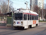
SEPTA's Subway-Surface Trolley Route 36 (a.k.a.; the Elmwood Avenue-Subway Line) is a trolley
line operated by the Southeastern Pennsylvania Transportation Authority (SEPTA) that connects the 13th Street
in downtown Philadelphia, Pennsylvania
, to the Eastwick Loop station in Eastwick
section of Southwest Philadelphia
, although limited service is available to the Elmwood Carhouse. It is the longest of the five lines that are part of the Subway-Surface Trolley system, and was even longer between 1956 and 1962 when the western terminus was at 94th and Eastwick Place. From 1962 through the 1970's it was at 88th Street and Eastwick Place, making the route 16.2 miles (26.1 km) long. Today, it only goes as far as 80th Street.
, Route 36 runs in a tunnel under Market Street
. It stops at underground stations at 15th Street
, 19th Street
, 22nd Street
, 30th Street
, and 33rd Street
. From 15th to 30th Streets, it runs on the outer tracks in the same tunnel as SEPTA's Market–Frankford Line.
Passengers may transfer free of charge to the Market–Frankford Line at 13th, 15th, and 30th Streets and to the Broad Street Line
at 15th Street. Connections to the SEPTA Regional Rail
are also available. Underground passageways connect the 13th and 15th Street Stations to Market East Station and Suburban Station.
Route 36 surfaces at the 40th Street Portal near 40th Street and Baltimore Avenue
(US 13
), and then runs southwest along Woodland Avenue along with the Route 11
trolleys, and then turn down 49th Street where the Woodland Maintenance Facility is located and the Route 10
diversion line ends. After 49th Street crosses over the Wilmington/Newark Line, it takes a sharp right curve as the road becomes Gray's Avenue. Route 36 runs along Gray's south of the Wilmington/Newark Line until it makes a diagonal move southwest onto Lindbergh Boulevard. Shortly aftet leaving Gray's the line intersects with 54th Street and crosses over a bridge for the Philadelphia Subdivision freight line, and immediately intersects with a road running along the line leading to Bartram's Botanical Garden
, the oldest surviving botanical garden in North America.
Just before Lindbergh Boulevard becomes a divided highway east of 56th Street, the line moves onto Elmwood Avenue. From there it crosses over the Airport Line, continuing westward until it enters an industrial area and makes a left turn at a five way intersection that includes Elmwood Avenue, Island Road and Passyunk Avenue on the southeast corner. The northeast corner is the location of the Elmwood Depot
on Island Road. Tracks runs northward along Island Road as far north as Woodland Avenue, which handles pull-ins/pull-outs for the Route 11 line.
Island Road is a wide boulevard with the Route 36 tracks down the middle, until the road divides at Buist Avenue, where the tracks run down the median, and an unofficial trolley stop exists. Another stop exists at Tanager Place. South of Tanager Place, the southbound Island Avenue lane crosses over the tracks, and they now run between the main road and southbound frontage road. The next stop is South 76th Street, which intersects with the frontage road, but has a stop along both this and the main road. The Route 36 line crosses Lindbergh Boulevard again, where it has its own stop on both the northwest and southwest corners of the intersection. The southwest corner also includes the Penrose Plaza Shopping Center, which spans the west side of Island Road as far down as the terminus of the Route 36 line; The Eastwick Loop, which is accessible from a U-Turn beneath the Island Road bridge over the SEPTA Airport Line, and is four blocks east of Eastwick Railroad Station
. SEPTA plans to expand the regional rail station and possibly merge it with the trolley station, transforming it into the Eastwick Transportation Center.
Tram
A tram is a passenger rail vehicle which runs on tracks along public urban streets and also sometimes on separate rights of way. It may also run between cities and/or towns , and/or partially grade separated even in the cities...
line operated by the Southeastern Pennsylvania Transportation Authority (SEPTA) that connects the 13th Street
13th Street (SEPTA station)
13th Street is a SEPTA Market-Frankford Line and Subway-Surface Lines station in Philadelphia, Pennsylvania, under Market Street between 13th and Juniper Streets in Center City. The station serves the Market–Frankford Line and as the terminus for all five routes of the Subway–Surface Trolley Lines...
in downtown Philadelphia, Pennsylvania
Philadelphia, Pennsylvania
Philadelphia is the largest city in the Commonwealth of Pennsylvania and the county seat of Philadelphia County, with which it is coterminous. The city is located in the Northeastern United States along the Delaware and Schuylkill rivers. It is the fifth-most-populous city in the United States,...
, to the Eastwick Loop station in Eastwick
Eastwick, Philadelphia, Pennsylvania
Eastwick is a neighborhood in the Southwest section of Philadelphia, Pennsylvania, United States. It is the southwesternmost neighborhood in the city, bordering Philadelphia International Airport and the city line with Delaware County, Pennsylvania at Cobbs Creek and Darby Creek. The Elmwood Park...
section of Southwest Philadelphia
Southwest Philadelphia
Southwest Philadelphia is a section of Philadelphia, Pennsylvania, United States. The section can be described as extending from the western side of the Schuylkill River to the city line, with the SEPTA Media/Elwyn Line serving as the northern border...
, although limited service is available to the Elmwood Carhouse. It is the longest of the five lines that are part of the Subway-Surface Trolley system, and was even longer between 1956 and 1962 when the western terminus was at 94th and Eastwick Place. From 1962 through the 1970's it was at 88th Street and Eastwick Place, making the route 16.2 miles (26.1 km) long. Today, it only goes as far as 80th Street.
Route description
Starting from its eastern end at the 13th Street13th Street (SEPTA station)
13th Street is a SEPTA Market-Frankford Line and Subway-Surface Lines station in Philadelphia, Pennsylvania, under Market Street between 13th and Juniper Streets in Center City. The station serves the Market–Frankford Line and as the terminus for all five routes of the Subway–Surface Trolley Lines...
, Route 36 runs in a tunnel under Market Street
Market Street (Philadelphia)
Market Street, originally known as High Street, is a major east–west street in Philadelphia, Pennsylvania. For the majority of its length, it serves as Pennsylvania Route 3....
. It stops at underground stations at 15th Street
15th Street (SEPTA station)
15th Street is a rapid transit station on the SEPTA Market–Frankford Line and all routes of the Subway–Surface trolley lines in Philadelphia, Pennsylvania. A free interchange is available between all of the rapid transit lines here, including the Broad Street Line at City Hall, which is connected...
, 19th Street
19th Street (SEPTA station)
19th Street is a subway station of all routes of the SEPTA Subway-Surface Trolley Lines in Center City Philadelphia. It is located underneath Market Street.Touches of the original 1907 station, such as columns and railings, still remain...
, 22nd Street
22nd Street (SEPTA station)
22nd Street is an underground tram station for the SEPTA Subway–Surface Trolley Lines, in Center City, Philadelphia. Similar to 19th Street Station, the station has two side platforms with a total of four tracks. Only the two outer tracks serve the station; the two inner tracks are used for the...
, 30th Street
30th Street (SEPTA station)
30th Street is a rapid transit and trolley station on SEPTA's Market–Frankford and Subway–Surface lines in Philadelphia, Pennsylvania. The station is located on Market Street between 30th and 31st Streets in the University City neighborhood near Drexel University, and is the first station located...
, and 33rd Street
33rd Street (SEPTA station)
33rd Street is a tram stop on all routes of the SEPTA Subway–Surface Trolley Lines in Philadelphia, Pennsylvania. The station is the last station of the Subway-Surface Lines with all lines before the Route 10 splits away and exits the tunnel at 36th Street. The stop is located on the campus of...
. From 15th to 30th Streets, it runs on the outer tracks in the same tunnel as SEPTA's Market–Frankford Line.
Passengers may transfer free of charge to the Market–Frankford Line at 13th, 15th, and 30th Streets and to the Broad Street Line
Broad Street Line
The Broad Street Line is a rapid transit line operated by the Southeastern Pennsylvania Transportation Authority that runs from Fern Rock Transportation Center in North Philadelphia, Pennsylvania to Pattison Avenue in South Philadelphia...
at 15th Street. Connections to the SEPTA Regional Rail
SEPTA Regional Rail
The SEPTA Regional Rail system consists of commuter rail service on thirteen branches to over 150 active stations in Philadelphia, Pennsylvania, United States and its suburbs. Service on most lines runs from 5:30 AM to midnight...
are also available. Underground passageways connect the 13th and 15th Street Stations to Market East Station and Suburban Station.
Route 36 surfaces at the 40th Street Portal near 40th Street and Baltimore Avenue
Baltimore Pike
thumb|[[SEPTA]]'s [[SEPTA Route 34|Route 34]] streetcar line runs through the 4500 block of Baltimore Avenue in [[West Philadelphia]]The Baltimore Pike was an auto trail in the United States, connecting Baltimore, Maryland with Philadelphia, Pennsylvania....
(US 13
U.S. Route 13 in Pennsylvania
U.S. Route 13 passes through the Philadelphia metropolitan area in the U.S. state of Pennsylvania. The route enters the state from Delaware in Marcus Hook, Delaware County. It continues in a northeasterly direction through Delaware County, passes through Philadelphia, and continues into Bucks...
), and then runs southwest along Woodland Avenue along with the Route 11
SEPTA Route 11
SEPTA's Subway-Surface Trolley Route 11 is a trolley line operated by the Southeastern Pennsylvania Transportation Authority that connects the 13th Street in downtown Philadelphia, Pennsylvania, to Darby Transportation Center in Darby, Pennsylvania...
trolleys, and then turn down 49th Street where the Woodland Maintenance Facility is located and the Route 10
SEPTA Route 10
SEPTA's Subway-Surface Trolley Route 10 is a trolley line operated by the Southeastern Pennsylvania Transportation Authority that connects the 13th Street in downtown Philadelphia, Pennsylvania, to the Overbrook Loop station in Overbrook section of West Philadelphia...
diversion line ends. After 49th Street crosses over the Wilmington/Newark Line, it takes a sharp right curve as the road becomes Gray's Avenue. Route 36 runs along Gray's south of the Wilmington/Newark Line until it makes a diagonal move southwest onto Lindbergh Boulevard. Shortly aftet leaving Gray's the line intersects with 54th Street and crosses over a bridge for the Philadelphia Subdivision freight line, and immediately intersects with a road running along the line leading to Bartram's Botanical Garden
Bartram's Garden
Bartram's Garden which covers is the oldest surviving botanic garden in North America, including an historic botanical garden and arboretum , located on the west bank of the Schuylkill River in Fairmount Park, near the intersection of 54th Street and Lindbergh Boulevard, Philadelphia, Pennsylvania...
, the oldest surviving botanical garden in North America.
Just before Lindbergh Boulevard becomes a divided highway east of 56th Street, the line moves onto Elmwood Avenue. From there it crosses over the Airport Line, continuing westward until it enters an industrial area and makes a left turn at a five way intersection that includes Elmwood Avenue, Island Road and Passyunk Avenue on the southeast corner. The northeast corner is the location of the Elmwood Depot
Elmwood Carhouse (SEPTA station)
The Elmwood Carhouse, also known as Elmwood Loop and Elmwood Avenue Loop, is a storage facility and alternate terminus for the SEPTA Route 36 Subway-Surface Trolley Line, in the Elmwood Park section of West Philadelphia...
on Island Road. Tracks runs northward along Island Road as far north as Woodland Avenue, which handles pull-ins/pull-outs for the Route 11 line.
Island Road is a wide boulevard with the Route 36 tracks down the middle, until the road divides at Buist Avenue, where the tracks run down the median, and an unofficial trolley stop exists. Another stop exists at Tanager Place. South of Tanager Place, the southbound Island Avenue lane crosses over the tracks, and they now run between the main road and southbound frontage road. The next stop is South 76th Street, which intersects with the frontage road, but has a stop along both this and the main road. The Route 36 line crosses Lindbergh Boulevard again, where it has its own stop on both the northwest and southwest corners of the intersection. The southwest corner also includes the Penrose Plaza Shopping Center, which spans the west side of Island Road as far down as the terminus of the Route 36 line; The Eastwick Loop, which is accessible from a U-Turn beneath the Island Road bridge over the SEPTA Airport Line, and is four blocks east of Eastwick Railroad Station
Eastwick (SEPTA station)
Eastwick is a station along the Airport Line to Philadelphia International Airport. It is within walking distance of the Eastwick Loop of the 36 trolley which is located at Bartram Avenue near 84th Street...
. SEPTA plans to expand the regional rail station and possibly merge it with the trolley station, transforming it into the Eastwick Transportation Center.