

Roose (hundred)
Encyclopedia
Pembrokeshire
Pembrokeshire is a county in the south west of Wales. It borders Carmarthenshire to the east and Ceredigion to the north east. The county town is Haverfordwest where Pembrokeshire County Council is headquartered....
, Wales
Wales
Wales is a country that is part of the United Kingdom and the island of Great Britain, bordered by England to its east and the Atlantic Ocean and Irish Sea to its west. It has a population of three million, and a total area of 20,779 km²...
. It was formed by the Act of Union
Laws in Wales Acts 1535-1542
The Laws in Wales Acts 1535 and 1542 were parliamentary measures by which the legal system of Wales was annexed to England and the norms of English administration introduced. The intention was to create a single state and a single legal jurisdiction; frequently referred to as England and Wales...
of 1536 and was essentially identical to the pre-Norman cantref of Rhos. It derives its Welsh
Welsh language
Welsh is a member of the Brythonic branch of the Celtic languages spoken natively in Wales, by some along the Welsh border in England, and in Y Wladfa...
name from its position nearly surrounded by water, bounded east by the tidal Western Cleddau
River Cleddau
The River Cleddau consists of the Eastern and Western Cleddau rivers in Pembrokeshire, west Wales. They unite to form the Daugleddau estuary, which forms the important harbour of Milford Haven....
, south by Milford Haven
Milford Haven (harbour)
Milford Haven Waterway is a natural harbour in Pembrokeshire, West Wales. The Haven is a ria or drowned valley flooded at the end of the last Ice Age. formed by the Pembroke River and the Daugleddau estuary, and winds west to the sea...
and west by St Brides Bay
St Bride's Bay
St Brides Bay is a rocky bay inlet in western Pembrokeshire, West Wales.Either Skomer Island or the mainland extremity of Wooltack Point at the western end of the Marloes Peninsula marks the southern limit of the bay whilst its northern limit is marked by Ramsey Island off St Davids Head...
. Rhos locally means (among other things) "promontory". The English form is a corruption of the Welsh. Its area was around 264 km2.
The pre-Norman history of the cantref is uncertain, as is the site of its civil headquarters.: It had been popularly assumed that the chief town of Haverfordwest
Haverfordwest
Haverfordwest is the county town of Pembrokeshire, Wales and serves as the County's principal commercial and administrative centre. Haverfordwest is the most populous urban area in Pembrokeshire, with a population of 13,367 in 2001; though its community boundaries make it the second most populous...
does not pre-date the Norman conquest. However archaeological discoveries in Pembrokeshire as early as the 1920s by Sir Mortimer Wheeler at Wolfscastle earlier Iron Age and Roman coinage and artefact discoveries, and recent excavations by the Dyfed Archaeological Trust under the direction of Heather James at Carmarthen (Maridunum) in the 1980s point convincingly to Roman penetration to the Westernmost parts of Wales. A Roman road running west of Carmarthen has been identified with the possibility of Roman Fortlets at Whitland and Haverfordwest. The strategic position of Haverfordwest with its defensive bluff overlooking the lowest fordable point on the Western Cleddau accessible to sea traffic suggest a Roman origin probably modest in scale for the town from about 96 AD. The ecclesiastical centre (perhaps the seat of a bishop in the Age of the Saints) was probably one of the several churches of the local St Ismael, most probably St. Ishmael's
St. Ishmael's
St Ishmael's is a village and community close to the harbour of Milford Haven in Pembrokeshire, Wales.The community comprises most of the parish of St. Ishmael's and had a population of 490 at the 2001 census. The ward includes the communities of Herbrandston, Dale and Marloes and St. Brides, and...
.
The hundred, with its capital at Haverfordwest was the original centre of the Norman
Normans
The Normans were the people who gave their name to Normandy, a region in northern France. They were descended from Norse Viking conquerors of the territory and the native population of Frankish and Gallo-Roman stock...
/English "plantation" in the 12th century, and it has been essentially English-speaking since then, forming the core of Little England beyond Wales
Little England beyond Wales
Little England beyond Wales is a name applied to an area of southern Pembrokeshire and southwestern Carmarthenshire in Wales, which has been English in language and culture for many centuries despite its remoteness from the English border...
.
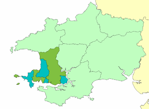
The cantref was said in the post-Norman period to be divided into two or perhaps three commotes. The Red Book of Hergest
Red Book of Hergest
The Red Book of Hergest is a large vellum manuscript written shortly after 1382, which ranks as one of the most important medieval manuscripts written in the Welsh language. It preserves a collection of Welsh prose and poetry, notably the tales of the Mabinogion, Gogynfeirdd poetry...
mentions Hwlffordd (Haverfordwest) commote and Castell Gwalchmei (Walwyn's Castle) commote. The former is an English name, and the "commotes" correspond to the Norman lordships. The northern part of Hwlffordd commote was sometimes distinguished as Roch commote (a French name). None of these is likely to be a real native Welsh subdivision, and the small Cantref of Rhos was probably not actually divided into commotes. The fragmentary Norman lordships are shown in the map.