
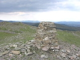
Rhobell Fawr
Encyclopedia
Rhobell Fawr is an extinct volcano in the Arenig
range within the Snowdonia National Park.
Despite its modest height of 734 m (2,408 feet), it is a mountain
with views of higher peaks all around, including the north face of Cadair Idris
and distant Snowdon
.
The paths are not well trodden, but there is a distinct path up from Bwlch Goriwared, a couple of miles north-north-east of the small village of Llanfachreth
. From the pass a ladder-stile crosses a wall beside some sheep-folds on the eastern side of the track. A path follows a wall eastwards for a little more than 2 miles to the summit. The walk can easily be done, there and back from Llanfachreth, in 4 hours, given good weather, and provided you are used to the British mountains and reasonably fit.
A more arduous ascent is a circuit starting at Cwm yr Allt-lwyd. A good path crosses the infant Afon Mawddach, a switchback rises high above the river and then drops to ford it, from where a fence is followed to the neighbouring summit of Dduallt
. From there, descend to the forest
, which is entered at a corner . The forest is extremely dense, but soon a firebreak is reached and this is followed until a forestry track is seen at the edge of the forest . Follow this track south-west to a wall , turn right and stay by the wall all the way to the summit. The descent is arduous and involves much struggling through heather
and bog until finally a path is picked up. The whole walk should take about six hours.
Arenig
In geology, the Arenigian refers both to a time interval during the Lower Ordovician period and also to the suite of rocks which were deposited during this interval.-History:...
range within the Snowdonia National Park.
Despite its modest height of 734 m (2,408 feet), it is a mountain
Mountain
Image:Himalaya_annotated.jpg|thumb|right|The Himalayan mountain range with Mount Everestrect 58 14 160 49 Chomo Lonzorect 200 28 335 52 Makalurect 378 24 566 45 Mount Everestrect 188 581 920 656 Tibetan Plateaurect 250 406 340 427 Rong River...
with views of higher peaks all around, including the north face of Cadair Idris
Cadair Idris
Cadair Idris or Cader Idris is a mountain in Gwynedd, Wales that lies at the southern end of the Snowdonia National Park. The peak, which is one of the most popular in Wales for walkers and hikers, is composed largely of Ordovician igneous rocks, with classic glacial erosion features such as...
and distant Snowdon
Snowdon
Snowdon is the highest mountain in Wales, at an altitude of above sea level, and the highest point in the British Isles outside Scotland. It is located in Snowdonia National Park in Gwynedd, and has been described as "probably the busiest mountain in Britain"...
.
The paths are not well trodden, but there is a distinct path up from Bwlch Goriwared, a couple of miles north-north-east of the small village of Llanfachreth
Llanfachreth
Llanfachreth is a settlement some three miles North East of Dolgellau in the former county of Merionethshire ., Mid Wales. The village is on the slopes of the valley of the river Mawddach and at the foot of Moel Orthrwm...
. From the pass a ladder-stile crosses a wall beside some sheep-folds on the eastern side of the track. A path follows a wall eastwards for a little more than 2 miles to the summit. The walk can easily be done, there and back from Llanfachreth, in 4 hours, given good weather, and provided you are used to the British mountains and reasonably fit.
A more arduous ascent is a circuit starting at Cwm yr Allt-lwyd. A good path crosses the infant Afon Mawddach, a switchback rises high above the river and then drops to ford it, from where a fence is followed to the neighbouring summit of Dduallt
Dduallt
Dduallt is a mountain in central Snowdonia, North Wales. It is the sister peak of Rhobell Fawr.It lies north of the A494 between Dolgellau and Llanuwchllyn. Its eastern slopes are the source of the River Dee.-External links:* Dduallt is at coordinates *...
. From there, descend to the forest
Forest
A forest, also referred to as a wood or the woods, is an area with a high density of trees. As with cities, depending where you are in the world, what is considered a forest may vary significantly in size and have various classification according to how and what of the forest is composed...
, which is entered at a corner . The forest is extremely dense, but soon a firebreak is reached and this is followed until a forestry track is seen at the edge of the forest . Follow this track south-west to a wall , turn right and stay by the wall all the way to the summit. The descent is arduous and involves much struggling through heather
Calluna
Calluna vulgaris is the sole species in the genus Calluna in the family Ericaceae. It is a low-growing perennial shrub growing to tall, or rarely to and taller, and is found widely in Europe and Asia Minor on acidic soils in open sunny situations and in moderate shade...
and bog until finally a path is picked up. The whole walk should take about six hours.