

Retsof, New York
Encyclopedia
Retsof is an unincorporated community (hamlet
) within the town of York
in Livingston County, New York
, United States
. The community, situated 26 miles (41.8 km) southwest of the city of Rochester
, is roughly centered around the junction between New York State Route 36
and New York State Route 63
.
 It was founded by a man named Foster who reversed the letters of his name to name the town and was the site of one of the world's largest salt mine
s until its collapse in 1994. A new mine, the Hampton Corners mine, is located near Mount Morris
, about 10 miles (16.1 km) to the southeast.
The original population of Retsof was mostly of Italian origin; they lived in a company town where the salt mine owned the houses and a store and maintained the small village.
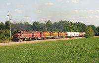
In addition to the salt mine, there was a small railroad—the Genesee and Wyoming Railroad
(G&W)—that took the salt to the "Main Lines" in neighboring towns. The G&W remains active today as a branch line of the Rochester and Southern Railroad
.
, leaving many drinking water wells dry, and led to surface subsidence
, even sinkholes 200 feet (61 m) wide, damaging structures and highways. 8 feet (2.4 m) or 9 feet (2.7 m) of additional subsidence is expected to take place over the next century.
USGS studied effects of mine collapse on groundwater hydology.
Hamlet (place)
A hamlet is usually a rural settlement which is too small to be considered a village, though sometimes the word is used for a different sort of community. Historically, when a hamlet became large enough to justify building a church, it was then classified as a village...
) within the town of York
York, New York
York is a town in western Livingston County, New York, United States. The population was 3,219 at the 2000 census.The Abbey of the Genesee in the town's hamlet of Piffard is locally famous due to the production of Monk's Bread.- History :...
in Livingston County, New York
Livingston County, New York
As of the census of 2000, there were 64,328 people, 22,150 households, and 15,349 families residing in the county. The population density was 102 people per square mile . There were 24,023 housing units at an average density of 38 per square mile...
, United States
United States
The United States of America is a federal constitutional republic comprising fifty states and a federal district...
. The community, situated 26 miles (41.8 km) southwest of the city of Rochester
Rochester, New York
Rochester is a city in Monroe County, New York, south of Lake Ontario in the United States. Known as The World's Image Centre, it was also once known as The Flour City, and more recently as The Flower City...
, is roughly centered around the junction between New York State Route 36
New York State Route 36
New York State Route 36 is a north–south state highway in the western part of New York in the United States. The highway extends for from the Pennsylvania state line at Troupsburg, Steuben County northward to Ogden, Monroe County, where it ends at an intersection with NY 31...
and New York State Route 63
New York State Route 63
New York State Route 63 is a state highway in the western part of New York in the United States. The southern terminus of the route is at an intersection with NY 15 and NY 21 in the village of Wayland in Steuben County. Its northern end is at a junction with NY 18 in the town...
.
Salt mine
A salt mine is a mining operation involved in the extraction of rock salt or halite from evaporite deposits.-Occurrence:Areas known for their salt mines include Kilroot near Carrickfergus, Northern Ireland ; Khewra and Warcha in Pakistan; Tuzla in Bosnia; Wieliczka and Bochnia in Poland A salt mine...
s until its collapse in 1994. A new mine, the Hampton Corners mine, is located near Mount Morris
Mount Morris (village), New York
Mount Morris is a village located in the Town of Mount Morris in Livingston County, New York, USA. The population was 3,266 at the 2000 census. The village and town are named after Robert Morris....
, about 10 miles (16.1 km) to the southeast.
The original population of Retsof was mostly of Italian origin; they lived in a company town where the salt mine owned the houses and a store and maintained the small village.
In addition to the salt mine, there was a small railroad—the Genesee and Wyoming Railroad
Genesee and Wyoming Railroad
Genesee & Wyoming Inc. is a short-line railroad holding company that owns or maintains interests in 63 railroads throughout six countries , and operates more than of owned and leased track, with more than under additional track-access arrangements...
(G&W)—that took the salt to the "Main Lines" in neighboring towns. The G&W remains active today as a branch line of the Rochester and Southern Railroad
Rochester and Southern Railroad
The Rochester and Southern Railroad , a subsidiary of Genesee & Wyoming Inc., is a class III shortline that runs from the city of Rochester in Monroe County to Silver Springs, NY. The RSR started in 1986, when the B&O sold off its Buffalo and Rochester branches...
.
Retsof Salt Mine
In 1994, the Retsof Salt Mine was the largest salt mine in North America, and the second largest in the world. Three hundred people worked within the 6000 acre (24.3 km²; 9.4 sq mi) of excavated space, 1000 feet (304.8 m) below ground, extracting salt from a natural deposit for use as road salt, table salt, and in industry. In March 1994, however, the ceiling in one of the large underground chambers collapsed, the first of a series of effects caused by groundwater entering the salt deposit, which had been dry for all of the 110 previous years of mining at the site. Over the next 21 months, the mine cavities collapsed and filled with water. Mining operations scrambled to work the accessible areas before the spreading flood, until operations were suspended when the mine was fully filled with water, in 1995. The effect of filling all this space lowered the aquiferAquifer
An aquifer is a wet underground layer of water-bearing permeable rock or unconsolidated materials from which groundwater can be usefully extracted using a water well. The study of water flow in aquifers and the characterization of aquifers is called hydrogeology...
, leaving many drinking water wells dry, and led to surface subsidence
Subsidence
Subsidence is the motion of a surface as it shifts downward relative to a datum such as sea-level. The opposite of subsidence is uplift, which results in an increase in elevation...
, even sinkholes 200 feet (61 m) wide, damaging structures and highways. 8 feet (2.4 m) or 9 feet (2.7 m) of additional subsidence is expected to take place over the next century.
USGS studied effects of mine collapse on groundwater hydology.