
Reid-Hillview Airport of Santa Clara County
Encyclopedia
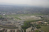
Reid-Hillview Airport of Santa Clara County is located in the eastern part of San Jose
, south of San Francisco Bay
, in Santa Clara County
, California
, USA
. The airport is owned by Santa Clara County.
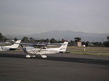
Reid-Hillview is a general aviation
airport; there is no scheduled airline service. However, as with most general aviation airports air charter
operations are available. The airport has a control tower
that operates 7 a.m. to 10 p.m. local time. The FAA
classifies Reid-Hillview as a reliever airport for San Jose International Airport
, providing public access via general aviation to the San Jose area while separating the faster and slower traffic to different airports.
. Their second site was northwest of the Hillview golf course, hence the name. Until 1946, the single runway at the airport was unpaved.
Reid-Hillview was a single runway airport until 1965, when a second runway was added. The control tower was added in October 1967.
The airport became the origin for an emergency supply airlift to the Watsonville Municipal Airport
following the 1989 Loma Prieta earthquake, after mountain and coastal roads were blocked, cutting off Santa Cruz
and Watsonville
from relief efforts by ground. The Watsonville Airport estimates that it received 100 tons of supplies via the airlift during the week following the quake. John McAvoy and Bill Dunn of the Reid-Hillview Airport Association received the 1990 Grand Award from the Bay Area's Metropolitan Transportation Commission
for organizing the airlift.
In 2010, San Jose State University
's Aviation program relocated to Reid-Hillview. The University operates out of the Swift Building, where it holds classes during the academic year.
compete for fuel sales, aircraft rentals and/or flight training.
Rental cars (Enterprise) are located in the same building with the Airport Shoppe at the airport entrance.
(VTA) has its Eastridge Transit Center
across Tully Road at Eastridge Mall
, about 1/2 mile walk southbound along Capitol Expressway. For transit options, see a Google Transit search starting from Reid-Hillview Airport.
VTA has future plans for a bus rapid transit
line from the Diridon train station
in downtown San Jose to the Eastridge Transit Center
. Further distant future plans with less certain funding include a light rail extension from the Alum Rock station
to Eastridge. In both cases, the segment along Capitol Expressway would serve Reid-Hillview.
San Jose, California
San Jose is the third-largest city in California, the tenth-largest in the U.S., and the county seat of Santa Clara County which is located at the southern end of San Francisco Bay...
, south of San Francisco Bay
San Francisco Bay
San Francisco Bay is a shallow, productive estuary through which water draining from approximately forty percent of California, flowing in the Sacramento and San Joaquin rivers from the Sierra Nevada mountains, enters the Pacific Ocean...
, in Santa Clara County
Santa Clara County, California
Santa Clara County is a county located at the southern end of the San Francisco Bay Area in the U.S. state of California. As of 2010 it had a population of 1,781,642. The county seat is San Jose. The highly urbanized Santa Clara Valley within Santa Clara County is also known as Silicon Valley...
, California
California
California is a state located on the West Coast of the United States. It is by far the most populous U.S. state, and the third-largest by land area...
, USA
United States
The United States of America is a federal constitutional republic comprising fifty states and a federal district...
. The airport is owned by Santa Clara County.
Reid-Hillview is a general aviation
General aviation
General aviation is one of the two categories of civil aviation. It refers to all flights other than military and scheduled airline and regular cargo flights, both private and commercial. General aviation flights range from gliders and powered parachutes to large, non-scheduled cargo jet flights...
airport; there is no scheduled airline service. However, as with most general aviation airports air charter
Air charter
Air charter is the business of renting an entire aircraft as opposed to individual aircraft seats...
operations are available. The airport has a control tower
Control tower
A control tower, or more specifically an Air Traffic Control Tower , is the name of the airport building from which the air traffic control unit controls the movement of aircraft on and around the airport. Control towers are also used to control the traffic for other forms of transportation such...
that operates 7 a.m. to 10 p.m. local time. The FAA
Federal Aviation Administration
The Federal Aviation Administration is the national aviation authority of the United States. An agency of the United States Department of Transportation, it has authority to regulate and oversee all aspects of civil aviation in the U.S...
classifies Reid-Hillview as a reliever airport for San Jose International Airport
San Jose International Airport
Norman Y. Mineta San Jose International Airport is a city-owned public-use airport serving the city of San Jose in Santa Clara County, California, United States. It is named for San Jose native Norman Yoshio Mineta, who was Transportation Secretary in the Cabinet of George W...
, providing public access via general aviation to the San Jose area while separating the faster and slower traffic to different airports.
History
Groundbreaking for Reid-Hillview airport came in 1937. Bob and Cecil Reid first built the Garden City Airport in 1935, which was quickly closed to make room for U.S. Route 101U.S. Route 101
U.S. Route 101, or U.S. Highway 101, is an important north–south U.S. highway that runs through the states of California, Oregon, and Washington, on the West Coast of the United States...
. Their second site was northwest of the Hillview golf course, hence the name. Until 1946, the single runway at the airport was unpaved.
Reid-Hillview was a single runway airport until 1965, when a second runway was added. The control tower was added in October 1967.
The airport became the origin for an emergency supply airlift to the Watsonville Municipal Airport
Watsonville Municipal Airport
Watsonville Municipal Airport is a public airport located three miles northwest of the central business district of Watsonville, a city in Santa Cruz County, California, USA. The airport covers and has two runways...
following the 1989 Loma Prieta earthquake, after mountain and coastal roads were blocked, cutting off Santa Cruz
Santa Cruz, California
Santa Cruz is the county seat and largest city of Santa Cruz County, California in the US. As of the 2010 U.S. Census, Santa Cruz had a total population of 59,946...
and Watsonville
Watsonville, California
Watsonville is a city in Santa Cruz County, California, United States. The population was 51,199 according to the 2010 census.Located on the central coast of California, the economy centers predominantly around the farming industry. It is known for growing strawberries, apples, lettuce and a host...
from relief efforts by ground. The Watsonville Airport estimates that it received 100 tons of supplies via the airlift during the week following the quake. John McAvoy and Bill Dunn of the Reid-Hillview Airport Association received the 1990 Grand Award from the Bay Area's Metropolitan Transportation Commission
Metropolitan Transportation Commission (San Francisco Bay Area)
The Metropolitan Transportation Commission is a regional planning, financing, and funding government agency in the San Francisco Bay Area. It was created in 1970 to coordinate the transit systems in the area's nine counties...
for organizing the airlift.
In 2010, San Jose State University
San José State University
San Jose State University is a public university located in San Jose, California, United States...
's Aviation program relocated to Reid-Hillview. The University operates out of the Swift Building, where it holds classes during the academic year.
Fixed base operators
At Reid-Hillview, fixed base operators (FBOs)Fixed base operator
A Fixed-base operator or commonly abbreviated FBO is a term developed in the United States after the passage of the Air Commerce Act of 1926...
compete for fuel sales, aircraft rentals and/or flight training.
- Air Accord
- AeroDynamic Aviation, formerly Amelia ReidAmelia ReidAmelia Reid was a pilot, flight instructor, businesswoman, airshow performer and airport advocate.In 1960 Reid founded Amelia Reid Aviation, a flight school at Reid-Hillview Airport in San Jose, California. She ran the business out of her 1959 Ford and later, two trailers...
Aviation - Nice Air Aviation
- Squadron 2 Flying Club
- Trade Winds Aviation
- Aerial Avionics
Ground transportation
Capitol Expressway (County Route G21) is at the entrance to the airport at Cunningham Ave.Car/taxi
Taxis are not located on-field. They may be dispatched by phone to the terminal building.Rental cars (Enterprise) are located in the same building with the Airport Shoppe at the airport entrance.
Bus
The Santa Clara Valley Transportation AuthoritySanta Clara Valley Transportation Authority
The Santa Clara Valley Transportation Authority is a special-purpose district responsible for public transit services, congestion management, specific highway improvement projects, and countywide transportation planning for Santa Clara County, California, United States...
(VTA) has its Eastridge Transit Center
Eastridge Transit Center
The Santa Clara Valley Transportation Authority Eastridge Transit Center is a transit bus station located at Eastridge Mall in eastern San Jose, California...
across Tully Road at Eastridge Mall
Eastridge Center
Eastridge Center is a shopping mall in eastern San Jose, California owned by General Growth Properties. The mall has an enclosed shopping area, restaurants and theaters...
, about 1/2 mile walk southbound along Capitol Expressway. For transit options, see a Google Transit search starting from Reid-Hillview Airport.
VTA has future plans for a bus rapid transit
Bus rapid transit
Bus rapid transit is a term applied to a variety of public transportation systems using buses to provide faster, more efficient service than an ordinary bus line. Often this is achieved by making improvements to existing infrastructure, vehicles and scheduling...
line from the Diridon train station
Diridon Station
Diridon Station is the central passenger rail depot for San Jose, California. It also serves as a transit hub for Santa Clara County and the Silicon Valley...
in downtown San Jose to the Eastridge Transit Center
Eastridge Transit Center
The Santa Clara Valley Transportation Authority Eastridge Transit Center is a transit bus station located at Eastridge Mall in eastern San Jose, California...
. Further distant future plans with less certain funding include a light rail extension from the Alum Rock station
Alum Rock (VTA)
Alum Rock Transit Center is a light rail and bus station operated by Santa Clara Valley Transportation Authority . This station is served by VTA's Alum Rock–Santa Teresa line.The station was opened in 2004 as part of VTA's Capitol light rail extension....
to Eastridge. In both cases, the segment along Capitol Expressway would serve Reid-Hillview.
See also
- List of attractions in Silicon Valley
- San Jose International AirportSan Jose International AirportNorman Y. Mineta San Jose International Airport is a city-owned public-use airport serving the city of San Jose in Santa Clara County, California, United States. It is named for San Jose native Norman Yoshio Mineta, who was Transportation Secretary in the Cabinet of George W...
- Palo Alto Airport
- South County AirportSouth County AirportSouth County Airport of Santa Clara County, colloquially South County Airport, is a public non-towered airport located one mile east of San Martin, serving Santa Clara County, California, U.S.A. This general aviation airport covers and has one runway. A self-service fueling facility offers...
- Alum Rock AirportAlum Rock AirportThe Alum Rock Airport was an early airport in the town of Alum Rock, California. It was in an area now in the city limits of San Jose near the intersection of Alum Rock Avenue and Capitol Avenue. The airport was established in 1919 by Reserve Lieutenant Johnny Johnston after returning from World...
, historical airport nearby in Alum Rock from 1919 to approximately 1936 - Amelia ReidAmelia ReidAmelia Reid was a pilot, flight instructor, businesswoman, airshow performer and airport advocate.In 1960 Reid founded Amelia Reid Aviation, a flight school at Reid-Hillview Airport in San Jose, California. She ran the business out of her 1959 Ford and later, two trailers...
External links
- Reid-Hillview Airport (official site)
- The Airport Shoppe - On-field pilot supplies
- Reid-Hillview Airport Association
- Experimental Aircraft Association (EAA) Chapter 62 - Local chapter of the Experimental Aircraft AssociationExperimental Aircraft AssociationThe Experimental Aircraft Association is an international organization of aviation enthusiasts based in Oshkosh, Wisconsin. Since its inception it has grown internationally with over 160,000 members and about 1,000 chapters worldwide....
- Santa Clara Valley Chapter of Ninety-Nines - Local chapter of the Ninety-Nines International organization for women pilots
- Civil Air PatrolCivil Air PatrolCivil Air Patrol is a Congressionally chartered, federally supported, non-profit corporation that serves as the official civilian auxiliary of the United States Air Force . CAP is a volunteer organization with an aviation-minded membership that includes people from all backgrounds, lifestyles, and...
Squadrons based at RHV: search & rescue, aerospace education- Squadron 80 - Senior squadron, adult volunteers
- Squadron 36 - Cadet squadron, youth volunteers
- Take Flight for Kids - A charity that gives rides to disabled children in private aircraft
- live webcam at AeroDynamic Aviation
- GaryAir - Air taxi service
- Photos and video
- Approval Of Noise Compatibility Program for Reid-Hillview Airport, San Jose, CA at Environmental Protection AgencyUnited States Environmental Protection AgencyThe U.S. Environmental Protection Agency is an agency of the federal government of the United States charged with protecting human health and the environment, by writing and enforcing regulations based on laws passed by Congress...