
Regions of Nunavut
Encyclopedia
The regions of Nunavut serve as census division
s, although Statistics Canada has tended to use the names "Baffin Region" for Qikiqtaaluk Region and "Keewatin Region" for Kivalliq Region. Though the regions have no autonomous governments, Nunavut's territorial government services are highly decentralized on a regional basis. The Qikiqtaaluk or Baffin Region is the largest region in Canada, while the Kitikmeot Region
is the second least densely populated.
It is a misconception that Nunavut
is made up of some of the former regions
of the Northwest Territories
, separated in their entirety. This is not the case; the dividing line did not follow region boundaries, although boundaries have been subsequently finessed so that three former NWT regions collectively constitute Nunavut.
The regional divisions are distinct from the district system of dividing the Northwest Territories that dated to 1876 and was abolished when Nunavut was created. Nunavut encompasses the entirety of the District of Keewatin
(which had differing boundaries from the Keewatin/Kivalliq regions), the majority of the District of Franklin
and a small portion of the District of Mackenzie
.
Census division
Census division is an official term in Canada and the United States. The census divisions of Canada are second-level census geographic unit, below provinces and territories, and above "census subdivisions" and "dissemination areas". In provinces where they exist, the census division may correspond...
s, although Statistics Canada has tended to use the names "Baffin Region" for Qikiqtaaluk Region and "Keewatin Region" for Kivalliq Region. Though the regions have no autonomous governments, Nunavut's territorial government services are highly decentralized on a regional basis. The Qikiqtaaluk or Baffin Region is the largest region in Canada, while the Kitikmeot Region
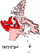
Kitikmeot Region, Nunavut
Kitikmeot Region is an administrative region of Nunavut, Canada. It consists of the southern and eastern parts of Victoria Island with the adjacent part of the mainland as far as the Boothia Peninsula, together with King William Island and the southern portion of Prince of Wales Island...
is the second least densely populated.
It is a misconception that Nunavut
Nunavut
Nunavut is the largest and newest federal territory of Canada; it was separated officially from the Northwest Territories on April 1, 1999, via the Nunavut Act and the Nunavut Land Claims Agreement Act, though the actual boundaries had been established in 1993...
is made up of some of the former regions
Regions of the Northwest Territories
The regions of the Northwest Territories divide the Northwest Territories into two census divisions by Statistics Canada and five administrative regions by the government of the Northwest Territories.-Census divisions with their regional seats:...
of the Northwest Territories
Northwest Territories
The Northwest Territories is a federal territory of Canada.Located in northern Canada, the territory borders Canada's two other territories, Yukon to the west and Nunavut to the east, and three provinces: British Columbia to the southwest, and Alberta and Saskatchewan to the south...
, separated in their entirety. This is not the case; the dividing line did not follow region boundaries, although boundaries have been subsequently finessed so that three former NWT regions collectively constitute Nunavut.
The regional divisions are distinct from the district system of dividing the Northwest Territories that dated to 1876 and was abolished when Nunavut was created. Nunavut encompasses the entirety of the District of Keewatin
District of Keewatin
The District of Keewatin was a territory of Canada and later an administrative district of the Northwest Territories.The name "Keewatin" comes from Algonquian roots—either kīwēhtin in Cree or giiwedin in Ojibwe—both of which mean north wind in their respective languages...
(which had differing boundaries from the Keewatin/Kivalliq regions), the majority of the District of Franklin
District of Franklin
The District of Franklin was a regional administrative district of Canada's Northwest Territories. The district consisted of the Canadian high Arctic Islands, notably Ellesmere Island, Baffin Island, and Victoria Island...
and a small portion of the District of Mackenzie
District of Mackenzie
The District of Mackenzie was a regional administrative district of Canada's Northwest Territories. The district consisted of the portion of the Northwest Territories directly north of British Columbia, Alberta, and Saskatchewan on Canada's mainland....
.
| Region and Postal Code | Kitikmeot Region X0B Kitikmeot Region, Nunavut Kitikmeot Region is an administrative region of Nunavut, Canada. It consists of the southern and eastern parts of Victoria Island with the adjacent part of the mainland as far as the Boothia Peninsula, together with King William Island and the southern portion of Prince of Wales Island... | Kivalliq Region X0C | Qikiqtaaluk Region X0A |
|---|---|---|---|
| (replaced "Kitikmeot Region, NWT Kitikmeot Region, Northwest Territories The Kitikmeot Region was part of the Northwest Territories until division in April 1999 when most of the region became part of Nunavut. It consisted of Victoria Island with the adjacent part of the mainland as far as the Boothia Peninsula, together with King William Island and the southern portion... ") | (replaced "Keewatin Region, NWT Keewatin Region, Northwest Territories The Keewatin Region was a region of the Northwest Territories, in use as an administrative and statistical division until the creation of Nunavut in 1999... ") | (replaced "Baffin Region, NWT Baffin Region, Northwest Territories The Baffin Region was a region of the Northwest Territories, in use as an administrative and statistical division until the creation of Nunavut in 1999. The large majority of Baffin Region fell on the Nunavut side of the boundary and was reconstituted within the new territory as the Qikiqtaaluk... ") | |
| Census division name | Kitikmeot Region | Keewatin Region | Baffin Region |
| Regional seat | Cambridge Bay Cambridge Bay, Nunavut Cambridge Bay, named for Prince Adolphus, Duke of Cambridge, is a hamlet located in the Kitikmeot Region of Nunavut, Canada... | Rankin Inlet | Iqaluit |
| Area (km²) | 446,727.7 | 445,109.37 | 1,040,417.9 |
| Population, 2006 (2001) | 5,361 (4,816) | 8,348 (7,557) | 15,765 (14,372) |
| Population change (2001–2006) | +11.3% | +10.5% | +9.7% |
| Density | 0.012/km² | 0.019/km² | 0.015/km² |
| Map |  | 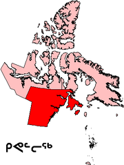 | 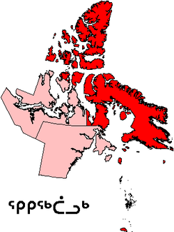 |