
Regional District of Bulkley-Nechako, British Columbia
Encyclopedia
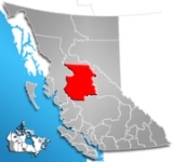
The Regional District of Bulkley-Nechako (RDBN) is a regional district in the Canadian province of British Columbia
, Canada
. As of the 2006 census
, the population
was 38,243. The area
is 73,419.01 square kilometres. The regional district offices are in Burns Lake
.
Its geographical components are the Bulkley Valley
, the northern part of the Nechako Country
, and the Omineca Country
, including portions of the Hazelton Mountains
and Omineca Mountains
in the west and north of the regional district, respectively. The dominant landform is the Nechako Plateau
. Neighbouring regional districts are the Kitimat-Stikine, Central Coast, Cariboo, Fraser-Fort George, and Peace River Regional Districts; on its north the boundary with the southern edge of the remote Stikine Region
is separated from the Bulkley-Nechako Regional District by the 56th parallel north
. The boundaries of the regional district near-entirely coincide with the territory of the Dakelh
or Carrier peoples, and also some of that of the Dunneza
(Beaver), but their reserves and governments lie outside the regional district system. Roughly identical in area to the old New Caledonia fur district
in the days of the North West Company
, it is still sometimes referenced as New Caledonia, but while trapping continues in some area, its economy is now based in forestry, mining, tourism (mostly ranching in southern areas).
British Columbia
British Columbia is the westernmost of Canada's provinces and is known for its natural beauty, as reflected in its Latin motto, Splendor sine occasu . Its name was chosen by Queen Victoria in 1858...
, Canada
Canada
Canada is a North American country consisting of ten provinces and three territories. Located in the northern part of the continent, it extends from the Atlantic Ocean in the east to the Pacific Ocean in the west, and northward into the Arctic Ocean...
. As of the 2006 census
Census
A census is the procedure of systematically acquiring and recording information about the members of a given population. It is a regularly occurring and official count of a particular population. The term is used mostly in connection with national population and housing censuses; other common...
, the population
Population
A population is all the organisms that both belong to the same group or species and live in the same geographical area. The area that is used to define a sexual population is such that inter-breeding is possible between any pair within the area and more probable than cross-breeding with individuals...
was 38,243. The area
Area
Area is a quantity that expresses the extent of a two-dimensional surface or shape in the plane. Area can be understood as the amount of material with a given thickness that would be necessary to fashion a model of the shape, or the amount of paint necessary to cover the surface with a single coat...
is 73,419.01 square kilometres. The regional district offices are in Burns Lake
Burns Lake, British Columbia
thumb|309px|right|Burns Lake's welcome signBurns Lake is a rural village in the North-Central Interior of British Columbia, Canada, incorporated in 1923...
.
Its geographical components are the Bulkley Valley
Bulkley Valley
The Bulkley Valley is located in the northwest Central Interior of British Columbia, Canada.-Geography:The 257 km long Bulkley River runs through the valley which is bounded on the west by the Hudson Bay Mountain range and on the east by the Babine Mountains...
, the northern part of the Nechako Country
Nechako Country
The Nechako Country, also referred to as the Nechako District or simply "the Nechako" is one of the historical geographic regions of the Canadian province of British Columbia, located southwest of the city of Prince George and south of Hwy 16 on the inland side of the Hazelton Mountains The...
, and the Omineca Country
Omineca Country
The Omineca Country, also called the Omineca District or the Omineca, is a historical geographic region of the Northern Interior of British Columbia, roughly defined by the basin of the Omineca River but including areas to the south which allowed access to the region during the Omineca Gold Rush of...
, including portions of the Hazelton Mountains
Hazelton Mountains
The Hazelton Mountains are a grouping of mountain ranges on the inland lee of the Kitimat Ranges of the Coast Mountains in northwestern British Columbia, Canada, spanning the area of Hazelton, British Columbia south to the Nechako Reservoir...
and Omineca Mountains
Omineca Mountains
The Omineca Mountains, also known as "the Ominecas", are a group of remote mountain ranges in north-central British Columbia, Canada. They are bounded by the Finlay River on the north, the Rocky Mountain Trench on the east, the Nation River on the south, and the upper reaches of the Omineca River...
in the west and north of the regional district, respectively. The dominant landform is the Nechako Plateau
Nechako Plateau
The Nechako Plateau is the northernmost subdivision of the Interior Plateau, one of the main geographic regions of the Canadian province of British Columbia...
. Neighbouring regional districts are the Kitimat-Stikine, Central Coast, Cariboo, Fraser-Fort George, and Peace River Regional Districts; on its north the boundary with the southern edge of the remote Stikine Region
Stikine Region
The Stikine Region is an unincorporated area in northwesternmost British Columbia, Canada and is the only area in B.C. not in a regional district...
is separated from the Bulkley-Nechako Regional District by the 56th parallel north
56th parallel north
The 56th parallel north is a circle of latitude that is 56 degrees north of the Earth's equatorial plane. It crosses Europe, Asia, the Pacific Ocean, North America, and the Atlantic Ocean....
. The boundaries of the regional district near-entirely coincide with the territory of the Dakelh
Dakelh
The Dakelh or Carrier are the indigenous people of a large portion of the Central Interior of British Columbia, Canada.Most Carrier call themselves Dakelh, meaning "people who go around by boat"...
or Carrier peoples, and also some of that of the Dunneza
Dunneza
The Dane-zaa are a First Nation of the large Athapaskan language group; their traditional territory is around the Peace River of the provinces of Alberta and British Columbia, Canada...
(Beaver), but their reserves and governments lie outside the regional district system. Roughly identical in area to the old New Caledonia fur district
New Caledonia (Canada)
New Caledonia was the name given to a district of the Hudson's Bay Company that comprised the territory largely coterminous with the present-day province of British Columbia, Canada. Though not a British colony, New Caledonia was part of the British claim to North America. Its administrative...
in the days of the North West Company
North West Company
The North West Company was a fur trading business headquartered in Montreal from 1779 to 1821. It competed with increasing success against the Hudson's Bay Company in what was to become Western Canada...
, it is still sometimes referenced as New Caledonia, but while trapping continues in some area, its economy is now based in forestry, mining, tourism (mostly ranching in southern areas).
| Municipality | Population |
| Smithers Smithers, British Columbia Smithers is a town located in northwestern British Columbia, Canada, approximately halfway between Prince George and Prince Rupert. Smithers is located in the Regional District of Bulkley-Nechako.... |
5,217 |
| Vanderhoof Vanderhoof, British Columbia -External links:**... |
4,064 |
| Houston Houston, British Columbia Houston is a forestry, mining and tourism town in the Bulkley Valley of the Northern Interior of British Columbia, Canada. Its urban population is approximately 3600 people, with approximately 2000 in the surrounding rural area. It is known as the "Steelhead Capital" and it has the world's largest... |
3,163 |
| Burns Lake Burns Lake, British Columbia thumb|309px|right|Burns Lake's welcome signBurns Lake is a rural village in the North-Central Interior of British Columbia, Canada, incorporated in 1923... |
2,107 |
| Fort St. James Fort St. James, British Columbia Fort St. James is a district municipality and former fur trading post in north-central British Columbia, Canada. It is located on the south-eastern shore of Stuart Lake in the Omineca Country, at the northern terminus of Highway 27, which connects to Highway 16 at Vanderhoof... |
1,355 |
| Telkwa Telkwa, British Columbia Telkwa is a village located along British Columbia Highway 16, nearly 15 km southeast of the town of Smithers and 350 km west of the city of Prince George, in northwest British Columbia, Canada.... |
1,295 |
| Fraser Lake Fraser Lake, British Columbia Fraser Lake is a village in northern British Columbia, Canada. It is located on the southwest side of Fraser Lake between Burns Lake and Vanderhoof alongside the Yellowhead Highway.... |
1,113 |
| Granisle Granisle, British Columbia Granisle is a village on Babine Lake in the Northern Interior of British Columbia, Canada, to the north of Topley between Burns Lake and Houston.- History :... |
364 |