
Dakelh
Encyclopedia
The Dakelh or Carrier are the indigenous people
of a large portion of the Central Interior
of British Columbia
, Canada
.
Most Carrier call themselves Dakelh, meaning "people who go around by boat". The term Carrier is a translation of the name for them used by the neighboring Sekani
First Nations
people which Europeans learned first because they crossed Sekani territory before entering Carrier territory. The Dakelh are linguistically Athabaskan
.
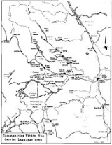
 Traditional Carrier territory includes the area along the Fraser River
from north of Prince George
to south of Quesnel
and including the Barkerville
-Well
s area, the Nechako Country
, the areas around Stuart Lake
, Trembleur Lake, Takla Lake
, Fraser Lake, and Babine Lake
, the Bulkley Valley
, and the region along the West Road River
, west to the Hazelton Mountains
and the Kitimat Ranges
of the Coast Mountains
, including the Kluskus Lakes
, Ootsa Lake, the Quanchus
and Fawnie Ranges, and Cheslatta Lake.
The Carrier region is for the most part sub-boreal forest, dotted with numerous lakes. There are numerous rivers, all ultimately draining into the Pacific Ocean
, mostly via the Fraser River. The climate is continental, with cold winters during which the rivers and lakes freeze over and a short growing season. The area is hilly, with mountains of modest size. The Rocky Mountains
form the eastern boundary of Carrier territory, but Carrier people are not very familiar even with their foothills because that area in recent times has been occupied by the Cree
. Part of the Coast Mountains
and Hazelton Mountains
fall within Witsuwit'en territory. Farther south, Ulkatcho Carrier people share the Coast Range with the Nuxalk
and the northern Chilcotin Plateau
with the Tsilhqot'in
.
, which were smoked and stored for the winter in large numbers. Hunting and trapping of deer
, caribou, moose
, elk
, black bear
, beaver
, and rabbit
provided meat, fur for clothing, and bone for tools. Other fur-bearing animals were trapped to some extent, but until the advent of the fur trade
, such trapping was probably a minor activity. With the exception of berries and the sap and cambium of the Lodgepole Pine
, plants played a relatively minor role as food, though Carrier people are familiar with and occasionally used a variety of edible plants. Plants were used extensively for medicine. Winter activity was more limited, with some hunting, trapping, and fishing under the ice. Although many Carrier people now have jobs and otherwise participate in the non-traditional economy, fish, game, and berries still constitute a major portion of the diet.
Carrier people engaged in extensive trade with the coast along trails known as "Grease Trails". The items exported consisted primarily of hides, dried meat, and mats of dried berries. Imports consisted of various marine products, the most important of which was "grease", the oil extracted from eulachon
s (also known as "candlefish") by allowing them to rot, adding boiling water, and skimming off the oil. This oil is extremely nutritious and, unlike many other fats, contains desirable fatty acids. Other important imports were smoked eulachons and dried Red Laver seaweed
. "Grease" and smoked eulachons are still considered by many to be delicacies and are prized gifts from visitors from the west. The route by which Sir Alexander MacKenzie and his party reached the Pacific Ocean in 1793 in the first crossing of North America
by land was, from the Fraser River westward, a grease trail. Other examples include the Cheslatta Trail
and the Nyan Wheti
.
proper and its sister language Babine-Witsuwit'en
, both of which are endangered language
s.
:
Four bands belong to the Carrier Chilcotin Tribal Council:
The other bands are independent.
. The first written reference to Carrier people, in the journal of Sir Alexander MacKenzie, uses the term Nagailer.
s.
Indigenous peoples of the Americas
The indigenous peoples of the Americas are the pre-Columbian inhabitants of North and South America, their descendants and other ethnic groups who are identified with those peoples. Indigenous peoples are known in Canada as Aboriginal peoples, and in the United States as Native Americans...
of a large portion of the Central Interior
British Columbia Interior
The British Columbia Interior or BC Interior or Interior of British Columbia, usually referred to only as the Interior, is one of the three main regions of the Canadian province of British Columbia, the other two being the Lower Mainland, which comprises the overlapping areas of Greater Vancouver...
of British Columbia
British Columbia
British Columbia is the westernmost of Canada's provinces and is known for its natural beauty, as reflected in its Latin motto, Splendor sine occasu . Its name was chosen by Queen Victoria in 1858...
, Canada
Canada
Canada is a North American country consisting of ten provinces and three territories. Located in the northern part of the continent, it extends from the Atlantic Ocean in the east to the Pacific Ocean in the west, and northward into the Arctic Ocean...
.
Most Carrier call themselves Dakelh, meaning "people who go around by boat". The term Carrier is a translation of the name for them used by the neighboring Sekani
Sekani
Sekani is the name of an Athabaskan First Nations people in the Northern Interior of British Columbia. Their territory includes the Finlay and Parsnip River drainages of the Rocky Mountain Trench. The neighbors of the Sekani are the Babine to the west, Dakelh to the south, Dunneza to the east, and...
First Nations
First Nations
First Nations is a term that collectively refers to various Aboriginal peoples in Canada who are neither Inuit nor Métis. There are currently over 630 recognised First Nations governments or bands spread across Canada, roughly half of which are in the provinces of Ontario and British Columbia. The...
people which Europeans learned first because they crossed Sekani territory before entering Carrier territory. The Dakelh are linguistically Athabaskan
Athabaskan languages
Athabaskan or Athabascan is a large group of indigenous peoples of North America, located in two main Southern and Northern groups in western North America, and of their language family...
.
Geography
Fraser River
The Fraser River is the longest river within British Columbia, Canada, rising at Fraser Pass near Mount Robson in the Rocky Mountains and flowing for , into the Strait of Georgia at the city of Vancouver. It is the tenth longest river in Canada...
from north of Prince George
Prince George, British Columbia
Prince George, with a population of 71,030 , is the largest city in northern British Columbia, Canada, and is known as "BC's Northern Capital"...
to south of Quesnel
Quesnel, British Columbia
-Demographics:Quesnel had a population of 9,326 people in 2006, which was a decrease of 7.1% from the 2001 census count. The median household income in 2005 for Quesnel was $54,044, which is slightly above the British Columbia provincial average of $52,709....
and including the Barkerville
Barkerville, British Columbia
Barkerville was the main town of the Cariboo Gold Rush in British Columbia, Canada and is preserved as a historic town. It is located on the north slope of the Cariboo Plateau near the Cariboo Mountains east of Quesnel along BC Highway 26, which follows the route of the original access to...
-Well
Wells, British Columbia
Wells is a small mining and tourist town in the Cariboo District of central British Columbia, located on BC Highway 26, 74 km from Quesnel and 8 km before the highway's terminus at Barkerville...
s area, the Nechako Country
Nechako Country
The Nechako Country, also referred to as the Nechako District or simply "the Nechako" is one of the historical geographic regions of the Canadian province of British Columbia, located southwest of the city of Prince George and south of Hwy 16 on the inland side of the Hazelton Mountains The...
, the areas around Stuart Lake
Stuart Lake
Stuart Lake, or Nak'albun in the Carrier language is a lake situated in the Northern Interior of British Columbia, Canada. The town of Fort St. James is situated by the lake near the outlet...
, Trembleur Lake, Takla Lake
Takla Lake
Takla Lake is the fifth largest natural lake in British Columbia, Canada. It is a deep fjord-like lake with the Swannell Ranges to the east, the Driftwood River flowing into it from the north, and the Middle River draining it. It is the terminus of the early Stuart-Takla sockeye salmon run, and...
, Fraser Lake, and Babine Lake
Babine Lake
Babine Lake is the longest natural lake in British Columbia, Canada.Babine Lake is located northeast of the town of Burns Lake in central British Columbia, some west northwest of the city of Prince George. It is long, wide, and has a net area of and a total area of...
, the Bulkley Valley
Bulkley Valley
The Bulkley Valley is located in the northwest Central Interior of British Columbia, Canada.-Geography:The 257 km long Bulkley River runs through the valley which is bounded on the west by the Hudson Bay Mountain range and on the east by the Babine Mountains...
, and the region along the West Road River
West Road River
The West Road River or Blackwater River is a major tributary of the Fraser River, flowing generally north-eastward from the northern slopes of the Ilgachuz Range and across the Fraser Plateau in the Chilcotin region of central British Columbia, Canada...
, west to the Hazelton Mountains
Hazelton Mountains
The Hazelton Mountains are a grouping of mountain ranges on the inland lee of the Kitimat Ranges of the Coast Mountains in northwestern British Columbia, Canada, spanning the area of Hazelton, British Columbia south to the Nechako Reservoir...
and the Kitimat Ranges
Kitimat Ranges
The Kitimat Ranges are one of the three main subdivisions of the Coast Mountains in British Columbia, Canada, the other being the Pacific Ranges to the south and the Boundary Ranges to the north...
of the Coast Mountains
Coast Mountains
The Coast Mountains are a major mountain range, in the Pacific Coast Ranges, of western North America, extending from southwestern Yukon through the Alaska Panhandle and virtually all of the Coast of British Columbia. They are so-named because of their proximity to the sea coast, and are often...
, including the Kluskus Lakes
Kluskus Lakes
The Kluskus Lakes are a group of lakes on the northern perimeter of the Chilcotin District of the Central Interior of British Columbia, Canada. They are located east of Tsacha Lake and south of the Euchiniko Lakes and are part of the drainage of the West Road River...
, Ootsa Lake, the Quanchus
Quanchus Range
The Quanchus Range is a subrange of the Nechako Plateau in the Interior of British Columbia, Canada, located on the north end of Tweedsmuir North Provincial Park and Protected Area. It is almost completely an island after the creation of the Nechako Reservoir. Its two main summits are Michel Peak ...
and Fawnie Ranges, and Cheslatta Lake.
The Carrier region is for the most part sub-boreal forest, dotted with numerous lakes. There are numerous rivers, all ultimately draining into the Pacific Ocean
Pacific Ocean
The Pacific Ocean is the largest of the Earth's oceanic divisions. It extends from the Arctic in the north to the Southern Ocean in the south, bounded by Asia and Australia in the west, and the Americas in the east.At 165.2 million square kilometres in area, this largest division of the World...
, mostly via the Fraser River. The climate is continental, with cold winters during which the rivers and lakes freeze over and a short growing season. The area is hilly, with mountains of modest size. The Rocky Mountains
Rocky Mountains
The Rocky Mountains are a major mountain range in western North America. The Rocky Mountains stretch more than from the northernmost part of British Columbia, in western Canada, to New Mexico, in the southwestern United States...
form the eastern boundary of Carrier territory, but Carrier people are not very familiar even with their foothills because that area in recent times has been occupied by the Cree
Cree
The Cree are one of the largest groups of First Nations / Native Americans in North America, with 200,000 members living in Canada. In Canada, the major proportion of Cree live north and west of Lake Superior, in Ontario, Manitoba, Saskatchewan, Alberta and the Northwest Territories, although...
. Part of the Coast Mountains
Coast Mountains
The Coast Mountains are a major mountain range, in the Pacific Coast Ranges, of western North America, extending from southwestern Yukon through the Alaska Panhandle and virtually all of the Coast of British Columbia. They are so-named because of their proximity to the sea coast, and are often...
and Hazelton Mountains
Hazelton Mountains
The Hazelton Mountains are a grouping of mountain ranges on the inland lee of the Kitimat Ranges of the Coast Mountains in northwestern British Columbia, Canada, spanning the area of Hazelton, British Columbia south to the Nechako Reservoir...
fall within Witsuwit'en territory. Farther south, Ulkatcho Carrier people share the Coast Range with the Nuxalk
Nuxalk
Nuxálk are an indigenous people native to Bella Coola, British Columbia in Canada. The term can refer to:* Nuxálk language, a moribund Salishan language.* Nuxalk Nation, the name of the Nuxálk group in the First Nations....
and the northern Chilcotin Plateau
Chilcotin Plateau
The Chilcotin Plateau is part of the Fraser Plateau, a major subdivision of the Interior Plateau of British Columbia. The Chilcotin Plateau is physically near-identical with the region of the same name, i.e...
with the Tsilhqot'in
Tsilhqot'in
The Tsilhqot'in are a Northern Athabaskan First Nations people that live in British Columbia, Canada...
.
Culture
The traditional Carrier way of life was based on a seasonal round, with the greatest activity in the summer when berries were gathered and fish caught and preserved. The mainstay of the economy was fish, especially the several varieties of salmonSalmon
Salmon is the common name for several species of fish in the family Salmonidae. Several other fish in the same family are called trout; the difference is often said to be that salmon migrate and trout are resident, but this distinction does not strictly hold true...
, which were smoked and stored for the winter in large numbers. Hunting and trapping of deer
Mule Deer
The mule deer is a deer indigenous to western North America. The Mule Deer gets its name from its large mule-like ears. There are believed to be several subspecies, including the black-tailed deer...
, caribou, moose
Moose
The moose or Eurasian elk is the largest extant species in the deer family. Moose are distinguished by the palmate antlers of the males; other members of the family have antlers with a dendritic configuration...
, elk
Elk
The Elk is the large deer, also called Cervus canadensis or wapiti, of North America and eastern Asia.Elk may also refer to:Other antlered mammals:...
, black bear
American black bear
The American black bear is a medium-sized bear native to North America. It is the continent's smallest and most common bear species. Black bears are omnivores, with their diets varying greatly depending on season and location. They typically live in largely forested areas, but do leave forests in...
, beaver
Beaver
The beaver is a primarily nocturnal, large, semi-aquatic rodent. Castor includes two extant species, North American Beaver and Eurasian Beaver . Beavers are known for building dams, canals, and lodges . They are the second-largest rodent in the world...
, and rabbit
Rabbit
Rabbits are small mammals in the family Leporidae of the order Lagomorpha, found in several parts of the world...
provided meat, fur for clothing, and bone for tools. Other fur-bearing animals were trapped to some extent, but until the advent of the fur trade
Fur trade
The fur trade is a worldwide industry dealing in the acquisition and sale of animal fur. Since the establishment of world market for in the early modern period furs of boreal, polar and cold temperate mammalian animals have been the most valued...
, such trapping was probably a minor activity. With the exception of berries and the sap and cambium of the Lodgepole Pine
Lodgepole Pine
Lodgepole Pine, Pinus contorta, also known as Shore Pine, is a common tree in western North America. Like all pines, it is evergreen.-Subspecies:...
, plants played a relatively minor role as food, though Carrier people are familiar with and occasionally used a variety of edible plants. Plants were used extensively for medicine. Winter activity was more limited, with some hunting, trapping, and fishing under the ice. Although many Carrier people now have jobs and otherwise participate in the non-traditional economy, fish, game, and berries still constitute a major portion of the diet.
Carrier people engaged in extensive trade with the coast along trails known as "Grease Trails". The items exported consisted primarily of hides, dried meat, and mats of dried berries. Imports consisted of various marine products, the most important of which was "grease", the oil extracted from eulachon
Eulachon
The eulachon, also oolichan, hooligan, ooligan, or candlefish, is a small anadromous ocean fish, Thaleichthys pacificus, a smelt found along the Pacific coast of North America from northern California to Alaska....
s (also known as "candlefish") by allowing them to rot, adding boiling water, and skimming off the oil. This oil is extremely nutritious and, unlike many other fats, contains desirable fatty acids. Other important imports were smoked eulachons and dried Red Laver seaweed
Porphyra
Porphyra is a foliose red algal genus of laver, comprising approximately 70 species. It grows in the intertidal zone, typically between the upper intertidal zone and the splash zone in cold waters of temperate oceans. In East Asia, it is used to produce the sea vegetable products nori and gim ,...
. "Grease" and smoked eulachons are still considered by many to be delicacies and are prized gifts from visitors from the west. The route by which Sir Alexander MacKenzie and his party reached the Pacific Ocean in 1793 in the first crossing of North America
North America
North America is a continent wholly within the Northern Hemisphere and almost wholly within the Western Hemisphere. It is also considered a northern subcontinent of the Americas...
by land was, from the Fraser River westward, a grease trail. Other examples include the Cheslatta Trail
Cheslatta Trail
The Cheslatta Trail is an ancient land route from the Dakelh villages of Behlk'achele and Sdughachola on Cheslatta Lake to Nadleh Village on Fraser Lake...
and the Nyan Wheti
Nyan Wheti
Nyan Wheti is an ancient land route in northern British Columbia, Canada from the Dakelh villages on Fraser Lake to villages on Stuart Lake , about 50km to the north...
.
Bands
As an ethnic term, Carrier includes speakers of both the Carrier languageCarrier language
The Carrier language is a Northern Athabaskan language. It is named after the Dakelh people, a First Nations people of the Central Interior of British Columbia, Canada, for whom Carrier is the usual English name. People who are referred to as Carrier speak two related languages. One,...
proper and its sister language Babine-Witsuwit'en
Babine-Witsuwit'en
-External links:****** Note, however, that the Carrier-speaking region is marked incorrectly on this map and that Babine-Witsuwit'en is not indicated. The area around Babine Lake and Takla Lake, included in the Dakelh region on the map, is actually Babine speaking...
, both of which are endangered language
Endangered language
An endangered language is a language that is at risk of falling out of use. If it loses all its native speakers, it becomes a dead language. If eventually no one speaks the language at all it becomes an "extinct language"....
s.
| Band | IPA International Phonetic Alphabet The International Phonetic Alphabet "The acronym 'IPA' strictly refers [...] to the 'International Phonetic Association'. But it is now such a common practice to use the acronym also to refer to the alphabet itself that resistance seems pedantic... |
Translation | Language | Tribal Council | Location |
|---|---|---|---|---|---|
| Cheslatta Carrier Nation | Carrier Carrier language The Carrier language is a Northern Athabaskan language. It is named after the Dakelh people, a First Nations people of the Central Interior of British Columbia, Canada, for whom Carrier is the usual English name. People who are referred to as Carrier speak two related languages. One,... |
Independent | Cheslatta Lake | ||
| Kluskus Indian Band | Carrier Carrier language The Carrier language is a Northern Athabaskan language. It is named after the Dakelh people, a First Nations people of the Central Interior of British Columbia, Canada, for whom Carrier is the usual English name. People who are referred to as Carrier speak two related languages. One,... |
Carrier Chilcotin Tribal Council | Kluskus (band offices are in Quesnel Quesnel, British Columbia -Demographics:Quesnel had a population of 9,326 people in 2006, which was a decrease of 7.1% from the 2001 census count. The median household income in 2005 for Quesnel was $54,044, which is slightly above the British Columbia provincial average of $52,709.... ) |
||
| Lheidli T'enneh Band Lheidli T'enneh Band The Lheidli T'enneh Band, formerly the Fort George Indian Band and also known as the Lheidli T'enneh First Nation, is the First Nations band government for the Lheidli T'enneh, a subgroup of the Dakelh people whose traditional territory includes the city of Prince George, British Columbia... |
People of the confluence | Carrier Carrier language The Carrier language is a Northern Athabaskan language. It is named after the Dakelh people, a First Nations people of the Central Interior of British Columbia, Canada, for whom Carrier is the usual English name. People who are referred to as Carrier speak two related languages. One,... |
Independent | Prince George Prince George, British Columbia Prince George, with a population of 71,030 , is the largest city in northern British Columbia, Canada, and is known as "BC's Northern Capital"... |
|
| Nadleh Whut'en First Nation Nadleh Whut'en First Nation The Nadleh Whut'en First Nation is a First Nations government of the Dakelh people, whose territory is located in the Central Interior of British Columbia, Canada, around the east end of Fraser Lake. The nation has seven reserves which Indian and Northern Affairs Canada refer to as IR#1-9. The... |
People of the (salmon) run | Carrier Carrier language The Carrier language is a Northern Athabaskan language. It is named after the Dakelh people, a First Nations people of the Central Interior of British Columbia, Canada, for whom Carrier is the usual English name. People who are referred to as Carrier speak two related languages. One,... |
Carrier Sekani Tribal Council Carrier Sekani Tribal Council The Carrier Sekani Tribal Council is a tribal council representing eight First Nations in the Central Interior of British Columbia... |
Fort Fraser Fort Fraser, British Columbia Fort Fraser is an unincorporated community of about 1000 people, situated near the base of Fraser Mountain, close to both Fraser Lake and the Nechako River. It can be found near the geographical centre of British Columbia, Canada, west of Vanderhoof on the Yellowhead Highway... |
|
| Nak'azdli Indian Band | where the Stuart River begins to flow | Carrier Carrier language The Carrier language is a Northern Athabaskan language. It is named after the Dakelh people, a First Nations people of the Central Interior of British Columbia, Canada, for whom Carrier is the usual English name. People who are referred to as Carrier speak two related languages. One,... |
Carrier Sekani Tribal Council Carrier Sekani Tribal Council The Carrier Sekani Tribal Council is a tribal council representing eight First Nations in the Central Interior of British Columbia... |
Fort St. James Fort St. James, British Columbia Fort St. James is a district municipality and former fur trading post in north-central British Columbia, Canada. It is located on the south-eastern shore of Stuart Lake in the Omineca Country, at the northern terminus of Highway 27, which connects to Highway 16 at Vanderhoof... |
|
| Nazko Indian Band | Carrier Carrier language The Carrier language is a Northern Athabaskan language. It is named after the Dakelh people, a First Nations people of the Central Interior of British Columbia, Canada, for whom Carrier is the usual English name. People who are referred to as Carrier speak two related languages. One,... |
Carrier Chilcotin Tribal Council | Nazko Nazko, British Columbia Nazko is a small First Nations community located 100 km west of Quesnel on the Nazko River in central British Columbia, Canada. Nazko means, "river flowing from the south".Nazko is the gateway to the Nuxalk Carrier Grease-Alexander Mackenzie Heritage Trail... |
||
| Red Bluff Indian Band | Carrier Carrier language The Carrier language is a Northern Athabaskan language. It is named after the Dakelh people, a First Nations people of the Central Interior of British Columbia, Canada, for whom Carrier is the usual English name. People who are referred to as Carrier speak two related languages. One,... |
Carrier Chilcotin Tribal Council | Quesnel Quesnel, British Columbia -Demographics:Quesnel had a population of 9,326 people in 2006, which was a decrease of 7.1% from the 2001 census count. The median household income in 2005 for Quesnel was $54,044, which is slightly above the British Columbia provincial average of $52,709.... |
||
| Saik'uz First Nation Saik'uz First Nation Saik'uz First Nation or Stoney Creek is a Dakelh nation whose main community is located on a reserve 9 km south-east of Vanderhoof, British Columbia along Kenney Dam road.-Amenities:... (Stoney Creek) |
"on the sand" | Carrier Carrier language The Carrier language is a Northern Athabaskan language. It is named after the Dakelh people, a First Nations people of the Central Interior of British Columbia, Canada, for whom Carrier is the usual English name. People who are referred to as Carrier speak two related languages. One,... |
Carrier Sekani Tribal Council Carrier Sekani Tribal Council The Carrier Sekani Tribal Council is a tribal council representing eight First Nations in the Central Interior of British Columbia... |
Vanderhoof Vanderhoof, British Columbia -External links:**... |
|
| Stellat'en First Nation Stellat'en First Nation The Stellat'en First Nation is the band government of the Stellat'en subgroup of the Dakelh paople in the Omineca Country of the Central Interior of British Columbia, Canada.-Chief and Councillors:Chief Louie ReginaldCouncillor Violet Kennedy... |
People of the peninsula | Carrier Carrier language The Carrier language is a Northern Athabaskan language. It is named after the Dakelh people, a First Nations people of the Central Interior of British Columbia, Canada, for whom Carrier is the usual English name. People who are referred to as Carrier speak two related languages. One,... |
Carrier Sekani Tribal Council Carrier Sekani Tribal Council The Carrier Sekani Tribal Council is a tribal council representing eight First Nations in the Central Interior of British Columbia... |
Fraser Lake Fraser Lake, British Columbia Fraser Lake is a village in northern British Columbia, Canada. It is located on the southwest side of Fraser Lake between Burns Lake and Vanderhoof alongside the Yellowhead Highway.... |
|
| Tl'azt'en Nation Tl'azt'en Nation Tl'azt'en Nation is an Indian band located along the north shore of Stuart Lake in the northern interior of British Columbia. The two main villages belonging to Tl'azt'en Nation are Tache , 60 km northwest of Fort St. James and Binche , 40 km northwest of Fort St. James... |
people of the end of the lake | Carrier Carrier language The Carrier language is a Northern Athabaskan language. It is named after the Dakelh people, a First Nations people of the Central Interior of British Columbia, Canada, for whom Carrier is the usual English name. People who are referred to as Carrier speak two related languages. One,... |
Carrier Sekani Tribal Council Carrier Sekani Tribal Council The Carrier Sekani Tribal Council is a tribal council representing eight First Nations in the Central Interior of British Columbia... |
Stuart Lake Stuart Lake Stuart Lake, or Nak'albun in the Carrier language is a lake situated in the Northern Interior of British Columbia, Canada. The town of Fort St. James is situated by the lake near the outlet... -Trembleur Lake |
|
| Ulkatcho First Nation Ulkatcho First Nation The Ulkatcho First Nation is a Dakelh First Nations government in the Canadian province of British Columbia. It is a member of the Carrier Chilcotin Tribal Council, its offices are located in Anahim Lake, British Columbia at the western edge of the Chilcotin District... |
fertile place | Carrier Carrier language The Carrier language is a Northern Athabaskan language. It is named after the Dakelh people, a First Nations people of the Central Interior of British Columbia, Canada, for whom Carrier is the usual English name. People who are referred to as Carrier speak two related languages. One,... |
Carrier Chilcotin Tribal Council | Anahim Lake Anahim Lake, British Columbia Anahim Lake is a small community in the Canadian province of British Columbia. Its name, and the name of the associated lake, in the Tsilhqot'in language, is Tl'etinqox. The village and surrounding areas have a population of approximately 1500. The Ulkatcho First Nation has 729 living on nearby... |
|
| Yekooche First Nation Yekooche First Nation Yekooche First Nation is based 75 kilometers northwest of Fort St. James, British Columbia at the north end of Stuart Lake on Yekooche reserves . It is known in English as Portage due to its location along the portage route between Babine Lake and Stuart Lake.Yekooche is a small community reserve... |
mouth of Yekoh River | Carrier Carrier language The Carrier language is a Northern Athabaskan language. It is named after the Dakelh people, a First Nations people of the Central Interior of British Columbia, Canada, for whom Carrier is the usual English name. People who are referred to as Carrier speak two related languages. One,... |
Independent | Stuart Lake Stuart Lake Stuart Lake, or Nak'albun in the Carrier language is a lake situated in the Northern Interior of British Columbia, Canada. The town of Fort St. James is situated by the lake near the outlet... |
|
| Lake Babine Nation Lake Babine Nation Lake Babine Nation is a Babine First Nation originally based around Babine Lake. Its main community has been in Woyenne, near Burns Lake, since many of the nation's members moved there in the 1940s... (Nat'oot'en Nation) |
Babine-Witsuwit'en Babine-Witsuwit'en -External links:****** Note, however, that the Carrier-speaking region is marked incorrectly on this map and that Babine-Witsuwit'en is not indicated. The area around Babine Lake and Takla Lake, included in the Dakelh region on the map, is actually Babine speaking... |
Independent | Burns Lake Burns Lake, British Columbia thumb|309px|right|Burns Lake's welcome signBurns Lake is a rural village in the North-Central Interior of British Columbia, Canada, incorporated in 1923... & Babine Lake Babine Lake Babine Lake is the longest natural lake in British Columbia, Canada.Babine Lake is located northeast of the town of Burns Lake in central British Columbia, some west northwest of the city of Prince George. It is long, wide, and has a net area of and a total area of... |
||
| Moricetown Indian Band Moricetown Indian Band The Moricetown Indian Band is the First Nations government of the Dakelh people of Moricetown, British Columbia.... |
Babine-Witsuwit'en Babine-Witsuwit'en -External links:****** Note, however, that the Carrier-speaking region is marked incorrectly on this map and that Babine-Witsuwit'en is not indicated. The area around Babine Lake and Takla Lake, included in the Dakelh region on the map, is actually Babine speaking... |
Independent | Moricetown | ||
| Nee Tahi Buhn Band | Babine-Witsuwit'en Babine-Witsuwit'en -External links:****** Note, however, that the Carrier-speaking region is marked incorrectly on this map and that Babine-Witsuwit'en is not indicated. The area around Babine Lake and Takla Lake, included in the Dakelh region on the map, is actually Babine speaking... |
Independent | south of Francois Lake Francois Lake François Lake is a lake located in British Columbia about 30 kilometers south of Burns Lake and 10 kilometers west of Fraser Lake. The lake is 110 kilometers long and is the second longest natural lake entirely within British Columbia after Babine Lake. Nadina River is the inflow of the lake at the... |
||
| Skin Tyee Band | Babine-Witsuwit'en Babine-Witsuwit'en -External links:****** Note, however, that the Carrier-speaking region is marked incorrectly on this map and that Babine-Witsuwit'en is not indicated. The area around Babine Lake and Takla Lake, included in the Dakelh region on the map, is actually Babine speaking... |
Independent | Skins Lake, south of Francois Lake Francois Lake François Lake is a lake located in British Columbia about 30 kilometers south of Burns Lake and 10 kilometers west of Fraser Lake. The lake is 110 kilometers long and is the second longest natural lake entirely within British Columbia after Babine Lake. Nadina River is the inflow of the lake at the... |
||
| Takla Lake First Nation Takla Lake First Nation Takla Lake Nation is a First Nation based around Takla Lake, 400 km north of Prince George, British Columbia, Canada. The main community is at Takla Landing, at the north end of Takla Lake, but the band services 17 reserves totaling 809 hectares. Takla Lake First Nation has approximately 650... |
end of the lake | Babine-Witsuwit'en Babine-Witsuwit'en -External links:****** Note, however, that the Carrier-speaking region is marked incorrectly on this map and that Babine-Witsuwit'en is not indicated. The area around Babine Lake and Takla Lake, included in the Dakelh region on the map, is actually Babine speaking... and Sekani Sekani language The Sekani language is a Northern Athabaskan language spoken by the Sekani people of north-central British Columbia, Canada.-Consonants:Sekani has 33 consonants:* *Sekani, like other Athabaskan languages, does not contrast fricatives with approximants.... |
Carrier Sekani Tribal Council Carrier Sekani Tribal Council The Carrier Sekani Tribal Council is a tribal council representing eight First Nations in the Central Interior of British Columbia... |
Takla Lake Takla Lake Takla Lake is the fifth largest natural lake in British Columbia, Canada. It is a deep fjord-like lake with the Swannell Ranges to the east, the Driftwood River flowing into it from the north, and the Middle River draining it. It is the terminus of the early Stuart-Takla sockeye salmon run, and... |
|
| Wet'suwet'en First Nation Wet'suwet'en First Nation The Wet'suwet'en First Nation is a First Nations band located outside of Burns Lake in the central interior of British Columbia. It was formerly known as the Broman Lake Indian Band and is still usually referred to as Broman Lake although this is no longer its official name... |
Babine-Witsuwit'en Babine-Witsuwit'en -External links:****** Note, however, that the Carrier-speaking region is marked incorrectly on this map and that Babine-Witsuwit'en is not indicated. The area around Babine Lake and Takla Lake, included in the Dakelh region on the map, is actually Babine speaking... |
Carrier Sekani Tribal Council Carrier Sekani Tribal Council The Carrier Sekani Tribal Council is a tribal council representing eight First Nations in the Central Interior of British Columbia... |
Burns Lake Burns Lake, British Columbia thumb|309px|right|Burns Lake's welcome signBurns Lake is a rural village in the North-Central Interior of British Columbia, Canada, incorporated in 1923... |
||
| Burns Lake Indian Band | hone creek | Mixed (historically Carrier Carrier language The Carrier language is a Northern Athabaskan language. It is named after the Dakelh people, a First Nations people of the Central Interior of British Columbia, Canada, for whom Carrier is the usual English name. People who are referred to as Carrier speak two related languages. One,... ) |
Carrier Sekani Tribal Council Carrier Sekani Tribal Council The Carrier Sekani Tribal Council is a tribal council representing eight First Nations in the Central Interior of British Columbia... |
Burns Lake Burns Lake, British Columbia thumb|309px|right|Burns Lake's welcome signBurns Lake is a rural village in the North-Central Interior of British Columbia, Canada, incorporated in 1923... |
|
| Hagwilget | Babine-Witsuwit'en Babine-Witsuwit'en -External links:****** Note, however, that the Carrier-speaking region is marked incorrectly on this map and that Babine-Witsuwit'en is not indicated. The area around Babine Lake and Takla Lake, included in the Dakelh region on the map, is actually Babine speaking... |
Hereditary Chiefs | Hagwilget Hagwilget, British Columbia Hagwilget or Hagwilgyet is a First Nations reserve community of the Wet'suwet'en people located on the lower Bulkley River just east of Hazelton in northwestern British Columbia, Canada. The community's name means "well-dressed" as in "ostentious", though another meaning is "the quiet people"... |
Tribal councils
Eight bands form the Carrier Sekani Tribal CouncilCarrier Sekani Tribal Council
The Carrier Sekani Tribal Council is a tribal council representing eight First Nations in the Central Interior of British Columbia...
:
- Burns Lake Indian Band,
- Nadleh Whut'en Band,
- Nak'azdli Indian Band,
- Saik'uz First NationSaik'uz First NationSaik'uz First Nation or Stoney Creek is a Dakelh nation whose main community is located on a reserve 9 km south-east of Vanderhoof, British Columbia along Kenney Dam road.-Amenities:...
, - Stellat'en First NationStellat'en First NationThe Stellat'en First Nation is the band government of the Stellat'en subgroup of the Dakelh paople in the Omineca Country of the Central Interior of British Columbia, Canada.-Chief and Councillors:Chief Louie ReginaldCouncillor Violet Kennedy...
, - Tl'azt'en NationTl'azt'en NationTl'azt'en Nation is an Indian band located along the north shore of Stuart Lake in the northern interior of British Columbia. The two main villages belonging to Tl'azt'en Nation are Tache , 60 km northwest of Fort St. James and Binche , 40 km northwest of Fort St. James...
, - Takla Lake First NationTakla Lake First NationTakla Lake Nation is a First Nation based around Takla Lake, 400 km north of Prince George, British Columbia, Canada. The main community is at Takla Landing, at the north end of Takla Lake, but the band services 17 reserves totaling 809 hectares. Takla Lake First Nation has approximately 650...
, - Wet'suwet'en First NationWet'suwet'en First NationThe Wet'suwet'en First Nation is a First Nations band located outside of Burns Lake in the central interior of British Columbia. It was formerly known as the Broman Lake Indian Band and is still usually referred to as Broman Lake although this is no longer its official name...
Four bands belong to the Carrier Chilcotin Tribal Council:
- Kluskus Indian Band
- Nazko Indian Band
- Red Bluff Indian Band
- Ulkatcho Indian Band
- Toosey Indian Band of the Tsilhqot'inTsilhqot'inThe Tsilhqot'in are a Northern Athabaskan First Nations people that live in British Columbia, Canada...
people is also a member of the CCTC
The other bands are independent.
Synonymy
In some of the literature Carrier people are known by the French term Porteurs. Another term sometimes seen is Taculli along with variant spellings. This is a linguistically naive adaptation of the phonetic notation used by Father Adrien-Gabriel MoriceAdrien-Gabriel Morice
Adrien-Gabriel Morice was a missionary priest belonging to the Oblates of Mary Immaculate. He served as a missionary in Canada, and created a writing system for the Carrier language.-Early life:...
. The first written reference to Carrier people, in the journal of Sir Alexander MacKenzie, uses the term Nagailer.
Etymology of Name
The received view of the origin of the Sekani name aɣelne for the Carrier, of which the English name is a translation, is that it refers to the distinctive Carrier mortuary practice in which a widow carried her husband's ashes on her back during the period of mourning. One problem for this hypothesis is that there is little evidence of the existence of this custom, the report of which is due to Father Morice. According to Hall (1992), her father, Louie-Billy Prince, who had been Father Morice's houseboy and knew him well, Father Morice pestered the Carrier so persistently on the origin of the name that they finally told him the story about widows carrying ashes to satisfy him. An alternative hypothesis is that it refers to the fact that the Carrier, unlike the Sekani, participated in trade with the coast, which required packing loads of goods over the Grease TrailGrease trail
A grease trail is an overland trade route, part of a network of trails connecting the Pacific coast with the Interior in the Pacific Northwest. Trails were developed for trade between indigenous people, particularly the trade in eulachon oil. The grease from these small fish could be traded for...
s.