

Red Rock Canyon State Park (California)
Encyclopedia
- This article is about the State Park in Kern County, California. For other uses, see Red Rock CanyonRed Rock Canyon- Parks :*Red Rock Canyon National Conservation Area, Clark County, Nevada*Red Rock Canyon State Park , Kern County, California*Red Rock Canyon State Park , Caddo County, Oklahoma*Red Rock Canyon Open Space, Colorado Springs, Colorado...
.
Red Rock Canyon State Park features scenic desert cliffs, butte
Butte
A butte is a conspicuous isolated hill with steep, often vertical sides and a small, relatively flat top; it is smaller than mesas, plateaus, and table landform tables. In some regions, such as the north central and northwestern United States, the word is used for any hill...
s and spectacular rock formations. The park is located where the southernmost tip of the Sierra Nevada converges with the El Paso Mountains
El Paso Mountains Wilderness
The El Paso Mountains Wilderness was created in 1994 and now has a total of . All of the wilderness is in the northern Mojave Desert in eastern Kern County, California and is managed by the Bureau of Land Management...
.
Each tributary
Tributary
A tributary or affluent is a stream or river that flows into a main stem river or a lake. A tributary does not flow directly into a sea or ocean...
canyon is unique, with vivid colors. After wet winters, the park's floral displays are notable. Wildlife includes roadrunners, hawks, lizards, mice
Mouse
A mouse is a small mammal belonging to the order of rodents. The best known mouse species is the common house mouse . It is also a popular pet. In some places, certain kinds of field mice are also common. This rodent is eaten by large birds such as hawks and eagles...
and squirrels.
Red Rock Canyon is an approximately 27000 acres (109.3 km²) unit within the Mojave
Mojave Desert
The Mojave Desert occupies a significant portion of southeastern California and smaller parts of central California, southern Nevada, southwestern Utah and northwestern Arizona, in the United States...
Sector of the Tehachapi District
Inland Empire (California)
The Inland Empire is a region in Southern California. The region sits directly east of the Los Angeles metropolitan area. The Inland Empire most commonly is used in reference to the U.S. Census Bureau's federally-defined Riverside-San Bernardino-Ontario metropolitan area, which covers more than...
of the California State Park System, located along State Highway 14
California State Route 14
State Route 14 is a north–south state highway in the U.S. state of California, largely in the Mojave Desert. The southern portion of the highway is signed as the Antelope Valley Freeway. The route connects Interstate 5, or Golden State Freeway, near Santa Clarita and with U.S. Route 395 near...
in Kern County
Kern County, California
Spreading across the southern end of the California Central Valley, Kern County is the fifth-largest county by population in California. Its economy is heavily linked to agriculture and to petroleum extraction, and there is a strong aviation and space presence. Politically, it has generally...
, about 80 miles (129 km) east of Bakersfield
Bakersfield, California
Bakersfield is a city near the southern end of the San Joaquin Valley in Kern County, California. It is roughly equidistant between Fresno and Los Angeles, to the north and south respectively....
and 25 miles (40 km) north of Mojave
Mojave, California
Mojave is a census-designated place in Kern County, California, United States. Mojave is located east of Bakersfield, at an elevation of 2762 feet...
. Red Rock Canyon provides magnificent views of the pristine desert landscape, includes two natural preserves, and offers, among other recreation activities, camping, sightseeing, equestrian activities, hiking, and opportunities for reflection and solitude.
Location
The park is located on State Route 14California State Route 14
State Route 14 is a north–south state highway in the U.S. state of California, largely in the Mojave Desert. The southern portion of the highway is signed as the Antelope Valley Freeway. The route connects Interstate 5, or Golden State Freeway, near Santa Clarita and with U.S. Route 395 near...
, which connects U.S. Route 395 with the communities of Southern California
Southern California
Southern California is a megaregion, or megapolitan area, in the southern area of the U.S. state of California. Large urban areas include Greater Los Angeles and Greater San Diego. The urban area stretches along the coast from Ventura through the Southland and Inland Empire to San Diego...
, where 14 is known as the Antelope Valley Freeway. The park is 25 miles (40 km) northeast of Mojave
Mojave, California
Mojave is a census-designated place in Kern County, California, United States. Mojave is located east of Bakersfield, at an elevation of 2762 feet...
on SR 14. SR 14 goes through the center of
the park, in the canyon itself. No tourist facilities are available. It is not far from Cantil, California
Cantil, California
Cantil is an unincorporated community in Kern County, California. It is located southwest of Saltdale, at an elevation of 2018 feet . Cantil is located in the northern Antelope Valley in the Fremont Valley section....
.
History and Natural History
The area was once home to the Kawaiisu IndiansKawaiisu
thumb|Kawaiisu FamilyThe Kawaiisu are a Native American group who lived in the southern California Tehachapi Valley and across the Tehachapi Pass in the southern Sierra Nevada Mountains to the north, toward Lake Isabella and Walker Pass...
. Some petroglyphs and pictographs are found in the El Paso mountains and represent the ritual sites from the Coso People
Coso People
The Coso people are an indigenous people of the Americas and Native American tribe associated with the Coso Range in the Mojave Desert of California in the southwestern U.S.. They are of the Uto-Aztecan language and spoke one of several Numic languages, related to that of the Northern Paiute.They...
ancestors. The Coso People
Coso People
The Coso people are an indigenous people of the Americas and Native American tribe associated with the Coso Range in the Mojave Desert of California in the southwestern U.S.. They are of the Uto-Aztecan language and spoke one of several Numic languages, related to that of the Northern Paiute.They...
were early Native American inhabitants of this locale. They created extensive carvings in rock within the El Paso and neighboring mountains of Red Rock Canyon. and conducted considerable trade with other tribes as distant as the Chumash on the Pacific coast.
The colorful rock formations in the park served as landmarks during the early 1870s for 20-mule team
Twenty mule team
Twenty-mule teams were teams of eighteen mules and two horses attached to large wagons that ferried borax out of Death Valley from 1883 to 1889. They traveled from mines across the Mojave Desert to the nearest railroad spur, 165 miles away in Mojave, California...
freight wagons that stopped for water. The park protects significant paleontology
Paleontology
Paleontology "old, ancient", ὄν, ὀντ- "being, creature", and λόγος "speech, thought") is the study of prehistoric life. It includes the study of fossils to determine organisms' evolution and interactions with each other and their environments...
sites and the remains of 1890s-era mining operations.
U.S. Route 6
U.S. Route 6 , also called the Grand Army of the Republic Highway, a name that honors an American Civil War veterans association, is a main route of the U.S. Highway system, running east-northeast from Bishop, California to Provincetown, Massachusetts. Until 1964, it continued south from Bishop to...
, a well-traveled route from Bishop
Bishop, California
Bishop is a city in Inyo County, California, United States. Though Bishop is the only city and the largest populated place in Inyo County, the county seat is Independence. Bishop is located near the northern end of the Owens Valley, at an elevation of 4147 feet . The population was 3,879 at the...
to Los Angeles
Los Ángeles
Los Ángeles is the capital of the province of Biobío, in the commune of the same name, in Region VIII , in the center-south of Chile. It is located between the Laja and Biobío rivers. The population is 123,445 inhabitants...
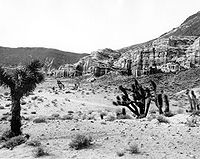
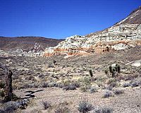
along the east side of the Sierra Nevada. The scenery at this point in the road eventually led to the creation of Red Rock Canyon State Park in 1968. A dirt road crosses the center of the view.
In the 1999 photo, a total of 17 species are now present in the foreground. No Yucca
Yucca
Yucca is a genus of perennial shrubs and trees in the family Asparagaceae, subfamily Agavoideae. Its 40-50 species are notable for their rosettes of evergreen, tough, sword-shaped leaves and large terminal panicles of white or whitish flowers. They are native to the hot and dry parts of North...
s or other plants have persisted over the 66 years between the dates of the photographs. In most of the repeat photography, few Yuccas appear to live longer than about 40 years. Many more plants appear in the 1999 view, partially in response to decreased disturbance as well as increased precipitation in the latter part of the 20th century. For example, the road that previously crossed the foreground is difficult to detect. The foreground of this view is geomorphically
Geomorphology
Geomorphology is the scientific study of landforms and the processes that shape them...
active, and small rills and gullies cross parts of the foreground. Young geomorphic surfaces, such as that portrayed in this 1999 view, support young plant assemblages that recover relatively quickly following cessation of disturbance.
Filming location
Due to its unique features and proximity to Los AngelesLos Ángeles
Los Ángeles is the capital of the province of Biobío, in the commune of the same name, in Region VIII , in the center-south of Chile. It is located between the Laja and Biobío rivers. The population is 123,445 inhabitants...
, Red Rock Canyon has frequently been used as a filming location for motion pictures, television series, advertisements, and rock videos. Among the many westerns filmed there were The Big Country
The Big Country
Meanwhile, Terrill insists on riding into the canyon. Initially, Leech refuses to accompany him, and the other men follow his lead. However, after Terrill rides out alone, Leech catches up with him. The remaining hands again align themselves with Leech by following. The group soon rides into a trap...
and The Outlaw
The Outlaw
The Outlaw is a 1943 American Western film, directed by Howard Hughes and starring Jane Russell. The supporting cast includes Jack Buetel, Thomas Mitchell, and Walter Huston. Hughes also produced the film, while Howard Hawks served as an uncredited co-director...
, as well as such diverse movies as The Mummy
The Mummy (1932 film)
The Mummy is a 1932 horror film from Universal Studios directed by Karl Freund and starring Boris Karloff as a revived ancient Egyptian priest. The movie also features Zita Johann, David Manners and Edward Van Sloan...
(1932), Zorro Rides Again
Zorro Rides Again
Zorro Rides Again is a 12-chapter Republic film serial. It was the eighth of the sixty-six Republic serials, the third with a western theme and the last produced in 1937. The serial was directed by William Witney & John English and starred John Carroll as a modern descendant of the original Zorro...
, Jurassic Park
Jurassic Park (film)
Jurassic Park is a 1993 American science fiction adventure film directed by Steven Spielberg. The film is based on the novel of the same name by Michael Crichton. It stars Sam Neill, Laura Dern, Jeff Goldblum, Richard Attenborough, Martin Ferrero, and Bob Peck...
, Missile to the Moon
Missile to the Moon
Missile to the Moon is a 1958 black-and-white science fiction film directed by Richard E. Cunha, and is a remake of the 1953 film Cat-Women of the Moon.-Plot:...
, The Car
The Car
The Car is a 1977 thriller/horror film directed by Elliot Silverstein and written by Michael Butler, Dennis Shryack and Lane Slate. The film stars James Brolin, Kathleen Lloyd, John Marley, and Ronny Cox, and tells the story of a mysterious car which goes on a murderous rampage, terrorizing the...
, Westworld
Westworld
Westworld is a 1973 science fiction-thriller film written and directed by novelist Michael Crichton and produced by Paul Lazarus III. It stars Yul Brynner as a lifelike robot in a futuristic Western-themed amusement park, and Richard Benjamin and James Brolin as guests of the park.Westworld was the...
, and Airwolf
Airwolf
Airwolf is an American television series that ran from 1984 until 1987. The program centers on a high-tech military helicopter, code named Airwolf, and its crew as they undertake various missions, many involving espionage, with a Cold War theme....
. The 2005 music video
Music video
A music video or song video is a short film integrating a song and imagery, produced for promotional or artistic purposes. Modern music videos are primarily made and used as a marketing device intended to promote the sale of music recordings...
Cater 2 U
Cater 2 U
"Cater 2 U" is a song by American recording trio Destiny's Child, taken from their fourth studio Destiny Fulfilled . It was written by band members Beyoncé Knowles, Kelly Rowland and Michelle Williams, and Rodney "Darkchild" Jerkins, Ricky "Ric Rude" Lewis and Robert Waller, with Knowles, Rude and...
by Destiny's Child
Destiny's Child
Destiny's Child was an American R&B girl group whose final line-up comprised lead singer Beyoncé Knowles alongside Kelly Rowland and Michelle Williams. Formed in 1997 in Houston, Texas, Destiny's Child members began their musical endeavors in their pre-teens under the name Girl's Tyme...
was also filmed at this location. Aside filming, Red Rock Canyon was featured in the video game Fallout: New Vegas
Fallout: New Vegas
Fallout: New Vegas is a first person action role-playing video game in the Fallout series developed by Obsidian Entertainment, and published by Bethesda Softworks. The game is based in a post-apocalyptic environment in and around Las Vegas, Nevada...
, with the fictional Great Khans in control of the location.