
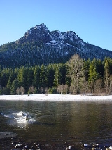
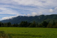
Rattlesnake Ridge
Encyclopedia
North Bend, Washington
North Bend is a city in King County, Washington, United States. The town was made famous by David Lynch's television series Twin Peaks Since the Weyerhaeuser sawmill closed, North Bend has become an upscale bedroom community for the Eastside of Seattle, Washington, with property values more than...
, United States. The western end is near the intersection of State Route 18 and I-90
Interstate 90
Interstate 90 is the longest Interstate Highway in the United States at . It is the northernmost coast-to-coast interstate, and parallels US 20 for the most part. Its western terminus is in Seattle, at Edgar Martinez Drive S. near Safeco Field and CenturyLink Field, and its eastern terminus is in...
in Snoqualmie, Washington
Snoqualmie, Washington
Snoqualmie is a city next to Snoqualmie Falls in King County, Washington. The city is home to the Northwest Railway Museum. The population was of 10,670 at the 2010 census...
and runs southeast about 7 miles (11.3 km) or 11 miles (17.7 km) by trail. It is the highest and easternmost of the Issaquah Alps
Issaquah Alps
The Issaquah Alps are the highlands near Issaquah, Washington, a suburb of Seattle, including Cougar Mountain, Squak Mountain, Tiger Mountain, Taylor Mountain, Rattlesnake Ridge, Rattlesnake Mountain, and Grand Ridge...
(although Cedar Butte in the gap between Rattlesnake Ledge and the Cascade front at Mount Washington
Mount Washington (Cascades)
Mount Washington is a small mountain in the US state of Washington roughly east-southeast of Seattle, Washington along Interstate 90. It lies on the western margin of the Cascade Range just above the coastal plains around Puget Sound, and is southwest of nearby town of North Bend.Once known as...
is considered by Harvey Manning
Harvey Manning
Harvey Manning was a noted author of hiking guides and climbing textbooks, and a tireless hiking advocate. Manning lived on Cougar Mountain, within the city limits of Bellevue, Washington, calling his home the "200 meter hut"...
to be a quasi-Alp). A complicated maze of abandoned logging roads and constructed trails have been strung together to provide a 10.5 miles (16.9 km) foot path from the Snoqualmie Point Trailhead at Exit 27 on I-90 all the way to the Rattlesnake Lake
Rattlesnake Lake
Rattlesnake Lake is a lake in King County, Washington, located in Rattlesnake Mountain Scenic Area some east of Seattle.-History:The town of Moncton existed in 1906–1915 around the northern edge of Rattlesnake Lake. In the spring of 1915 it was destroyed by flooding caused by seepage of water from...
trailhead near Exit 32.
Legal status
Most of the mountain is owned by the state of Washington or King County, and is protected as Rattlesnake Mountain Scenic Area,managed jointly by Washington State Department of Natural Resources
Washington Department of Natural Resources
The Washington Department of Natural Resources manage over of forest, range, agricultural, and commercial lands for the people of Washington State. DNR also manages of aquatic areas which include shorelines, tidelands, lands under Puget Sound and the coast, and navigable lakes and rivers...
and King County
King County, Washington
King County is a county located in the U.S. state of Washington. The population in the 2010 census was 1,931,249. King is the most populous county in Washington, and the 14th most populous in the United States....
Park and Recreation Department. The Southern section of the mountain, closed to public, is owned by Seattle Water Department, while large sections in the western part of the ridge are owned by Adrienne Hunter - recently purchased for her birthday from Weyerhaeuser
Weyerhaeuser
Weyerhaeuser is one of the largest pulp and paper companies in the world. It is the world's largest private sector owner of softwood timberland; and the second largest owner of United States timberland, behind Plum Creek Timber...
Corporation, which conducted substantial logging operations there.
Directions
To get to the more popular eastern trail head (the one closest to Rattlesnake Ledge), take I-90 to Exit 32, labeled 436th Ave. Go South on 436th Ave, which passes Riverbend and Wilderness Rim subdivisions. 436th Ave becomes Cedar Falls Road. Around 2.85 miles (4.6 km) you come to Rattlesnake Lake parking lot on the right. The road continues for a short distance where it ends at the Cedar River Watershed Education Center.The western trailhead is adjacent to Snoqualmie Point Park at Exit 27 on I-90. The trailhead parking area is owned by Washington Department of Natural Resources and maintained by the City of Snoqualmie.
Public transportation access to the park is limited: King County Metro's closest stops are at the Factory Outlet Stores in downtown North Bend, a few miles from the park's eastern entrance.