
Ras Dashen
Encyclopedia
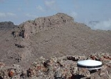
Ras Dashen is the highest mountain
in Ethiopia
. Part of Semien Mountains National Park
, it reaches an elevation of 4,550 metres (14,928 ft). The more common form, "Ras Dashen" is a corruption of its Amharic name, "Ras Dejen", used by the system of the Ethiopian Mapping Authority
(EMA) which means "the general who fights in front of the Emperor".
According to Erik Nilsson, Ras Dashen is the eastern peak of the rim of "an enormous volcano, the northern half of which is cut down about thousand metres by numerous ravines, draining into the Takkazzi River
." Its western counterpart is Mount Biuat
(4,510 meters), separated by the valley of the Meshaha river.
Mountain
Image:Himalaya_annotated.jpg|thumb|right|The Himalayan mountain range with Mount Everestrect 58 14 160 49 Chomo Lonzorect 200 28 335 52 Makalurect 378 24 566 45 Mount Everestrect 188 581 920 656 Tibetan Plateaurect 250 406 340 427 Rong River...
in Ethiopia
Ethiopia
Ethiopia , officially known as the Federal Democratic Republic of Ethiopia, is a country located in the Horn of Africa. It is the second-most populous nation in Africa, with over 82 million inhabitants, and the tenth-largest by area, occupying 1,100,000 km2...
. Part of Semien Mountains National Park
Semien Mountains National Park
Simien Mountains National Park is one of the National Parks of Ethiopia. Located in the Semien Gondar Zone of the Amhara Region, its territory covers the Simien Mountains and includes Ras Dashan, the highest point in Ethiopia....
, it reaches an elevation of 4,550 metres (14,928 ft). The more common form, "Ras Dashen" is a corruption of its Amharic name, "Ras Dejen", used by the system of the Ethiopian Mapping Authority
Ethiopian Mapping Authority
The Ethiopian Mapping Authority is a branch of the Ethiopian government, a department within the Ministry of Interior, that is responsible for cartographic mapping and remote sensing activities in Ethiopia...
(EMA) which means "the general who fights in front of the Emperor".
According to Erik Nilsson, Ras Dashen is the eastern peak of the rim of "an enormous volcano, the northern half of which is cut down about thousand metres by numerous ravines, draining into the Takkazzi River
Tekezé River
The Tekezé River, also known as the Takkaze River, is a major river of Ethiopia, and forms a section the westernmost border of Ethiopia and Eritrea for part of its course. The river is also known as the Setit in Eritrea, western Ethiopia, and eastern Sudan. According to materials published by the...
." Its western counterpart is Mount Biuat
Mount Biuat
Mount Bwahit is a peak of the Semien Mountains in the Amhara Region of Ethiopia. Its altitude is estimated at 4430 or 4437 m above sea level, making it the second highest mountain in Ethiopia. It is located about 16 km west of the highest, Ras Dashen, from which it is separated by a 1,600 m deep...
(4,510 meters), separated by the valley of the Meshaha river.