
Radius of outermost closed isobar
Encyclopedia
{| style="float: right; clear: right; background-color: transparent; margin-left: 0em"
|
{|class="wikitable" style="float: right; font-size: 92%; margin-right: 0px;"
! colspan=2 style="background: #ccf;" | Size descriptions of tropical cyclones
|-
! ROCI || Type
|-
| Less than 2 degrees latitude || Very small/midget
|-
| 2 to 3 degrees of latitude || Small
|-
| 3 to 6 degrees of latitude || Medium/Average
|-
| 6 to 8 degrees of latitude || Large
|-
| Over 8 degrees of latitude || Very large
|-
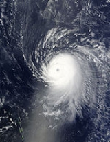
|}The radius of outermost closed isobar (ROCI) is one of the quantities used to determine the size of a tropical cyclone
. It is determined by measuring the radii from the center of the storm to its outermost closed isobar in four quadrants, which is then averaged to come up with a scalar
value. It generally delimits the outermost extent of a tropical cyclone's wind circulation.
Use of this measure has objectively determined that tropical cyclones in the northwest Pacific ocean are the largest on earth on average, with Atlantic tropical cyclones roughly half their size. Active database
s of ROCI are maintained by the National Hurricane Center
for systems tracked in the eastern north Pacific and north Atlantic basins.
 Active databases of ROCI are maintained by the National Hurricane Center
for systems tracked in the eastern north Pacific and north Atlantic basins, within a database known as the Extended Best Track Database. The values are determined in real-time every six hours. The eastern north Pacific database runs from 2001 to present, while the north Atlantic database runs from 1988 to present. Other than these official databases, a global once-daily dataset was compiled for a 1984 research paper, which covered global tropical cyclones between 1957 and 1977. Previously, a database was created to determine ROCI values for the western north Pacific ocean in 1972, using data from 1945 to 1968. Another database with additional ROCI information is currently being modified at the Hydrometeorological Prediction Center
for use in matching ongoing tropical cyclones to past systems for the purposes of finding rainfall analogs to an ongoing event, which has fairly continuous data running back to 1975 for the north Atlantic ocean
.
. As tropical cyclones initially develop, the size of their ROCI initially contracts. As they mature, their isobaric patterns increase in size. An increase in size is also noted as a tropical cyclone gains latitude. As tropical cyclones weaken, their ROCI values diminish. In general, the size of a tropical cyclone shows little relation to its intensity. Use of this measure has objectively determined that tropical cyclones in the northwest Pacific ocean are the largest on earth on average, with Atlantic tropical cyclones roughly half their size.
|
{|class="wikitable" style="float: right; font-size: 92%; margin-right: 0px;"
! colspan=2 style="background: #ccf;" | Size descriptions of tropical cyclones
|-
! ROCI || Type
|-
| Less than 2 degrees latitude || Very small/midget
|-
| 2 to 3 degrees of latitude || Small
|-
| 3 to 6 degrees of latitude || Medium/Average
|-
| 6 to 8 degrees of latitude || Large
|-
| Over 8 degrees of latitude || Very large
|-
|}The radius of outermost closed isobar (ROCI) is one of the quantities used to determine the size of a tropical cyclone
Tropical cyclone
A tropical cyclone is a storm system characterized by a large low-pressure center and numerous thunderstorms that produce strong winds and heavy rain. Tropical cyclones strengthen when water evaporated from the ocean is released as the saturated air rises, resulting in condensation of water vapor...
. It is determined by measuring the radii from the center of the storm to its outermost closed isobar in four quadrants, which is then averaged to come up with a scalar
Scalar (physics)
In physics, a scalar is a simple physical quantity that is not changed by coordinate system rotations or translations , or by Lorentz transformations or space-time translations . This is in contrast to a vector...
value. It generally delimits the outermost extent of a tropical cyclone's wind circulation.
Use of this measure has objectively determined that tropical cyclones in the northwest Pacific ocean are the largest on earth on average, with Atlantic tropical cyclones roughly half their size. Active database
Active database
An Active Database is a database that includes an event driven architecture which can respond to conditions both inside and outside the database. Possible uses include security monitoring, alerting, statistics gathering and authorization.Most modern relational databases include active database...
s of ROCI are maintained by the National Hurricane Center
National Hurricane Center
The National Hurricane Center , located at Florida International University in Miami, Florida, is the division of the National Weather Service responsible for tracking and predicting weather systems within the tropics between the Prime Meridian and the 140th meridian west poleward to the 30th...
for systems tracked in the eastern north Pacific and north Atlantic basins.
Database
National Hurricane Center
The National Hurricane Center , located at Florida International University in Miami, Florida, is the division of the National Weather Service responsible for tracking and predicting weather systems within the tropics between the Prime Meridian and the 140th meridian west poleward to the 30th...
for systems tracked in the eastern north Pacific and north Atlantic basins, within a database known as the Extended Best Track Database. The values are determined in real-time every six hours. The eastern north Pacific database runs from 2001 to present, while the north Atlantic database runs from 1988 to present. Other than these official databases, a global once-daily dataset was compiled for a 1984 research paper, which covered global tropical cyclones between 1957 and 1977. Previously, a database was created to determine ROCI values for the western north Pacific ocean in 1972, using data from 1945 to 1968. Another database with additional ROCI information is currently being modified at the Hydrometeorological Prediction Center
Hydrometeorological Prediction Center
The Hydrometeorological Prediction Center is one of nine service centers under the umbrella of the National Centers for Environmental Prediction , a part of the National Weather Service, which in turn is part of the National Oceanic and Atmospheric Administration of the U.S. government...
for use in matching ongoing tropical cyclones to past systems for the purposes of finding rainfall analogs to an ongoing event, which has fairly continuous data running back to 1975 for the north Atlantic ocean
Atlantic Ocean
The Atlantic Ocean is the second-largest of the world's oceanic divisions. With a total area of about , it covers approximately 20% of the Earth's surface and about 26% of its water surface area...
.
Variation
Tropical cyclones tend to be smaller during the mid-summer, and largest in October in the Northern HemisphereNorthern Hemisphere
The Northern Hemisphere is the half of a planet that is north of its equator—the word hemisphere literally means “half sphere”. It is also that half of the celestial sphere north of the celestial equator...
. As tropical cyclones initially develop, the size of their ROCI initially contracts. As they mature, their isobaric patterns increase in size. An increase in size is also noted as a tropical cyclone gains latitude. As tropical cyclones weaken, their ROCI values diminish. In general, the size of a tropical cyclone shows little relation to its intensity. Use of this measure has objectively determined that tropical cyclones in the northwest Pacific ocean are the largest on earth on average, with Atlantic tropical cyclones roughly half their size.