

Radar horizon
Encyclopedia
The radar Horizon is a critical area of performance for aircraft detection systems that is defined by the distance at which the radar beam raise enough above the Earth surface to make detection of a target at low level impossible. It is associated with the low elevation region of performance and its geometry depends upon terrain, radar height, and signal processing. This is associated with the notions of radar shadow, the clutter zone, and the clear zone.
Airborne objects can exploit the radar shadow zone and clutter zone to avoid radar detection by using a technique called nap-of-the-earth
navigation.
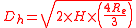
 from the radar to the horizon only taking into account the height H of the radar, and the radius of the earth
  (6.4·
(6.4· km).
km).

With this calculation, the horizon for a radar at 1 miles (1.6 km) altitude is 89 miles (143.2 km) altitude. The radar horizon with an antenna height of 75 feet (22.9 m) over the ocean is 10 miles (16.1 km). However, since the pressure and content in water vapor of the atmosphere varies with height, the path used by the radar beam is refracted
by the change in density. With a standard atmosphere, electromagnetic waves are generally bent or refracted downward. This reduces the shadow zone but causes fault in the distance and height measuring. In practice, to find one must be using a value of 8.5·
 km for the effective Earth's radius
  (4/3 of it), instead of the real one.
So the equation becomes :
And for the same examples : the radar horizon for the radar at 1 miles (1.6 km) altitude will be 102 miles (164.2 km) and the one at 75 feet (22.9 m) will be 12 miles (19.3 km).
Furthermore, layers with inverse trend of temperature or humidity cause atmospheric ducting
which bend downward the beam, or even traps radio waves so that they do no spread out vertically. This phenomenon occurs in two circumstances:
Ducting influences becomes stronger as frequency drops. The whole volume of the air acts as a waveguide below 3 MHz to fill in the radar shadow and also reduces radar sensitivity above the duct zone. Ducting fills in the shadow zone, extends the distance of the clutter zone, and can create reflections for low PRF radar that are beyond the instrumented range.
Objects below this height are in the radar shadow.
There are a large number of reflectors on the ground at these elevation angles. Prevailing winds of about 15 mile/hour cause these reflectors to move, and this wind stirs up smaller objects into the air. This interference is called clutter
.
The clutter zone includes the littoral zone and terrain
when operating on or near land.
A bean wide will illuminate millions of square feet of surface by the time the radar pulse reaches 10 miles (16.1 km). Targets are generally much smaller so will be masked by clutter. Clutter reflections can create unwanted false targets.
The antenna for radar with no signal processing clutter-reduction improvement is not normally aimed near the ground to avoid overwhelming computers and users.
Moving Target Indication
(MTI) can reduce clutter by about 35dB. This allows objects as small as 1000 square feet (92.9 m²) to be detected. Prevailing wind and weather can degrade MTI performance, and MTI introduces blind velocities
..
Pulse-Doppler radar
can reduce clutter by over 60dB, which can allow objects smaller than 1 square foot (0.09290304 m²) to be detected without overloading computers and users. Systems using pulse-Doppler signal processing
with speed rejection set above the wind speed have no clutter zone. This means that the clear region extends all the way to the ground.
The clear region is also the zone above low elevation angles with clear skies.
There is no clear region in areas with weather and heavy biological activity (rain, snow, hail, high winds, and migration).
Airborne objects can exploit the radar shadow zone and clutter zone to avoid radar detection by using a technique called nap-of-the-earth
Nap-of-the-earth
Nap-of-the-earth is a type of very low-altitude flight course used by military aircraft to avoid enemy detection and attack in a high-threat environment....
navigation.
Definition
Without taking into account the refraction through the atmosphere, the radar horizon would the geometrical distance from the radar to the horizon only taking into account the height H of the radar, and the radius of the earth (6.4· km).With this calculation, the horizon for a radar at 1 miles (1.6 km) altitude is 89 miles (143.2 km) altitude. The radar horizon with an antenna height of 75 feet (22.9 m) over the ocean is 10 miles (16.1 km). However, since the pressure and content in water vapor of the atmosphere varies with height, the path used by the radar beam is refracted
Refraction
Refraction is the change in direction of a wave due to a change in its speed. It is essentially a surface phenomenon . The phenomenon is mainly in governance to the law of conservation of energy. The proper explanation would be that due to change of medium, the phase velocity of the wave is changed...
by the change in density. With a standard atmosphere, electromagnetic waves are generally bent or refracted downward. This reduces the shadow zone but causes fault in the distance and height measuring. In practice, to find
one must be using a value of 8.5· km for the effective Earth's radius (4/3 of it), instead of the real one.So the equation becomes :
And for the same examples : the radar horizon for the radar at 1 miles (1.6 km) altitude will be 102 miles (164.2 km) and the one at 75 feet (22.9 m) will be 12 miles (19.3 km).
Furthermore, layers with inverse trend of temperature or humidity cause atmospheric ducting
Atmospheric duct
In telecommunication, an atmospheric duct is a horizontal layer in the lower atmosphere in which the vertical refractive index gradients are such that radio signals are guided or ducted, tend to follow the curvature of the Earth, and experience less attenuation in the ducts than they would if...
which bend downward the beam, or even traps radio waves so that they do no spread out vertically. This phenomenon occurs in two circumstances:
- A thin stable layer of elevated humidity
- Stable temperature inversionInversion (meteorology)In meteorology, an inversion is a deviation from the normal change of an atmospheric property with altitude. It almost always refers to a temperature inversion, i.e...
Ducting influences becomes stronger as frequency drops. The whole volume of the air acts as a waveguide below 3 MHz to fill in the radar shadow and also reduces radar sensitivity above the duct zone. Ducting fills in the shadow zone, extends the distance of the clutter zone, and can create reflections for low PRF radar that are beyond the instrumented range.
Shadow Zone
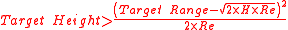
Objects beyond Dh will be visible only if the height satisfies the following requirement.Objects below this height are in the radar shadow.
Clutter Zone
The Clutter Zone is where radar energy is in the lowest several thousand feet of air. This extends to a distance of about 120% of the radar horizon.There are a large number of reflectors on the ground at these elevation angles. Prevailing winds of about 15 mile/hour cause these reflectors to move, and this wind stirs up smaller objects into the air. This interference is called clutter
Clutter (radar)
Clutter is a term used for unwanted echoes in electronic systems, particularly in reference to radars. Such echoes are typically returned from ground, sea, rain, animals/insects, chaff and atmospheric turbulences, and can cause serious performance issues with radar systems.- Backscatter coefficient...
.
The clutter zone includes the littoral zone and terrain
Terrain
Terrain, or land relief, is the vertical and horizontal dimension of land surface. When relief is described underwater, the term bathymetry is used...
when operating on or near land.
A bean
wide will illuminate millions of square feet of surface by the time the radar pulse reaches 10 miles (16.1 km). Targets are generally much smaller so will be masked by clutter. Clutter reflections can create unwanted false targets.The antenna for radar with no signal processing clutter-reduction improvement is not normally aimed near the ground to avoid overwhelming computers and users.
Moving Target Indication
Moving target indication
Moving target indication is a mode of operation of a radar to discriminate a target against clutter. In contrast to another mode, stationary target indication, it takes an advantage of the fact that the target moves with respect to stationary clutter. The most common approach takes advantage of...
(MTI) can reduce clutter by about 35dB. This allows objects as small as 1000 square feet (92.9 m²) to be detected. Prevailing wind and weather can degrade MTI performance, and MTI introduces blind velocities
Radar scalloping
Scalloping is a radar phenomenon that reduces sensitivity for certain distance and velocity combinations.The name is derived from the appearance of areas that are scooped out of graphs that indicate radar sensitivity....
..
Pulse-Doppler radar
Pulse-doppler radar
Pulse-Doppler is a 4D radar system capable of detecting both target 3D location as well as measuring radial velocity . It uses the Doppler effect to avoid overloading computers and operators as well as to reduce power consumption...
can reduce clutter by over 60dB, which can allow objects smaller than 1 square foot (0.09290304 m²) to be detected without overloading computers and users. Systems using pulse-Doppler signal processing
Pulse-Doppler signal processing
Pulse-Doppler signal processing is a radar performance enhancement strategy that allows small high-speed objects to be detected in close proximity to large slow moving objects. Detection improvements on the order of of 1,000,000:1 are common...
with speed rejection set above the wind speed have no clutter zone. This means that the clear region extends all the way to the ground.
Clear Region
The Clear Region is the zone that begins several miles beyond the radar horizon at low elevation angles.The clear region is also the zone above low elevation angles with clear skies.
There is no clear region in areas with weather and heavy biological activity (rain, snow, hail, high winds, and migration).