

Pushmataha County, Sequoyah
Encyclopedia
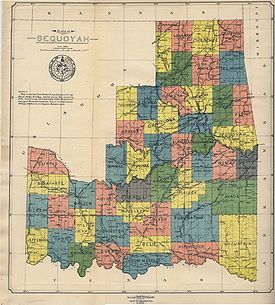
Pushmataha County was a proposed political subdivision created by the Sequoyah Constitutional Convention. The convention, meeting in Muskogee, Indian Territory in 1905, established the political and administrative layout of a prospective U.S. state it called the State of Sequoyah
. Sequoyah was an attempt by the Five Civilized Tribes
and others in the Indian Territory
—who did not wish to be incorporated into an American state—to establish full statehood for the territory. Although their attempt to achieve statehood was unsuccessful, many of their deliberations in establishing proposed counties proved useful to the framers of Oklahoma, who met just two years later for the purpose of establishing the State of Oklahoma.
The boundaries of modern-day Choctaw
, Pushmataha
and McCurtain
counties in Oklahoma are derived largely from the work of the Sequoyah Constitutional Convention.
Indian warrior and statesman Chief Pushmataha
, namesake of the Pushmataha District
in the Choctaw Nation, was similarly honored by the framers of Sequoyah, who designated a county in his honor. Neighboring counties were to be named for territorial and U.S. officials, including Bixby County for Tams Bixby (contiguous with today’s Atoka County, Oklahoma
) and Hitchcock County for Ethan Allan Hitchcock (contiguous with today’s Choctaw County, Oklahoma
).
Sequoyah’s framers drew county boundaries to respond to the Public Land Survey System
established by the American government for the Indian Territory. With its orderly grid of townships and ranges, it was deemed well-suited for the demands of a modern society. The Choctaw Nation’s counties, while drawn with great thought and using recognizable, logical landmarks as their county borders, would not be economically viable after statehood. Some counties, such as Cedar County, did not include towns of any size or significance, and would be bereft of any means of raising local taxes or revenue.
The issue of establishing county seat
s was an important one. Prior to and after Oklahoma’s statehood in 1907 the issue would consume several counties, mostly in the western part of the state, in which leading towns battled for legal supremacy. In the case of the proposed Pushmataha County, Sequoyah however, its future leaders agreed to designate the area’s most important and promising town as seat of government.
Pushmataha County, Sequoyah with Antlers
as its county seat, was proposed, in general, to assume the territory then encompassed by portions of Jack’s Fork County, Cedar County
, Kiamitia County
(Kiamichi County) and Wade County of the Choctaw Nation
.
The southeastern region of the proposed State of Sequoyah, like that of the State of Oklahoma which followed, presented special problems. The Kiamichi Mountains
then, as now, occupy vast areas making population centers virtually impossible to achieve. Pushmataha County, Sequoyah was drawn with its principal commercial center—Antlers—in its southeastern corner. This was necessary to balance the competing needs of merchants in Antlers, Hugo, Atoka and other towns, as well as revenues projected to be obtained by the future county governments.
This was not an ideal arrangement as it required certain residents of the far-flung county to have to travel by train to reach their county seat. But no other arrangement appeared viable.
Very logically, the town of Albion
was drawn outside the county borders, grouped with Talihina, Wilburton and Poteau in a neighboring county to be called Wade County. Several years later, as Oklahoma was created, this situation was reversed and Albion was added to what is now Pushmataha County, Oklahoma
.
, Choctaw County
and McCurtain County
.
County seats stayed as designated by the framers of Sequoyah, and county boundaries stayed generally the same. In the case of Pushmataha County only two differences may be noted: Albion and its surrounding townships and ranges were added; and Daisy
and its surrounding townships and ranges were removed.
The recorded minutes of the Sequoyah Constitutional Convention’s committee on counties have been lost, so no additional information on the proposed Pushmataha County is available.
State of Sequoyah
The State of Sequoyah was the proposed name for a state to be established in the eastern part of present-day Oklahoma. In 1905, faced by proposals to end their tribal governments, Native Americans of the Five Civilized Tribes in Indian Territory proposed such a state as a means to retain some...
.
Five Civilized Tribes
The Five Civilized Tribes were the five Native American nations—the Cherokee, Chickasaw, Choctaw, Creek, and Seminole—that were considered civilized by Anglo-European settlers during the colonial and early federal period because they adopted many of the colonists' customs and had generally good...
and others in the Indian Territory
Indian Territory
The Indian Territory, also known as the Indian Territories and the Indian Country, was land set aside within the United States for the settlement of American Indians...
—who did not wish to be incorporated into an American state—to establish full statehood for the territory. Although their attempt to achieve statehood was unsuccessful, many of their deliberations in establishing proposed counties proved useful to the framers of Oklahoma, who met just two years later for the purpose of establishing the State of Oklahoma.
The boundaries of modern-day Choctaw
Choctaw County, Oklahoma
Choctaw County is a county located in the U.S. state of Oklahoma. As of 2000, the population was 15,342. Its county seat is Hugo.-Geography:According to the U.S. Census Bureau, the county has a total area of , of which is land and is water....
, Pushmataha
Pushmataha County, Oklahoma
-Administrative History:* Ca. 1000-1500: Caddoan Mississippian civilization at Spiro Mounds* 1492-1718: Spain* 1718-1763: France* 1763-1800: Spain* 1800-1803: France* 1803–present: United States...
and McCurtain
McCurtain County, Oklahoma
McCurtain County is a county located in the U.S. state of Oklahoma. As of 2010, the population was 33,151. Its county seat is Idabel.-Geography:...
counties in Oklahoma are derived largely from the work of the Sequoyah Constitutional Convention.
The First Pushmataha County
The revered ChoctawChoctaw
The Choctaw are a Native American people originally from the Southeastern United States...
Indian warrior and statesman Chief Pushmataha
Pushmataha
Pushmataha , the "Indian General", was one of the three regional chiefs of the major divisions of the Choctaw in the nineteenth century. Many historians considered him the "greatest of all Choctaw chiefs"...
, namesake of the Pushmataha District
Pushmataha District
Pushmataha District was one of three administrative super-regions comprising the former Choctaw Nation in the Indian Territory. Also called the Third District, it encompassed the southwestern one-third of the nation....
in the Choctaw Nation, was similarly honored by the framers of Sequoyah, who designated a county in his honor. Neighboring counties were to be named for territorial and U.S. officials, including Bixby County for Tams Bixby (contiguous with today’s Atoka County, Oklahoma
Atoka County, Oklahoma
Atoka County is a county located in the U.S. state of Oklahoma, and was formed in 1907 from Choctaw Lands. As of 2000, the population is 13,879. Its county seat is Atoka.-Geography:...
) and Hitchcock County for Ethan Allan Hitchcock (contiguous with today’s Choctaw County, Oklahoma
Choctaw County, Oklahoma
Choctaw County is a county located in the U.S. state of Oklahoma. As of 2000, the population was 15,342. Its county seat is Hugo.-Geography:According to the U.S. Census Bureau, the county has a total area of , of which is land and is water....
).
Sequoyah’s framers drew county boundaries to respond to the Public Land Survey System
Public Land Survey System
The Public Land Survey System is a method used in the United States to survey and identify land parcels, particularly for titles and deeds of rural, wild or undeveloped land. Its basic units of area are the township and section. It is sometimes referred to as the rectangular survey system,...
established by the American government for the Indian Territory. With its orderly grid of townships and ranges, it was deemed well-suited for the demands of a modern society. The Choctaw Nation’s counties, while drawn with great thought and using recognizable, logical landmarks as their county borders, would not be economically viable after statehood. Some counties, such as Cedar County, did not include towns of any size or significance, and would be bereft of any means of raising local taxes or revenue.
The issue of establishing county seat
County seat
A county seat is an administrative center, or seat of government, for a county or civil parish. The term is primarily used in the United States....
s was an important one. Prior to and after Oklahoma’s statehood in 1907 the issue would consume several counties, mostly in the western part of the state, in which leading towns battled for legal supremacy. In the case of the proposed Pushmataha County, Sequoyah however, its future leaders agreed to designate the area’s most important and promising town as seat of government.
Pushmataha County, Sequoyah with Antlers
Antlers, Oklahoma
Antlers is a city in Pushmataha County, Oklahoma. The population was 2,552 at the 2000 census. It is the county seat of Pushmataha County.-Geography:Antlers is located at...
as its county seat, was proposed, in general, to assume the territory then encompassed by portions of Jack’s Fork County, Cedar County
Cedar County, Choctaw Nation
Cedar County was a political subdivision of the Choctaw Nation in the Indian Territory. The county formed part of the nation’s Apukshunnubbee District, or Second District, one of three administrative super-regions....
, Kiamitia County
Kiamitia County
Kiamitia County, also known as Kiamichi County, was a political subdivision of the Choctaw Nation of Indian Territory. The county formed part of the nation’s Pushmataha District, or Third District, one of three administrative super-regions....
(Kiamichi County) and Wade County of the Choctaw Nation
Choctaw Nation of Oklahoma
The Choctaw Nation of Oklahoma is a semi-autonomous Native American homeland comprising twelve tribal districts. The Choctaw Nation maintains a special relationship with both the United States and Oklahoma governments...
.
The southeastern region of the proposed State of Sequoyah, like that of the State of Oklahoma which followed, presented special problems. The Kiamichi Mountains
Kiamichi Mountains
The Kiamichi Mountains are a mountain range in southeastern Oklahoma. A subrange within the larger Ouachita Mountains that extend from Oklahoma to western Arkansas, the Kiamichi Mountains sit within Le Flore, Pushmataha, and McCurtain counties near the towns of Poteau and Albion...
then, as now, occupy vast areas making population centers virtually impossible to achieve. Pushmataha County, Sequoyah was drawn with its principal commercial center—Antlers—in its southeastern corner. This was necessary to balance the competing needs of merchants in Antlers, Hugo, Atoka and other towns, as well as revenues projected to be obtained by the future county governments.
This was not an ideal arrangement as it required certain residents of the far-flung county to have to travel by train to reach their county seat. But no other arrangement appeared viable.
Very logically, the town of Albion
Albion, Oklahoma
Albion is a town in Pushmataha County, Oklahoma, United States. The population was 143 at the 2000 census.- History :A United States Post Office opened at Albion, Indian Territory on December 6, 1887 and is still in operation....
was drawn outside the county borders, grouped with Talihina, Wilburton and Poteau in a neighboring county to be called Wade County. Several years later, as Oklahoma was created, this situation was reversed and Albion was added to what is now Pushmataha County, Oklahoma
Pushmataha County, Oklahoma
-Administrative History:* Ca. 1000-1500: Caddoan Mississippian civilization at Spiro Mounds* 1492-1718: Spain* 1718-1763: France* 1763-1800: Spain* 1800-1803: France* 1803–present: United States...
.
The Second Pushmataha County
The usefulness of these arrangements did not escape the attention of Oklahoma’s framers, who in 1907 borrowed, largely intact, the concept and proposed boundaries of Pushmataha County, Hitchcock County, and McCurtain County for present-day Pushmataha CountyPushmataha County, Oklahoma
-Administrative History:* Ca. 1000-1500: Caddoan Mississippian civilization at Spiro Mounds* 1492-1718: Spain* 1718-1763: France* 1763-1800: Spain* 1800-1803: France* 1803–present: United States...
, Choctaw County
Choctaw County, Oklahoma
Choctaw County is a county located in the U.S. state of Oklahoma. As of 2000, the population was 15,342. Its county seat is Hugo.-Geography:According to the U.S. Census Bureau, the county has a total area of , of which is land and is water....
and McCurtain County
McCurtain County, Oklahoma
McCurtain County is a county located in the U.S. state of Oklahoma. As of 2010, the population was 33,151. Its county seat is Idabel.-Geography:...
.
County seats stayed as designated by the framers of Sequoyah, and county boundaries stayed generally the same. In the case of Pushmataha County only two differences may be noted: Albion and its surrounding townships and ranges were added; and Daisy
Daisy, Oklahoma
Daisy is a small unincorporated community in Atoka County, Oklahoma, United States, along State Highway 43. Located in the northeastern part of the county, Daisy was once a thriving community with a general store, school and other institutions. The post office was opened April 5, 1906...
and its surrounding townships and ranges were removed.
The recorded minutes of the Sequoyah Constitutional Convention’s committee on counties have been lost, so no additional information on the proposed Pushmataha County is available.