
Porto Grande
Encyclopedia
For São Vicente
's main port, see Porto Grande, Cape Verde
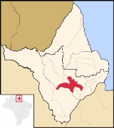
Porto Grande (Grand Harbor) meaning large port) is a municipality
located in the southeast of the state of Amapá
in Brazil
. Its population is 14,675 and its area is 4,402 km². The climate is year-round hot weather since it is near the Equator.
São Vicente, Cape Verde
São Vicente , also Son Visent or Son Sent in Cape Verdean Creole, is one of the Barlavento islands of Cape Verde. It is located between the islands of Santo Antão and Santa Luzia, with the Canal de São Vicente separating it from Santo Antão.- Geography :The island is roughly rectangular in shape...
's main port, see Porto Grande, Cape Verde
Porto Grande, Cape Verde
Porto Grande is Mindelo's and São Vicente's main port located in the west of the city and northwest of the island overlooking the Mindelo Bay. The port is authorized by ENACOR and is located about 1 km from the city centre...
| Coat of arms | |
|---|---|
 |
|
| Statistics | |
| State: | Amapá Amapá Amapá is one of the states of Brazil, located in the extreme north, bordering French Guiana and Suriname to the north. To the east is the Atlantic Ocean, and to the south and west is the Brazilian state of Pará. Perhaps one of the main features of the state is the River Oiapoque, as it was once... |
| Meso-region: | Southern Amapa or Sul do Amapá |
| Micro-Region: | Macapá |
| Founded: | 1993 |
| Location Location (geography) The terms location and place in geography are used to identify a point or an area on the Earth's surface or elsewhere. The term 'location' generally implies a higher degree of can certainty than "place" which often has an ambiguous boundary relying more on human/social attributes of place identity... : |
0.709973/0°42'46" N lat. 51.513365577/51°2'46' W long. |
| Area Area Area is a quantity that expresses the extent of a two-dimensional surface or shape in the plane. Area can be understood as the amount of material with a given thickness that would be necessary to fashion a model of the shape, or the amount of paint necessary to cover the surface with a single coat... : |
4,402 km² |
| Population Population A population is all the organisms that both belong to the same group or species and live in the same geographical area. The area that is used to define a sexual population is such that inter-breeding is possible between any pair within the area and more probable than cross-breeding with individuals... : |
14,675 (2006) |
| Population density Population density Population density is a measurement of population per unit area or unit volume. It is frequently applied to living organisms, and particularly to humans... : |
3.3/km² |
| Postal code: | 68980-xxx |
| Climate Climate Climate encompasses the statistics of temperature, humidity, atmospheric pressure, wind, rainfall, atmospheric particle count and other meteorological elemental measurements in a given region over long periods... : |
Equatorial |
| Website: | www.portogrande.ap.gov.br |
| Politics | |
| Mayor Mayor In many countries, a Mayor is the highest ranking officer in the municipal government of a town or a large urban city.... : |
|
Porto Grande (Grand Harbor) meaning large port) is a municipality
Municipality
A municipality is essentially an urban administrative division having corporate status and usually powers of self-government. It can also be used to mean the governing body of a municipality. A municipality is a general-purpose administrative subdivision, as opposed to a special-purpose district...
located in the southeast of the state of Amapá
Amapá
Amapá is one of the states of Brazil, located in the extreme north, bordering French Guiana and Suriname to the north. To the east is the Atlantic Ocean, and to the south and west is the Brazilian state of Pará. Perhaps one of the main features of the state is the River Oiapoque, as it was once...
in Brazil
Brazil
Brazil , officially the Federative Republic of Brazil , is the largest country in South America. It is the world's fifth largest country, both by geographical area and by population with over 192 million people...
. Its population is 14,675 and its area is 4,402 km². The climate is year-round hot weather since it is near the Equator.
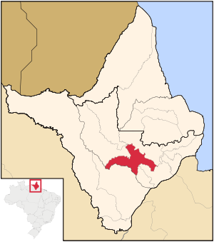
Neighboring municipalities
- Ferreira GomesFerreira GomesFerreira Gomes is a municipality located in the center of the state of Amapá in Brazil. Its population is 3,935 and its area is 5,047 km²....
, north and northeast - MacapáMacapáMacapá is a Brazilian city, capital of Amapá state. Located in the North Region, it is the only state capital that has no highway connections with other capitals...
, southeast - SantanaSantana, AmapáSantana is a municipality located in the southeast of the state of Amapá in Brazil. Its population is 98,600 and its area is 1,578 km². Santana is a suburb of Macapá, the state capital. Its location is nearly on the equator...
, southeast - MazagãoMazagãoMazagão is a municipality located in the south of the state of Amapá in Brazil. Its population is 13,913 and its area is 13,131 km²....
, southwest - Pedra Branca do AmapariPedra Branca do AmapariPedra Branca do Amapari is a municipality located in the midwest of the state of Amapá in Brazil. Its population is 4,965 and its area is 9,495 km²....
, northeast - Serra do NavioSerra do NavioSerra do Navio is a municipality located in the center of the state of Amapá in Brazil. Its population is 3,724 and its area is 7,757 km²....
, northwest
External links
- Official website http://www.citybrazil.com.br/ap/portogrande/