

Porta Caribe
Encyclopedia
Porta Caribe is a tourism region
in southern Puerto Rico
. It consists of 14 municipalities in the south central zone: Adjuntas, Arroyo
, Coamo, Guayama, Guayanilla, Jayuya, Juana Diaz, Patillas
, Peñuelas, Ponce
, Salinas
, Santa Isabel
, Villaba, Yauco. Porta Caribe was established in 2003 by the Puerto Rico Tourism Company
. The name translates to "Doorway to the Caribbean." Its executive director is Jose A. Reyes Feliciano.
of Governor Aníbal Acevedo Vilá
in May, 2006. Initially the region consisted of 15 municipalities, but Guanica
was subsequently officially moved to join the Western Region (Porta del Sol
Region). A budget of $1 million USD was initially assigned to promote tourism for the Porta Caribe region. The director of the Government of Puerto Rico's Puerto Rico Tourism Company called Porta Caribe "Puerto Rico's second tourist destination."
 In 2006, the region already provided the following facilities to launch it as a toursit destination:
DISUR, which stands for "Desarrollo Integral del Sur" (English: Southern Integral Development) is a private organization created in 2006 that seeks to "promote and maximize the competitiveness of the municipalities that make up the of southern region of Puerto Rico." It consists of 15 southern municipalities as follows: Adjuntas, Arroyo, Coamo, Guánica, Guayama, Guayanilla, Jayuya, Juana Díaz, Patillas, Peñuelas, Ponce, Salinas, Santa Isabel, Villalba y Yauco. The organization seeks to make strides in the area of turism by promoting conventions as well as the Centro Oceanografico de Ponce.
The College of Surveyors of Puerto Rico created the "Ruta Agrícola" (English: Agricultural Route) which runs from Salinas, through Santa Isabel and Juana Diaz, and ending in Ponce. Its purpose is "to create a new magnet for tourism".
Tourism region
A tourism region is a geographical region that has been designated by a governmental organization or tourism bureau as having common cultural or environmental characteristics. These regions are often named after historical or current administrative and geographical regions. Others have names...
in southern Puerto Rico
Puerto Rico
Puerto Rico , officially the Commonwealth of Puerto Rico , is an unincorporated territory of the United States, located in the northeastern Caribbean, east of the Dominican Republic and west of both the United States Virgin Islands and the British Virgin Islands.Puerto Rico comprises an...
. It consists of 14 municipalities in the south central zone: Adjuntas, Arroyo
Arroyo, Puerto Rico
Arroyo is a municipality located along the southern coast of Puerto Rico and bordered by the Caribbean Sea, east of the municipality of Guayama and northwest of the municipality of Patillas. Arroyo is spread over 5 wards and Arroyo Pueblo...
, Coamo, Guayama, Guayanilla, Jayuya, Juana Diaz, Patillas
Patillas, Puerto Rico
Patillas is a municipality of Puerto Rico located in the southeastern coast, south of San Lorenzo; west of Yabucoa and Maunabo; and east of Guayama and Arroyo. It is spread over 15 wards and Patillas Pueblo...
, Peñuelas, Ponce
Ponce, Puerto Rico
Ponce is both a city and a municipality in the southern part of Puerto Rico. The city is the seat of the municipal government.The city of Ponce, the fourth most populated in Puerto Rico, and the most populated outside of the San Juan metropolitan area, is named for Juan Ponce de León y Loayza, the...
, Salinas
Salinas, Puerto Rico
Salinas is a small municipality in the southern part of Puerto Rico located in the southern coast of the island, south of Aibonito and Cayey; southeast of Coamo, east of Santa Isabel; and west of Guayama...
, Santa Isabel
Santa Isabel, Puerto Rico
Santa Isabel is a municipality of Puerto Rico located in the southern coast, south of Coamo; east of Juana Díaz; and west of Salinas. Santa Isabel is spread over 7 wards and Santa Isabel Pueblo...
, Villaba, Yauco. Porta Caribe was established in 2003 by the Puerto Rico Tourism Company
Puerto Rico Tourism Company
The Puerto Rico Tourism Company was created during Governor Luis A. Ferré's administration to coordinate the marketing and growth of Puerto Rico's tourism sector...
. The name translates to "Doorway to the Caribbean." Its executive director is Jose A. Reyes Feliciano.
History
The southern region of Puerto Rico had traditionally been considered to consist of 16 municipalities. The establishment of the Porta Caribe region dates to the late 1990s when two bills to the effect were brought before the Puerto Rico Legislature, failing to garnish the necessary number of votes in both occasions. The region was finally established by Executive OrderExecutive order
An executive order in the United States is an order issued by the President, the head of the executive branch of the federal government. In other countries, similar edicts may be known as decrees, or orders in council. Executive orders may also be issued at the state level by a state's governor or...
of Governor Aníbal Acevedo Vilá
Aníbal Acevedo Vilá
Aníbal Salvador Acevedo Vilá is a Puerto Rican politician and lawyer. He served as the eighth Governor of the Commonwealth of Puerto Rico, a Commonwealth of the United States, from 2005 to 2009. He is a Harvard University alumnus and a graduate of the University of Puerto Rico School of Law,...
in May, 2006. Initially the region consisted of 15 municipalities, but Guanica
Guánica, Puerto Rico
Guánica is a municipality in southwestern Puerto Rico located on southern coast, bordering the Caribbean Sea, south of Sabana Grande, east of Lajas, and west of Yauco. It is part of the Yauco Metropolitan Statistical Area....
was subsequently officially moved to join the Western Region (Porta del Sol
Porta del Sol
Porta del Sol is a tourism region in western Puerto Rico. It consist of 17 municipalities in the western area: Quebradillas, Isabela, San Sebastián, Moca, Aguadilla, Aguada, Rincón, Añasco, Mayagüez, Las Marías, Maricao, Hormigueros, San Germán, Sábana Grande, Guánica, Lajas and Cabo Rojo. Porta...
Region). A budget of $1 million USD was initially assigned to promote tourism for the Porta Caribe region. The director of the Government of Puerto Rico's Puerto Rico Tourism Company called Porta Caribe "Puerto Rico's second tourist destination."
Inventory
- An international airport, Mercedita AirportMercedita AirportMercedita Airport is a commercial airport located three miles east of the central business district of Ponce, Puerto Rico. The airport covers and has one runway. Passenger movement at the airport in FY 2008 was 278,911, an astounding 1,228% increase over fiscal year 2003 and the highest of all...
, that saw a traffic of 124,774 passengers in 2005 - An cruise ship pier, Port of the AmericasPort of the Americas (Port of Ponce)The Rafael Cordero Santiago Port of the Americas is a megaport currently under construction in Ponce, Puerto Rico. The project aims to convert the current Port of Ponce into an international shipping hub similar to, though not as large as, the megaports located in Singapore and Rotterdam. The Port...
- 1,100 hotel rooms (increasing to 1,691 by 2008)
Top attractions
This is a list of the top attractions in Porta Caribe, according to the Puerto Rico Tourism Company. The Oficina del Plan de Usos de Terrenos (Office of Land Use Planning) of the Government of Puerto Rico lists 24 officially-recognized beaches in the southern region of Puerto Rico. It defines the region as including the municipalities of Arroyo, Coamo, Guayama, Guayanilla, Juana Díaz, Peñuelas, Ponce, Salinas, Santa Isabel and Yauco.- "Charco Azul" - Carite State Forest, Coamo
- Caja de Muertos Island, Ponce
- Casa Cautiño MuseumCasa CautiñoCasa Cautiño is a house museum located in the town of Guayama, Puerto Rico. The museum collection administered by the Institute of Puerto Rican Culture include works of art, wood carvings, sculptures and furniture built by Puerto Rican cabinetmakers for the Cautiño family...
, Guayama - Cemi Museum and Written Stone, Jayuya
- La Cruceta del Vigía & Japanase GardenCruceta El VigíaCruceta del Vigía is a 100-foot-tall cross located atop Vigia Hill in Ponce, Puerto Rico, directly in front of the Serralles Castle museum. It houses a tourist center at its base, a 10 story vertical tower, and a horizontal sky bridge that has panoramic views of the city of Ponce and the Caribbean...
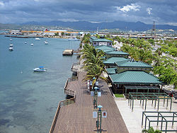
, Ponce - La Guancha Boardwalk, Ponce
- Hacienda Buena VistaHacienda Buena VistaHacienda Buena Vista, also known as Hacienda Vives , is a coffee plantation and estate in Ponce, Puerto Rico, established in the 19th century. The plantation was started by Don Salvador de Vives in 1833. It is now owned by the Puerto Rico Conservation Trust , who operates it as a museum...
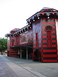
, Ponce - Historic FirehouseParque de BombasParque de Bombas is a historic firehouse building in Ponce, Puerto Rico. It is one of Puerto Rico's most notable buildings, with some considering it "by far the most easily recognized landmark in the Island". It is located at the Plaza Las Delicias town square, directly behind the Ponce Cathedral...
, Ponce - Serrallés CastleSerralles CastleSerrallés Castle is a mansion located in the city of Ponce, Puerto Rico overlooking the downtown area . It was built during the 1920s by Juan Eugenio Serrallés, son of businessman Juan Serrallés, founder of Destilería Serrallés...
, Ponce - Tibes - Native Indian MuseumTibes Indigenous Ceremonial CenterThe Tibes Indigenous Ceremonial Center in Barrio Portugués, Ponce, Puerto Rico, houses one of the most important archeological discoveries made in the Antilles. The discovery provides an insight as to how the indigenous tribes of the Igneri and Taínos lived and played during and before the arrival...
, Ponce
Other attractions
- Adjuntas
- Casa Pueblo
- Inabón waterfall
- Aibonito
- Casa Manresa
- La Trinchera de Asomante
- ArroyoArroyoArroyo is a Spanish word that may refer to:* Arroyo , an intermittently dry creek- People :Arts* Carlos Arroyo , Spanish architect* Martina Arroyo, American soprano* Eduardo Arroyo, Spanish painter...
- Faro Punta de las Figuras
- Tren del SurTren del SurThe Tren del Sur — or Train of the South in English — is a historic narrow gauge heritage railroad operating within the U.S. commonwealth of Puerto Rico in Arroyo...
- Coamo
- Los Baños de Coamo (Coamo Thermal Baths)
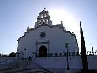
- Church San Blas de Illescas of CoamoChurch San Blas de Illescas of CoamoChurch San Blas de Illescas of Coamo is a Catholic parish church located on the center plaza of Coamo, Puerto Rico. Construction on the church began in 1661; it has since been judged one of the most important works of religious architecture in Puerto Rico. The church is separated from the open...
- Guayama
- Hacienda Azucarera Vives
- Carite Dam
- Guayanilla
- Mario Mercado CastleSerralles CastleSerrallés Castle is a mansion located in the city of Ponce, Puerto Rico overlooking the downtown area . It was built during the 1920s by Juan Eugenio Serrallés, son of businessman Juan Serrallés, founder of Destilería Serrallés...
- La Ventana Beach
- Mario Mercado Castle
- Jayuya
- Hacienda GripiñasHacienda GripiñasHacienda Gripiñas is a lodging located in the town of Jayuya, Puerto Rico.In 1863, Don Eusebio Pérez del Castillo established the Gripiñas hacienda in the sector of Gripiñas, barrio of Yeguitas, Jayuya. Gripiñas dedicated itself to the plantation of coffee and contributed to the growth of this...
- Toro Negro State ForestToro Negro State ForestToro Negro State Forest is one of the 16 state forests in Puerto Rico. The forest is located in the central region of the island. The forest covers 6,945 cuerdas of mountains, with heights that include Cerro de Punta, the highest peak in the island...
- Hacienda Gripiñas
- Juana Diaz
- Three Kings Festival
- Efraín Daleccio Caves
- PatillasPatillas, Puerto RicoPatillas is a municipality of Puerto Rico located in the southeastern coast, south of San Lorenzo; west of Yabucoa and Maunabo; and east of Guayama and Arroyo. It is spread over 15 wards and Patillas Pueblo...
- Parador Caribbean Paradise
- Villa Pesquera Beach
- Peñuelas
- Guilarte Forest
- Unknown Soldier Monument
- PoncePonce, Puerto RicoPonce is both a city and a municipality in the southern part of Puerto Rico. The city is the seat of the municipal government.The city of Ponce, the fourth most populated in Puerto Rico, and the most populated outside of the San Juan metropolitan area, is named for Juan Ponce de León y Loayza, the...
- Ponce Grand PrixPonce Grand PrixThe Ponce Grand Prix de Atletismo is a track and field competition held yearly in Ponce, Puerto Rico at the Francisco Montaner Stadium. The event started in 2007, after the successful hosting of the 2006 Ibero-American Championships.-Competitions:...
- Ponce Carnival
- Ponce Grand Prix
- SalinasSalinas, Puerto RicoSalinas is a small municipality in the southern part of Puerto Rico located in the southern coast of the island, south of Aibonito and Cayey; southeast of Coamo, east of Santa Isabel; and west of Guayama...
- Albergue OlímpicoAlbergue OlímpicoThe Albergue Olímpico German Rieckehoff Sampayo or Olympic Hostel is an athletic training and recreational center located in Salinas, Puerto Rico. It is the most complete sports center in Puerto Rico used by professional athletes and by the general public for health, educational, and recreational...
- Antigua Central Aguirre (Sugar Cane Mill)
- Albergue Olímpico
- Santa IsabelSanta Isabel, Puerto RicoSanta Isabel is a municipality of Puerto Rico located in the southern coast, south of Coamo; east of Juana Díaz; and west of Salinas. Santa Isabel is spread over 7 wards and Santa Isabel Pueblo...
- Jauca Beach
- Patron Celebrations
- Villaba
- Toro Negro Forest ReserveToro Negro State ForestToro Negro State Forest is one of the 16 state forests in Puerto Rico. The forest is located in the central region of the island. The forest covers 6,945 cuerdas of mountains, with heights that include Cerro de Punta, the highest peak in the island...
- Areyto Festival
- Toro Negro Forest Reserve
- Yauco
- Lake Luchetti
- National Coffee Festival (Festival Nacional del Café) - February
Similar groupings
In October 2011, Governor Luis Fortuno created what he called "Ruta del Sur" (English: Southern Route) in a political move to show support for the infrastructural development of the municipalities in southern Puerto Rico. Ruta del Sur included the nine municipalites of Guánica, Yauco, Ponce, Guayanilla, Peñuelas, Arroyo, Salinas, Juana Díaz y Santa Isabel. One of its goals is the development of ecotourism.DISUR, which stands for "Desarrollo Integral del Sur" (English: Southern Integral Development) is a private organization created in 2006 that seeks to "promote and maximize the competitiveness of the municipalities that make up the of southern region of Puerto Rico." It consists of 15 southern municipalities as follows: Adjuntas, Arroyo, Coamo, Guánica, Guayama, Guayanilla, Jayuya, Juana Díaz, Patillas, Peñuelas, Ponce, Salinas, Santa Isabel, Villalba y Yauco. The organization seeks to make strides in the area of turism by promoting conventions as well as the Centro Oceanografico de Ponce.
The College of Surveyors of Puerto Rico created the "Ruta Agrícola" (English: Agricultural Route) which runs from Salinas, through Santa Isabel and Juana Diaz, and ending in Ponce. Its purpose is "to create a new magnet for tourism".
See also
- National Register of Historic Places listings in Porta CaribeNational Register of Historic Places listings in southern Puerto RicoThis is a list of properties and districts in the southern municipalities of Puerto Rico that are listed on the National Register of Historic Places. It includes places along the southern coast, and on islands, and in the peaks and on the south slope of Puerto Rico's Cordillera Central.The area...
- Beaches of Porta Caribe