
Port Rickaby, South Australia
Encyclopedia
Port Rickaby is a coastal town on the Yorke Peninsula
in South Australia
.
Port Rickaby is in the District Council of Yorke Peninsula
, the state electoral district of Goyder
and federal
Division of Wakefield
.
. Thomas arrived in South Australia in 1858, joining the South Australian Mounted policy before resigning and settling on Yorke peninsula, and was the first president of the Minlanton Agricultural show.
The greater area served by the point is known as Koolywurtie, which has an Aboriginal translation of "Where rocks meet the sea".
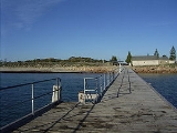
In 1879 a jetty was constructed to a length of 405 feet (123.4 m) at a cost of 1285 pounds. It was lengthened three times to a total length of 820 ft (249.9 m) in 1949.
The farmland served by the port was approximately 34000 acres (137.6 km²). Bagged grain was brought in horse drawn wagons, and later by motor truck to be weighed and stacked in large mouse-proof sheds and yards.
Much of the grain loaded into ketches, such as the Faile, Waimana, Coringle and Eva Lita was transferred into "WindJammers" with names such as the Passat, Kobenhaven and Pamir which were anchored off Pt.Victoria. These ships then made the overseas voyage via Cape horn to Europe. The last windjammer to leave was the Passat which departed on 2 June 1949. The last Windjammer to visit these waters was the five masted "Kobenhaven" in 1924 carrying 65000 bags of wheat (7091 tonnes)
The jetty was also used for the unloading of fencing materials, cement, stock, cornsacks, and all the necessary items needed for a new settlement.
In 1964 the government of the day shortened the jetty to save on repair costs.
Yorke Peninsula
The Yorke Peninsula is a peninsula located north-west and west of Adelaide in South Australia, Australia, between Spencer Gulf on the west and Gulf St Vincent on the east. It has geographic coordinates of...
in South Australia
South Australia
South Australia is a state of Australia in the southern central part of the country. It covers some of the most arid parts of the continent; with a total land area of , it is the fourth largest of Australia's six states and two territories.South Australia shares borders with all of the mainland...
.
Port Rickaby is in the District Council of Yorke Peninsula
District Council of Yorke Peninsula
The District Council of Yorke Peninsula is a local government area responsible for most of Yorke Peninsula in South Australia. The Council has 3 wards , Kalkabury, Gum Flat and Innes Pentonvale wards....
, the state electoral district of Goyder
Electoral district of Goyder
Goyder is an electoral district of the House of Assembly in the Australian state of South Australia. It is a 10,406.4 km² rural electorate based around the Yorke Peninsula and taking in the towns of Ardrossan, Bute, Corny Point, Edithburgh, Maitland, Minlaton, Moonta, Owen, Port Wakefield,...
and federal
Australian House of Representatives
The House of Representatives is one of the two houses of the Parliament of Australia; it is the lower house; the upper house is the Senate. Members of Parliament serve for terms of approximately three years....
Division of Wakefield
Division of Wakefield
The Division of Wakefield is an Australian Electoral Division in the state of South Australia. It is located north of Adelaide, incorporating the outer northern suburbs of Salisbury and Elizabeth, and extending north as far as Clare. It covers the east coast of the Gulf St Vincent north of...
.
History
In 1876 the port was established as a shipping place and named after Thomas Rickaby, an early pioneer from IrelandIreland
Ireland is an island to the northwest of continental Europe. It is the third-largest island in Europe and the twentieth-largest island on Earth...
. Thomas arrived in South Australia in 1858, joining the South Australian Mounted policy before resigning and settling on Yorke peninsula, and was the first president of the Minlanton Agricultural show.
The greater area served by the point is known as Koolywurtie, which has an Aboriginal translation of "Where rocks meet the sea".
In 1879 a jetty was constructed to a length of 405 feet (123.4 m) at a cost of 1285 pounds. It was lengthened three times to a total length of 820 ft (249.9 m) in 1949.
The farmland served by the port was approximately 34000 acres (137.6 km²). Bagged grain was brought in horse drawn wagons, and later by motor truck to be weighed and stacked in large mouse-proof sheds and yards.
Much of the grain loaded into ketches, such as the Faile, Waimana, Coringle and Eva Lita was transferred into "WindJammers" with names such as the Passat, Kobenhaven and Pamir which were anchored off Pt.Victoria. These ships then made the overseas voyage via Cape horn to Europe. The last windjammer to leave was the Passat which departed on 2 June 1949. The last Windjammer to visit these waters was the five masted "Kobenhaven" in 1924 carrying 65000 bags of wheat (7091 tonnes)
The jetty was also used for the unloading of fencing materials, cement, stock, cornsacks, and all the necessary items needed for a new settlement.
In 1964 the government of the day shortened the jetty to save on repair costs.