
Porongurup, Western Australia
Encyclopedia
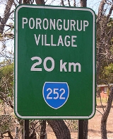
Porongurup is the name of a small mountain range in the Shire of Plantagenet in Western Australia
(see Porongurup National Park
for information about the range itself) and of a small village on the northern slopes of the range. At the 2006 census
, Porongurup had a population of 370.
The name is derived from the Aboriginal place-name, and consequently arrived with no spelling as such. A common alternate spelling is Porongorup and while some maps still show this spelling, state government signs around the town use "Porongurup", as does the promotion association for the region.
The range includes Castle Rock
, a popular climbing destination, and the Devils Slide.
forests is limited by the difficulty of access because the nearest public transport is in Albany
or Mount Barker
.
 As with other parts of the Lower Great Southern region of Western Australia
, silviculture
, specifically plantations of Tasmanian Blue Gums
(Eucalyptus globulus), is becoming a notable, and sometimes controversial, industry in Porongurup.
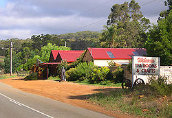
Viticulture is a relatively young but flourishing industry in the region with eleven local wineries listed on the Porongurup Promotion Association web-page at time of writing (March, 2007). The very popular Porongurup Wine Festival is held at a different local winery each year in March.
Another increasingly popular annual event is 'Art in the Park', an outdoor sculpture competition in the picnic area on Castle Rock Road in the national park. The week-long event is held in April and attracts a diverse range of traditional and contemporary works vying for cash prizes.
were released in the Porongurup Range by the Department of Environment and Conservation, Western Australia, as part of a trans-location program for the conservation
of this endangered species.
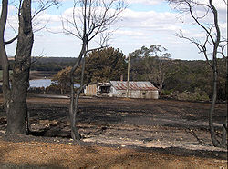 On 11 February 2007, a fire began on private property near the north-west corner of the national park, around eight kilometres west of the Porongurup village. The fire spread along the rear boundaries of several properties and into the national park. Fire crews helped prevent the fire spreading to nearby housing throughout Sunday night but on Monday afternoon (12 February) it jumped Porongurup-Mt Barker Road and spread into private property to the north-east of the village centre. One private residence and a number of farm sheds and buildings were destroyed and other buildings seriously damaged in the fire. Fire crews, including aerial support from six water bomber planes
, battled the blaze and by Tuesday morning it was effectively under control. By Wednesday morning (14 February) the fire had burnt through around 95% of the national park and several farms and wineries showed the scars of the fire.
It was reportedly the most devastating fire in the region since the 1960s. Less than a week after the fire began, a committee was formed to take charge of remedial work in the community and in a show of resilience, local wineries still held their annual wine festival a few weeks later. Despite the national park remaining closed to visitors, the annual Art in the Park exhibition was allowed to go ahead in early April.
Sections of the park, including the Castle Rock walk trail and the Tree in The Rock picnic area, were reopened to the general public in September 2007.
Western Australia
Western Australia is a state of Australia, occupying the entire western third of the Australian continent. It is bounded by the Indian Ocean to the north and west, the Great Australian Bight and Indian Ocean to the south, the Northern Territory to the north-east and South Australia to the south-east...
(see Porongurup National Park
Porongurup National Park
Porongurup National Park is a national park in the Great Southern region of Western Australia , 360 km southeast of Perth and 40 km from Albany....
for information about the range itself) and of a small village on the northern slopes of the range. At the 2006 census
Census in Australia
The Australian census is administered once every five years by the Australian Bureau of Statistics. The most recent census was conducted on 9 August 2011; the next will be conducted in 2016. Prior to the introduction of regular censuses in 1961, they had also been run in 1901, 1911, 1921, 1933,...
, Porongurup had a population of 370.
The name is derived from the Aboriginal place-name, and consequently arrived with no spelling as such. A common alternate spelling is Porongorup and while some maps still show this spelling, state government signs around the town use "Porongurup", as does the promotion association for the region.
The range includes Castle Rock
Castle Rock, Western Australia
Castle Rock is a tourist attraction in the Porongurup Range in the Great Southern region of Western Australia and is renowned for its fauna and flora.There is a walk trail to the summit which offers 360 degree views, above sea level...
, a popular climbing destination, and the Devils Slide.
Industry
The main industry in the region is dairying, but there are some vegetable crops grown as well. Tourism based on the Porongurup Range's giant karriKarri
Eucalyptus diversicolor, commonly known as the Karri, is a eucalypt which is native to the wetter regions of south west of Western Australia.-Description:...
forests is limited by the difficulty of access because the nearest public transport is in Albany
Albany, Western Australia
Albany is a port city in the Great Southern region of Western Australia, some 418 km SE of Perth, the state capital. As of 2009, Albany's population was estimated at 33,600, making it the 6th-largest city in the state....
or Mount Barker
Mount Barker, Western Australia
Mount Barker is a town on the Albany Highway and is the administrative centre of the Shire of Plantagenet in the Great Southern region of Western Australia...
.
Western Australia
Western Australia is a state of Australia, occupying the entire western third of the Australian continent. It is bounded by the Indian Ocean to the north and west, the Great Australian Bight and Indian Ocean to the south, the Northern Territory to the north-east and South Australia to the south-east...
, silviculture
Silviculture
Silviculture is the practice of controlling the establishment, growth, composition, health, and quality of forests to meet diverse needs and values. The name comes from the Latin silvi- + culture...
, specifically plantations of Tasmanian Blue Gums
Eucalyptus globulus
The Tasmanian Blue Gum, Southern Blue Gum or Blue Gum, is an evergreen tree, one of the most widely cultivated trees native to Australia. They typically grow from 30 to 55 m tall. The tallest currently known specimen in Tasmania is 90.7 m tall...
(Eucalyptus globulus), is becoming a notable, and sometimes controversial, industry in Porongurup.
Viticulture is a relatively young but flourishing industry in the region with eleven local wineries listed on the Porongurup Promotion Association web-page at time of writing (March, 2007). The very popular Porongurup Wine Festival is held at a different local winery each year in March.
Another increasingly popular annual event is 'Art in the Park', an outdoor sculpture competition in the picnic area on Castle Rock Road in the national park. The week-long event is held in April and attracts a diverse range of traditional and contemporary works vying for cash prizes.
Wine region
- Porongurup is the fifth of the subregions of Great Southern, somewhat untidily locking into Mount Barker on its western boundary. Eucalypt forest and rounded granite knobs and boulders give way to views out over the stirlings in one part, and towards Esperance in another. Lat: 34 10’S; Alt: 259–300 m; Hdd: 1441; Gsr: 310 mm; Mjt: 19C; Harvest: Mid-March to early May; Chief Viticultural Hazard: birds.
Environment
In July and August 2006 eight Noisy Scrub-birdsScrub-bird
Scrub-birds are shy, secretive, ground-dwelling birds of the family Atrichornithidae. There are just two species. The Rufous scrub-bird is rare and very restricted in its range, and the Noisy scrub-bird is so rare that until 1961 it was thought to be extinct...
were released in the Porongurup Range by the Department of Environment and Conservation, Western Australia, as part of a trans-location program for the conservation
Wildlife conservation
Wildlife conservation is the preservation, protection, or restoration of wildlife and their environment, especially in relation to endangered and vulnerable species. All living non-domesticated animals, even if bred, hatched or born in captivity, are considered wild animals. Wildlife represents all...
of this endangered species.
History
Aerial firefighting
Aerial firefighting is the use of aircraft and other aerial resources to combat wildfires. The types of aircraft used include fixed-wing aircraft and helicopters. Smokejumpers and rappellers are also classified as aerial firefighters, delivered to the fire by parachute from a variety of fixed-wing...
, battled the blaze and by Tuesday morning it was effectively under control. By Wednesday morning (14 February) the fire had burnt through around 95% of the national park and several farms and wineries showed the scars of the fire.
It was reportedly the most devastating fire in the region since the 1960s. Less than a week after the fire began, a committee was formed to take charge of remedial work in the community and in a show of resilience, local wineries still held their annual wine festival a few weeks later. Despite the national park remaining closed to visitors, the annual Art in the Park exhibition was allowed to go ahead in early April.
Sections of the park, including the Castle Rock walk trail and the Tree in The Rock picnic area, were reopened to the general public in September 2007.