

Point Lay, Alaska
Encyclopedia
Point Lay is a census-designated place
(CDP) in North Slope Borough, Alaska
, United States. At the 2000 census the population was 247.
.
According to the United States Census Bureau
, the CDP has a total area of 34.5 square miles (89.4 km²), of which, 30.5 square miles (79 km²) of it is land and 4 square miles (10.4 km²) of it (11.66%) is water.
Point Lay once was on a barrier island of Kasegaluk Lagoon
, but moved to the mainland near the mouth of the Kokolik River
during the 1970s. http://appropriations.senate.gov/hearmarkups/record.cfm?id=223525
, 82.59% Native American
, 0.40% Asian
, and 5.67% from two or more races. 2.43% of the population were Hispanic
or Latino
of any race.
There were 61 households out of which 50.8% had children under the age of 18 living with them, 45.9% were married couples living together, 18.0% had a female householder with no husband present, and 24.6% were non-families. 23.0% of all households were made up of individuals and 1.6% had someone living alone who was 65 years of age or older. The average household size was 3.93 and the average family size was 4.57.
In the CDP the age distribution of the population shows 46.2% under the age of 18, 9.3% from 18 to 24, 24.7% from 25 to 44, 17.0% from 45 to 64, and 2.8% who were 65 years of age or older. The median age was 21 years. For every 100 females there were 135.2 males. For every 100 females age 18 and over, there were 133.3 males.
The median income for a household in the CDP was $68,750, and the median income for a family was $75,883. Males had a median income of $46,071 versus $25,625 for females. The per capita income
for the CDP was $18,003. About 11.4% of families and 7.4% of the population were below the poverty line, including 8.1% of those under the age of eighteen and none of those sixty five or over.
. On the Fourth of July, a parade runs through town led by the fire engines and ambulances of the town's modern fire department.
The Eskimo name for the village was Kali, which means "mound", after a raised area on the barrier island where the old village stood. The school and fire department bear the name Kali.
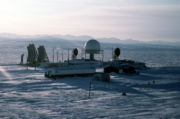 Until recently, a cluster of radar dishes existed near Point Lay. These were a part of the Distant Early Warning Line
, a system of defensive radar installations built during the Cold War
. The station was decommissioned during the 1990s, and the radar dishes were dismantled sometime between 2004 and 2006.
Census-designated place
A census-designated place is a concentration of population identified by the United States Census Bureau for statistical purposes. CDPs are delineated for each decennial census as the statistical counterparts of incorporated places such as cities, towns and villages...
(CDP) in North Slope Borough, Alaska
North Slope Borough, Alaska
-National protected areas:* Alaska Maritime National Wildlife Refuge ** Cape Lisburne** Cape Thompson* Arctic National Wildlife Refuge ** Mollie Beattie Wilderness * Gates of the Arctic National Park and Preserve...
, United States. At the 2000 census the population was 247.
Geography
Point Lay is located at 69°44′28"N 163°0′31"W (69.741023, -163.008613) on the shores of the Chukchi SeaChukchi Sea
Chukchi Sea is a marginal sea of the Arctic Ocean. It is bounded on the west by the De Long Strait, off Wrangel Island, and in the east by Point Barrow, Alaska, beyond which lies the Beaufort Sea. The Bering Strait forms its southernmost limit and connects it to the Bering Sea and the Pacific...
.
According to the United States Census Bureau
United States Census Bureau
The United States Census Bureau is the government agency that is responsible for the United States Census. It also gathers other national demographic and economic data...
, the CDP has a total area of 34.5 square miles (89.4 km²), of which, 30.5 square miles (79 km²) of it is land and 4 square miles (10.4 km²) of it (11.66%) is water.
Point Lay once was on a barrier island of Kasegaluk Lagoon
Kasegaluk Lagoon
The Kasegaluk Lagoon is a coastal lagoon located in the western part of the North Slope of Alaska. It is separated from the Chukchi Sea by a series of long, thin barrier islands that stretch south and north-east from the town of Point Lay and westwards down to Icy Cape. There are seven passes...
, but moved to the mainland near the mouth of the Kokolik River
Kokolik River
The Kokolik River is a river in Alaska's North Slope flowing into the Chukchi Sea.Its Inuit name was reported by Lt. D. H. Jarvis, USRCS, in 1898. A. J. Collier, USGS, reported the name "Kepizetka", probably obtained from the so-called Cullinghow's map of Cape Lisburne, a manuscript map drawn by an...
during the 1970s. http://appropriations.senate.gov/hearmarkups/record.cfm?id=223525
Demographics
As of the census of 2000, there were 247 people, 61 households, and 45 families residing in the CDP. The population density was people per square mile (/km2). There were 67 housing units at an average density of per square mile (/km2). The racial makeup of the CDP was 11.34% WhiteRace (United States Census)
Race and ethnicity in the United States Census, as defined by the Federal Office of Management and Budget and the United States Census Bureau, are self-identification data items in which residents choose the race or races with which they most closely identify, and indicate whether or not they are...
, 82.59% Native American
Race (United States Census)
Race and ethnicity in the United States Census, as defined by the Federal Office of Management and Budget and the United States Census Bureau, are self-identification data items in which residents choose the race or races with which they most closely identify, and indicate whether or not they are...
, 0.40% Asian
Race (United States Census)
Race and ethnicity in the United States Census, as defined by the Federal Office of Management and Budget and the United States Census Bureau, are self-identification data items in which residents choose the race or races with which they most closely identify, and indicate whether or not they are...
, and 5.67% from two or more races. 2.43% of the population were Hispanic
Race (United States Census)
Race and ethnicity in the United States Census, as defined by the Federal Office of Management and Budget and the United States Census Bureau, are self-identification data items in which residents choose the race or races with which they most closely identify, and indicate whether or not they are...
or Latino
Race (United States Census)
Race and ethnicity in the United States Census, as defined by the Federal Office of Management and Budget and the United States Census Bureau, are self-identification data items in which residents choose the race or races with which they most closely identify, and indicate whether or not they are...
of any race.
There were 61 households out of which 50.8% had children under the age of 18 living with them, 45.9% were married couples living together, 18.0% had a female householder with no husband present, and 24.6% were non-families. 23.0% of all households were made up of individuals and 1.6% had someone living alone who was 65 years of age or older. The average household size was 3.93 and the average family size was 4.57.
In the CDP the age distribution of the population shows 46.2% under the age of 18, 9.3% from 18 to 24, 24.7% from 25 to 44, 17.0% from 45 to 64, and 2.8% who were 65 years of age or older. The median age was 21 years. For every 100 females there were 135.2 males. For every 100 females age 18 and over, there were 133.3 males.
The median income for a household in the CDP was $68,750, and the median income for a family was $75,883. Males had a median income of $46,071 versus $25,625 for females. The per capita income
Per capita income
Per capita income or income per person is a measure of mean income within an economic aggregate, such as a country or city. It is calculated by taking a measure of all sources of income in the aggregate and dividing it by the total population...
for the CDP was $18,003. About 11.4% of families and 7.4% of the population were below the poverty line, including 8.1% of those under the age of eighteen and none of those sixty five or over.
Lifestyle and Economy
The village has an annual hunt of Beluga Whales within the Kasegaluk LagoonKasegaluk Lagoon
The Kasegaluk Lagoon is a coastal lagoon located in the western part of the North Slope of Alaska. It is separated from the Chukchi Sea by a series of long, thin barrier islands that stretch south and north-east from the town of Point Lay and westwards down to Icy Cape. There are seven passes...
. On the Fourth of July, a parade runs through town led by the fire engines and ambulances of the town's modern fire department.
The Eskimo name for the village was Kali, which means "mound", after a raised area on the barrier island where the old village stood. The school and fire department bear the name Kali.
Military Radar
Distant Early Warning Line
The Distant Early Warning Line, also known as the DEW Line or Early Warning Line, was a system of radar stations in the far northern Arctic region of Canada, with additional stations along the North Coast and Aleutian Islands of Alaska, in addition to the Faroe Islands, Greenland, and Iceland...
, a system of defensive radar installations built during the Cold War
Cold War
The Cold War was the continuing state from roughly 1946 to 1991 of political conflict, military tension, proxy wars, and economic competition between the Communist World—primarily the Soviet Union and its satellite states and allies—and the powers of the Western world, primarily the United States...
. The station was decommissioned during the 1990s, and the radar dishes were dismantled sometime between 2004 and 2006.
External links
- Information about Point Lay from the North Slope Borough
- Information about Point Lay from the North Slope Borough School District
- Current Weather Conditions at the Point Lay Airport, by the National Weather Service