

Kasegaluk Lagoon
Encyclopedia
Lagoon
A lagoon is a body of shallow sea water or brackish water separated from the sea by some form of barrier. The EU's habitat directive defines lagoons as "expanses of shallow coastal salt water, of varying salinity or water volume, wholly or partially separated from the sea by sand banks or shingle,...
located in the western part of the North Slope
North Slope Borough, Alaska
-National protected areas:* Alaska Maritime National Wildlife Refuge ** Cape Lisburne** Cape Thompson* Arctic National Wildlife Refuge ** Mollie Beattie Wilderness * Gates of the Arctic National Park and Preserve...
of Alaska
Alaska
Alaska is the largest state in the United States by area. It is situated in the northwest extremity of the North American continent, with Canada to the east, the Arctic Ocean to the north, and the Pacific Ocean to the west and south, with Russia further west across the Bering Strait...
. It is separated from the Chukchi Sea
Chukchi Sea
Chukchi Sea is a marginal sea of the Arctic Ocean. It is bounded on the west by the De Long Strait, off Wrangel Island, and in the east by Point Barrow, Alaska, beyond which lies the Beaufort Sea. The Bering Strait forms its southernmost limit and connects it to the Bering Sea and the Pacific...
by a series of long, thin barrier islands that stretch south and north-east from the town of Point Lay
Point Lay, Alaska
Point Lay is a census-designated place in North Slope Borough, Alaska, United States. At the 2000 census the population was 247.-Geography:Point Lay is located at on the shores of the Chukchi Sea....
and westwards down to Icy Cape
Icy Cape, Alaska
The Icy Cape is a headland on the Chukchi Sea side of the North Slope Borough, Alaska, United States. It was discovered and named by James Cook on August 17, 1778....
. There are seven passes through these islands. The lagoon receives the waters from the Kukpowruk
Kukpowruk River
The Kukpowruk River is a 160 mile long river in North Slope Borough, Alaska, United States, which flows into the Chukchi Sea. Arctic Slope Regional Corporation is the major landowner along the river....
, Kokolik
Kokolik River
The Kokolik River is a river in Alaska's North Slope flowing into the Chukchi Sea.Its Inuit name was reported by Lt. D. H. Jarvis, USRCS, in 1898. A. J. Collier, USGS, reported the name "Kepizetka", probably obtained from the so-called Cullinghow's map of Cape Lisburne, a manuscript map drawn by an...
, and Utukok
Utukok River
The Utukok River is a long river in the North Slope Borough of the U.S. state of Alaska that flows into the Chukchi Sea.Rising at in the De Long Mountains at the confluence of Kogruk Creek and Tupik Creek and flowing north, northeast, and then northwest, to Kasegaluk Lagoon and the Arctic Ocean, ...
Rivers.
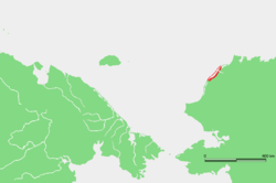
Kasegaluk Lagoon extends for about 200 km (124.3 mi), from approximately 69°16′N 163°15′W to 70°22′N 160°47′W.
The lagoon's Inuit
Inuit
The Inuit are a group of culturally similar indigenous peoples inhabiting the Arctic regions of Canada , Denmark , Russia and the United States . Inuit means “the people” in the Inuktitut language...
name was formerly reported as "Kasegarlik" but it was changed in 1929 to its present spelling. In 1965, at Wainwright
Wainwright
A wainwright is a tradesperson skilled in the making and repairing of wagons . The word is the combination of the archaic words "wain" and "wright" .In places:*Canada...
, the lagoon's name was recorded as "Kasegelik," meaning "spotted seal
Spotted Seal
The spotted seal , also known as the larga or largha seal, is a member of the family Phocidae, and is considered a "true seal". It inhabits ice floes and waters of the north Pacific Ocean and adjacent seas...
place" or "having spotted seal."
External links
- Google Maps: Map, Satellite Image
- Topozone Maps: http://www.topozone.com/map.asp?lat=69.49748&lon=-163.09477&s=1000&size=l&u=7&datum=nad27&layer=DRG250, http://www.topozone.com/map.asp?lat=69.80324&lon=-162.96955&s=1000&size=l&u=7&datum=nad27&layer=DRG250, http://www.topozone.com/map.asp?lat=70.20441&lon=-162.11241&s=1000&size=l&u=7&datum=nad27&layer=DRG250
- Diagramatic map available on Page 40 of Lowry, L.F., K.J. Frost, R. Davis, R.S. Suydam, and D.P. DeMaster. 1994.
- U.S. Dept. of Commerce NOAA Tech. Memo. NMFS-AFSC-38, 71 pages.