
Podilsko-Voskresenska Line
Encyclopedia
The Podilsko-Vyhurivska Line formerly the Podilsko-Voskresenska Line will be the fourth addition to Kiev
's metro system
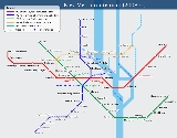
. Presently under construction, when finished, it will contain 16 stations and be approximately 20 kilometers long. This line will serve as an important relief for existing and over-stretched transfer points. The first segment is due to open between 2010 and 2015, with the project being fully completed by 2025. This line is coloured orange on the maps.
station of the Sviatoshynsko-Brovarska Line
northwards to Hlybochytska, which will be a transfer to the Lukianivska
station on the Syretsko-Pecherska Line
. The second segment will then continue eastwards to the Podil
region of Kiev, across the Dnieper River
on a combined automobile bridge through Trukhaniv Island
, and into the northern left-bank districts. Most of the second segment's stations will be shallow-level or elevated.
Even though the Vokzalna-Hlybochytska segment is planned to open first, it is also likely that the first stage segments described above will open in the opposite order. This is because at present the new bridge
, currently under construction, is of top importance to relieve automobile congestion. However, in doing so, the already laiden Kurenivsky
radius of the Kurenivsko-Chervonoarmiyska Line
, on which carries the passengers from the Obolon
district, will now add those travelling to and from Troyeshchyna. The two districts are largest in Kiev and there are serious concerns about the older line being able to handle the new increase in the passenger load, thus it is more likely that the whole first stage will open simultaneously.
all the way across to Kiev-Zhulyany Airport and the residential districts on the circular highway. The northeastern extension is slightly more complex, as the line will split. The first branch will continue east with two stations to Bratislavska, parallel with the existing Sviatoshynsko-Brovarska Line. The second, northern branch will annex the whole of Kiev fast tram
's #2 route, converted it to Metro standards. It is expected that the branch system will be in operation until the future Livoberezhna Line
will take the northern branch off the Podilsko-Vyhurivska in mid 2030s.
Kiev
Kiev or Kyiv is the capital and the largest city of Ukraine, located in the north central part of the country on the Dnieper River. The population as of the 2001 census was 2,611,300. However, higher numbers have been cited in the press....
's metro system
Kiev Metro
The Kiev Metro is a metro system that is the mainstay of Kiev's public transport. It was the first rapid transit system in Ukraine and the third one built in the USSR . It now has three lines with a total length of 63.7 kilometres and 49 stations...
. Presently under construction, when finished, it will contain 16 stations and be approximately 20 kilometers long. This line will serve as an important relief for existing and over-stretched transfer points. The first segment is due to open between 2010 and 2015, with the project being fully completed by 2025. This line is coloured orange on the maps.
Plan and construction
Like most Kiev Metro lines, it will open in a set of stages. The first is planned to be a three-station deep-level segment which will run from the existing VokzalnaVokzalna (Kiev Metro)
Vokzalna is a station on Kiev Metro's Sviatoshynsko-Brovarska Line. The station was opened along with the Metro on the 6 November 1960, and is named after Kiev's Central rail station and is the metro stop for those using the train....
station of the Sviatoshynsko-Brovarska Line
Sviatoshynsko-Brovarska Line
The Sviatoshynsko-Brovarska Line , is the first line of the Kiev Metro, dating back to 1960. It includes some of the system's more historically significant stations, like Arsenalna, which at 105.5 meters is the deepest in the world and the next station Dnipro, which although the tunnel follows a...
northwards to Hlybochytska, which will be a transfer to the Lukianivska
Lukianivska (Kiev Metro)
Lukianivska is a station on Kiev Metro's Syretsko-Pecherska Line. The station was opened on December 30, 1996, as part of the first stage extension of the Syretsky radius....
station on the Syretsko-Pecherska Line
Syretsko-Pecherska Line
The Syretsko-Pecherska Line is third line of the Kiev Metro, first opened in 1989. It extends the metro system southeast along the right bank of the Dnieper River before crossing it on a covered bridge and then east from there. The northern section extends further northwestwards. The line is one...
. The second segment will then continue eastwards to the Podil
Podil
The Podil or Podilskyi Raion is a historic neighbourhood and an administrative raion in Kiev, the capital of Ukraine. It is one of the oldest neighborhoods of Kiev, the birthplace of the city's trade, commerce and industry...
region of Kiev, across the Dnieper River
Dnieper River
The Dnieper River is one of the major rivers of Europe that flows from Russia, through Belarus and Ukraine, to the Black Sea.The total length is and has a drainage basin of .The river is noted for its dams and hydroelectric stations...
on a combined automobile bridge through Trukhaniv Island
Trukhaniv Island
Trukhaniv Island is an island located on the Dnieper River opposite the historic Podil neighbourhood of the city of Kiev. It has an area of . The island is mostly covered by greenery, like the Hidropark island nearby. Until 1957, the only method of transportation to the island was by boat in the...
, and into the northern left-bank districts. Most of the second segment's stations will be shallow-level or elevated.
Even though the Vokzalna-Hlybochytska segment is planned to open first, it is also likely that the first stage segments described above will open in the opposite order. This is because at present the new bridge
Bridges in Kiev
Kiev, that historically was situated on the right bank of the Dnieper River, since 1925-27 covers both banks of the river whose width, as it flows through the city, reaches some several hundred metres. Additionally, several tributaries fall into the Dnieper inside or just north or south of the...
, currently under construction, is of top importance to relieve automobile congestion. However, in doing so, the already laiden Kurenivsky
Kurenivka
Kurenivka or Kurenyovka is a historical neighbourhood on the right bank of Kiev, the capital of Ukraine. It is located between the neighbourhoods of Podil, Obolon, Priorka, and Syrets....
radius of the Kurenivsko-Chervonoarmiyska Line
Kurenivsko-Chervonoarmiyska Line
The Kurenivsko-Chervonoarmiyska Line , is the second line of the Kiev Metro, first opened in 1976, it extended northwards along the right bank of the Dnieper river and began deviating from the river towards the southwest. As the current stations were built in the 1970s and 80s, architecturally the...
, on which carries the passengers from the Obolon
Obolon
Obolon may refer to:* Obolon Raion, a district of Ukraine's capital city, Kiev* Obolon CJSC, the largest Ukrainian brewer* FC Obolon Kyiv, a soccer club based in Kiev* Obolon , a metro station...
district, will now add those travelling to and from Troyeshchyna. The two districts are largest in Kiev and there are serious concerns about the older line being able to handle the new increase in the passenger load, thus it is more likely that the whole first stage will open simultaneously.
Opening schedule
The first stage will be followed by two subsequent extensions. The first one will be the Voskresenky radius to the southwest, with five stations. It will continue the line from the Railway station through the Solomianskyi RaionSolomianskyi Raion
Solomianskyi Raion is an administrative raion of the city of Kiev, the capital of Ukraine....
all the way across to Kiev-Zhulyany Airport and the residential districts on the circular highway. The northeastern extension is slightly more complex, as the line will split. The first branch will continue east with two stations to Bratislavska, parallel with the existing Sviatoshynsko-Brovarska Line. The second, northern branch will annex the whole of Kiev fast tram
Kiev tram
The Kiev Tramway is a tram network which serves the Ukrainian capital Kiev. The system was the first electric tramway in the former Russian Empire and the third one in Europe after the Berlin Straßenbahn and the Budapest tramway. The system currently consists of 139.9 km of track, including...
's #2 route, converted it to Metro standards. It is expected that the branch system will be in operation until the future Livoberezhna Line
Livoberezhna Line
Livoberezhna Line is a proposed fifth rapid transit line of the Kiev Metro, planned to be serving the left bank area of Dnieper River of capital Kiev, Ukraine. The line is coloured light sky blue on the maps. It will have transfer stations with intercity railway stations and other metro lines...
will take the northern branch off the Podilsko-Vyhurivska in mid 2030s.