

Playa (Ponce)
Encyclopedia
La Playa de Ponce, Ponce Playa, La Playa, or simply Playa, is one of the thirty-one barrio
s that comprise the municipality
of Ponce, Puerto Rico
. Along with Bucaná
, Canas
, Vayas
, and Capitanejo
, Playa is one of the municipality's five coastal barrios. Barrio Playa also incorporates several islands, the largest of which is Caja de Muertos
.
, and on the shores of the Caribbean Sea
. It is located at 17.9839°N 66.6128°W, and it has an elevation of 10 feet.
, on the South by the Caribbean Sea
, on the West by Río Matilde
, and on the East by Río Bucaná
.
In terms of barrio-to-barrio boundaries, Playa is bounded in the North by Canas Urbano
and San Anton
, in the South by the Caribbean Sea
, in the West by Canas
, and in the East by Bucaná
.
. Playa has 4.6 square miles (11.9 km²) of land area and no water area.
In 2000, the population of Playa was 4,761 persons, and it had a density of 1,031 persons per square mile. The communities of Villa del Carmen, Valle Real, Villa Tabaiba, Salistral, El Caribe, Puerto Viejo, Los Meros, Amalia Marin, Lirios del Sur, and Playa proper are found here.
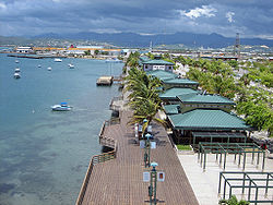
This barrio, or ward, has its own plaza
giving it the character of a municipality within a municipality. It has a residential area, a tourist area called La Guancha
, and a harbor, Puerto de Ponce
.
Playa has the second longest coastline of all five coastal barrios in Ponce, after Canas
.
to warn the city of the need of help in the Playa harbor, a port settlement at the time.
By the 1830s, la Playa had one of the best roads in Puerto Rico, connecting the shore settlement to the city proper, and it was the center of Ponce's commercial activity. It subsequently also got the first phone lines in Ponce and was also the first one to get railroad service from downtown Ponce.
Unfortunately, in 1845 a significant fire occurred in La Playa. The fire destroyed Playa and most of the Ponce vicinity. It significantly damaged the Spanish Customs House in Ponce, this being one of the few building left standing after the fire. The fire burned down the major buildings of the "Marina de Ponce". This moved Puerto Rico governor Conde de Marisol to create a new voluntary fire-fighting organization island-wide.
In 1887 the Spanish government built a lighthouse at Caja de Muertos Light
on an island by the same name just off the coast of barrio Playa. This was followed by the building of Cayo Cardona
lighthouse in 1889, on a small island at the entrance of the Ponce harbor. Both of these islands are part of barrio Playa.
By 1913, Playa was "a dynamic neighborhood with a self-substained urban development with a population of 5,169 distributed through a residential area dominated by wooden houses, sugar cane farms, churches, schools, hospitals, a cemetery and local indiustries that promoted the formation of a strong artisan and industrial workers class."
In 1929, La Playa was the place where Dr. Manuel de la Pila Iglesias
worked for the U.S. federal government with such distinction as to earn him the title "physician of physicians."
Today, Playa is a mostly low-income barrio of Ponce, and thus this is where Isolina Ferré
founded her "Centro de Orientacion de la Playa" hospital and school that would earn her the U.S. Presidential Medal of Freedom
in 1999. The Ponce Playa Diagnostic and Treatment Center was also founded in barrio Playa de Ponce.
foundry, Plaza del Caribe
mall, Club Náutico de Ponce
yacht club, La Guancha boardwalk, and Coffin Island
natural reserve are all located in Barrio Playa.
The historic Cardona Island Light
, Caja de Muertos Lighthouse, Cardona Island Lighthouse, and US Custom House and McCabe Memorial Church
, all NRHP-listed landmarks, are also located in Barrio Playa.
Playa also has the most important Caribbean seaport in Puerto Rico, called Port of the Americas
.
Barrio
Barrio is a Spanish word meaning district or neighborhood.-Usage:In its formal usage in English, barrios are generally considered cohesive places, sharing, for example, a church and traditions such as feast days...
s that comprise the municipality
Municipality
A municipality is essentially an urban administrative division having corporate status and usually powers of self-government. It can also be used to mean the governing body of a municipality. A municipality is a general-purpose administrative subdivision, as opposed to a special-purpose district...
of Ponce, Puerto Rico
Ponce, Puerto Rico
Ponce is both a city and a municipality in the southern part of Puerto Rico. The city is the seat of the municipal government.The city of Ponce, the fourth most populated in Puerto Rico, and the most populated outside of the San Juan metropolitan area, is named for Juan Ponce de León y Loayza, the...
. Along with Bucaná
Bucaná
Bucaná is one of the 31 barrios of the municipality of Ponce, Puerto Rico. Together with Canas, Playa, Vayas, and Capitanejo, Bucaná is one of the municipality's five coastal barrios...
, Canas
Canas (Ponce)
Canas is one of the 31 barrios in the municipality of Ponce, Puerto Rico. Along with Anón, Coto Laurel, Guaraguao, Quebrada Limón, Real, San Patricio, and Marueño, and the coastal barrio of Capitanejo, Canas is one of the municipality's nine bordering barrios. It borders the municipality of...
, Vayas
Vayas
Vayas is one of the 31 barrios of the municipality of Ponce, Puerto Rico. Along with Playa, Bucana, Canas and Capitanejo, Vayas is also one of Ponce's five coastal barrios...
, and Capitanejo
Capitanejo (Ponce)
Capitanejo is one of the 31 barrios of the municipality of Ponce, Puerto Rico. Along with Anón, Coto Laurel, Guaraguao, Quebrada Limón, Real, San Patricio, and Marueño, and the coastal barrio of Canas, Capitanejo is one of the municipality's nine bordering barrios. It borders the municipality of...
, Playa is one of the municipality's five coastal barrios. Barrio Playa also incorporates several islands, the largest of which is Caja de Muertos
Caja de Muertos, Puerto Rico
Caja de Muertos is an uninhabited island off the southern coast of Puerto Rico, in the municipality of Ponce. The island is protected by the Reserva Natural Caja de Muertos natural reserve, because of its native turtle traffic...
.
Location
Playa is an urban barrio located in the southern region of the municipality, within the limits of the city of Ponce, south of the traditional center of the city at Plaza Las DeliciasPlaza Las Delicias
Plaza Las Delicias is the main plaza in the city of Ponce, Puerto Rico. The square is notable for its fountains and for the various monuments it contains. The historic Parque de Bombas and Ponce Cathedral buildings are located within Plaza Las Delicias. Plaza Las Delicias is actually composed of...
, and on the shores of the Caribbean Sea
Caribbean Sea
The Caribbean Sea is a sea of the Atlantic Ocean located in the tropics of the Western hemisphere. It is bounded by Mexico and Central America to the west and southwest, to the north by the Greater Antilles, and to the east by the Lesser Antilles....
. It is located at 17.9839°N 66.6128°W, and it has an elevation of 10 feet.
Boundaries
It is bounded on the North by PR-2Puerto Rico Highway 2
Puerto Rico Highway 2, the longest highway in the Commonwealth of Puerto Rico at about 156 miles long, connects San Juan to Ponce....
, on the South by the Caribbean Sea
Caribbean Sea
The Caribbean Sea is a sea of the Atlantic Ocean located in the tropics of the Western hemisphere. It is bounded by Mexico and Central America to the west and southwest, to the north by the Greater Antilles, and to the east by the Lesser Antilles....
, on the West by Río Matilde
Río Matilde
The Río Matilde is a short river in the municipality of Ponce, Puerto Rico. It forms from the confluence of Rio Pastillo and Rio Canas This river is one of the 14 rivers in the municipality and, forming at an altitude of just , it is the river forming at the lowest altitute in Ponce.-Origin:At ...
, and on the East by Río Bucaná
Río Bucaná
Río Bucaná, is a river in the municipality of Ponce, Puerto Rico. Rio Bucana has its origin in barrio Machuelo Arriba where it forms at an altitude of . It forms from the confluence of Rio Cerrillos and Rio Bayagan. It is also fed by Rio Portugues during its southernly run. Rio Bucana used to run...
.
In terms of barrio-to-barrio boundaries, Playa is bounded in the North by Canas Urbano
Canas Urbano
Canas Urbano is one of the 31 barrios of the municipality of Ponce, Puerto Rico. Along with Machuelo Abajo, Magueyes Urbano, Portugués Urbano, and San Antón, Canas Urbano is one of the municipality's five originally rural barrios that are now also part of the urban zone of the city of Ponce...
and San Anton
San Antón
San Antón is one of the 31 barrios of the municipality of Ponce, Puerto Rico. Along with Canas Urbano, Machuelo Abajo, Magueyes Urbano, and Portugués Urbano, San Antón is one of the municipality's five originally rural barrios that are now also part of the urban zone of the city of Ponce. It is...
, in the South by the Caribbean Sea
Caribbean Sea
The Caribbean Sea is a sea of the Atlantic Ocean located in the tropics of the Western hemisphere. It is bounded by Mexico and Central America to the west and southwest, to the north by the Greater Antilles, and to the east by the Lesser Antilles....
, in the West by Canas
Canas
Canas or Cañas may refer to:People:* Alberto Cañas Escalante, Costa Rican politician* Antonio José Cañas, Salvadoran military officer, diplomat and politician* Carlos Cañas, Salvadoran painter...
, and in the East by Bucaná
Bucaná
Bucaná is one of the 31 barrios of the municipality of Ponce, Puerto Rico. Together with Canas, Playa, Vayas, and Capitanejo, Bucaná is one of the municipality's five coastal barrios...
.
Features and demographics
Unlike most other barrios of Ponce, Playa's landscape is entirely flat. Playa also has the second longest coastline of all five of Ponce's coastal barrios, after CanasCanas (Ponce)
Canas is one of the 31 barrios in the municipality of Ponce, Puerto Rico. Along with Anón, Coto Laurel, Guaraguao, Quebrada Limón, Real, San Patricio, and Marueño, and the coastal barrio of Capitanejo, Canas is one of the municipality's nine bordering barrios. It borders the municipality of...
. Playa has 4.6 square miles (11.9 km²) of land area and no water area.
In 2000, the population of Playa was 4,761 persons, and it had a density of 1,031 persons per square mile. The communities of Villa del Carmen, Valle Real, Villa Tabaiba, Salistral, El Caribe, Puerto Viejo, Los Meros, Amalia Marin, Lirios del Sur, and Playa proper are found here.
This barrio, or ward, has its own plaza
Plaza
Plaza is a Spanish word related to "field" which describes an open urban public space, such as a city square. All through Spanish America, the plaza mayor of each center of administration held three closely related institutions: the cathedral, the cabildo or administrative center, which might be...
giving it the character of a municipality within a municipality. It has a residential area, a tourist area called La Guancha
Paseo Tablado La Guancha
The La Guancha Boardwalk is a boardwalk in the La Guancha sector of the La Playa barrio in the city of Ponce, Puerto Rico, facing the Caribbean Sea and built under the administration of Rafael Cordero Santiago, Mayor of Ponce from 1989 to 2004, at a cost of 2.6 million dollars. It was inaugurated...
, and a harbor, Puerto de Ponce
Port of the Americas (Port of Ponce)
The Rafael Cordero Santiago Port of the Americas is a megaport currently under construction in Ponce, Puerto Rico. The project aims to convert the current Port of Ponce into an international shipping hub similar to, though not as large as, the megaports located in Singapore and Rotterdam. The Port...
.
Playa has the second longest coastline of all five coastal barrios in Ponce, after Canas
Canas (Ponce)
Canas is one of the 31 barrios in the municipality of Ponce, Puerto Rico. Along with Anón, Coto Laurel, Guaraguao, Quebrada Limón, Real, San Patricio, and Marueño, and the coastal barrio of Capitanejo, Canas is one of the municipality's nine bordering barrios. It borders the municipality of...
.
History
As the major means of external communication for the settlement that was to become the city of Ponce, barrio la Playa has a history that is as old as the history of the city of Ponce itself, thus dating back to the 16th century. Subsequently, during the 17th and 18th centuries, significant contraband took place on these shores as well as attempts to attack and ransack the Playa settlement. A lookout post was setup in El VigiaCruceta El Vigía
Cruceta del Vigía is a 100-foot-tall cross located atop Vigia Hill in Ponce, Puerto Rico, directly in front of the Serralles Castle museum. It houses a tourist center at its base, a 10 story vertical tower, and a horizontal sky bridge that has panoramic views of the city of Ponce and the Caribbean...
to warn the city of the need of help in the Playa harbor, a port settlement at the time.
By the 1830s, la Playa had one of the best roads in Puerto Rico, connecting the shore settlement to the city proper, and it was the center of Ponce's commercial activity. It subsequently also got the first phone lines in Ponce and was also the first one to get railroad service from downtown Ponce.
Unfortunately, in 1845 a significant fire occurred in La Playa. The fire destroyed Playa and most of the Ponce vicinity. It significantly damaged the Spanish Customs House in Ponce, this being one of the few building left standing after the fire. The fire burned down the major buildings of the "Marina de Ponce". This moved Puerto Rico governor Conde de Marisol to create a new voluntary fire-fighting organization island-wide.
In 1887 the Spanish government built a lighthouse at Caja de Muertos Light
Caja de Muertos Light
Caja de Muertos Light, is an 1887 lighthouse in Ponce, Puerto Rico, that is unique amongst all other lighthouses in Puerto Rico for its unusual Lorraine cross, double-arm, T-type shape structure. The historic lighthouse is located in Caja de Muertos, an uninhabited island off the coast of Ponce,...
on an island by the same name just off the coast of barrio Playa. This was followed by the building of Cayo Cardona
Cardona Island Light
Cardona Island Light is the only 6th order lighthouse in Puerto Rico with a cylindrical attached tower. The light is located on Cardona Island, a small island on the west side of the entrance to the harbor of Ponce, Puerto Rico. It was listed in the U.S...
lighthouse in 1889, on a small island at the entrance of the Ponce harbor. Both of these islands are part of barrio Playa.
By 1913, Playa was "a dynamic neighborhood with a self-substained urban development with a population of 5,169 distributed through a residential area dominated by wooden houses, sugar cane farms, churches, schools, hospitals, a cemetery and local indiustries that promoted the formation of a strong artisan and industrial workers class."
In 1929, La Playa was the place where Dr. Manuel de la Pila Iglesias
Manuel De la Pila Iglesias
Dr. Manuel de la Pila Iglesias was a Puerto Rican physician practicing in Ponce, Puerto Rico. He was a physician who specialized in a half-dozen medical specialities. He founded a medical clinic in Ponce that grew into a large medical center. Dr. Manuel de la Pila Iglesias is considered "one of...
worked for the U.S. federal government with such distinction as to earn him the title "physician of physicians."
Today, Playa is a mostly low-income barrio of Ponce, and thus this is where Isolina Ferré
Isolina Ferré
Isolina Ferré Aguayo was a Puerto Rican Roman Catholic nun. Known as the "Mother Teresa of Puerto Rico", she received the Presidential Medal of Freedom in recognition of her humanitarian work....
founded her "Centro de Orientacion de la Playa" hospital and school that would earn her the U.S. Presidential Medal of Freedom
Presidential Medal of Freedom
The Presidential Medal of Freedom is an award bestowed by the President of the United States and is—along with thecomparable Congressional Gold Medal bestowed by an act of U.S. Congress—the highest civilian award in the United States...
in 1999. The Ponce Playa Diagnostic and Treatment Center was also founded in barrio Playa de Ponce.
Landmarks
Playa is home to a mix of Ponce and Puerto Rico landmarks: Puerto Rico Iron WorksPuerto Rico Iron Works
Puerto Rico Iron Works is a heavy industry iron foundry located in barrio La Playa in Ponce, Puerto Rico. The company was founded in 1918...
foundry, Plaza del Caribe
Plaza del Caribe
Plaza del Caribe is a enclosed shopping mall located in Ponce, Puerto Rico. It is owned by Empresas Fonalledas, which also owns Plaza las Americas in San Juan, and it is the largest mall in southern Puerto Rico....
mall, Club Náutico de Ponce
Club Náutico de Ponce
The Club Náutico de Ponce is a sports complex located in Ponce, Puerto Rico. The club is located on Isla de Gatas , near the La Guancha recreational and cultural area, and next to the Port of Ponce....
yacht club, La Guancha boardwalk, and Coffin Island
Caja de Muertos, Puerto Rico
Caja de Muertos is an uninhabited island off the southern coast of Puerto Rico, in the municipality of Ponce. The island is protected by the Reserva Natural Caja de Muertos natural reserve, because of its native turtle traffic...
natural reserve are all located in Barrio Playa.
The historic Cardona Island Light
Cardona Island Light
Cardona Island Light is the only 6th order lighthouse in Puerto Rico with a cylindrical attached tower. The light is located on Cardona Island, a small island on the west side of the entrance to the harbor of Ponce, Puerto Rico. It was listed in the U.S...
, Caja de Muertos Lighthouse, Cardona Island Lighthouse, and US Custom House and McCabe Memorial Church
McCabe Memorial Church
McCabe Memorial Church, also known as Iglesia Metodista Unida de La Playa de Ponce , is a historic church building in Barrio Playa in Ponce, Puerto Rico. It dates from 1908, and was designed by Antonin Nechodoma. It was listed on the U.S. National Register of Historic Places in 2008...
, all NRHP-listed landmarks, are also located in Barrio Playa.
Playa also has the most important Caribbean seaport in Puerto Rico, called Port of the Americas
Port of the Americas (Port of Ponce)
The Rafael Cordero Santiago Port of the Americas is a megaport currently under construction in Ponce, Puerto Rico. The project aims to convert the current Port of Ponce into an international shipping hub similar to, though not as large as, the megaports located in Singapore and Rotterdam. The Port...
.
Distinguished Playeros
People from La Playa are called "playeros".- Churumba, popular and well-liked mayor of Ponce from 1988 until his death in 2004.