
Piz Linard
Encyclopedia
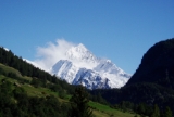
Piz Linard is a pyramid-shaped mountain
of the Swiss Alps
. At 3,410 m it is the highest peak of the Silvretta
mountain range.
It was first climbed on August 1, 1835 by the geologist
and naturalist
Oswald Heer
led by Johann Madutz.
There is a legend that a man of name "Chounard" reached the summit in 1572 carrying a large golden cross, however the cross has never been found.
Piz Linard is located between the valleys of Val Lavinuoz (east) and Val Saglains (west), both part of the basin of the Inn river
in the Engadin
e valley.
Mountain
Image:Himalaya_annotated.jpg|thumb|right|The Himalayan mountain range with Mount Everestrect 58 14 160 49 Chomo Lonzorect 200 28 335 52 Makalurect 378 24 566 45 Mount Everestrect 188 581 920 656 Tibetan Plateaurect 250 406 340 427 Rong River...
of the Swiss Alps
Swiss Alps
The Swiss Alps are the portion of the Alps mountain range that lies within Switzerland. Because of their central position within the entire Alpine range, they are also known as the Central Alps....
. At 3,410 m it is the highest peak of the Silvretta
Silvretta
The Silvretta Alps are a mountain range of the Central Eastern Alps shared by Tirol, Vorarlberg and Graubünden . The Austrian states of Tirol and Vorarlberg are connected by a pass road . The majority of the peaks are elevated above three thousand metres and are surrounded by glaciers...
mountain range.
It was first climbed on August 1, 1835 by the geologist
Geologist
A geologist is a scientist who studies the solid and liquid matter that constitutes the Earth as well as the processes and history that has shaped it. Geologists usually engage in studying geology. Geologists, studying more of an applied science than a theoretical one, must approach Geology using...
and naturalist
Natural history
Natural history is the scientific research of plants or animals, leaning more towards observational rather than experimental methods of study, and encompasses more research published in magazines than in academic journals. Grouped among the natural sciences, natural history is the systematic study...
Oswald Heer
Oswald Heer
Oswald Heer , Swiss geologist and naturalist, was born at Niederuzwil in Canton of St. Gallen and died in Lausanne.-Biography:...
led by Johann Madutz.
There is a legend that a man of name "Chounard" reached the summit in 1572 carrying a large golden cross, however the cross has never been found.
Piz Linard is located between the valleys of Val Lavinuoz (east) and Val Saglains (west), both part of the basin of the Inn river
Inn River
The Inn is a river in Switzerland, Austria and Germany. It is a right tributary of the Danube and is approximately 500km long. The highest point of its drainage basin is the summit of Piz Bernina, at 4,049 metres.- Geography :...
in the Engadin
Engadin
The Engadin or Engadine is a long valley in the Swiss Alps located in the canton of Graubünden in southeast Switzerland. It follows the route of the Inn River from its headwaters at Maloja Pass running northeast until the Inn flows into Austria one hundred kilometers downstream...
e valley.