

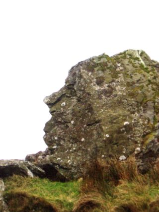
Pitt's Head
Encyclopedia
British national grid reference system
The Ordnance Survey National Grid reference system is a system of geographic grid references used in Great Britain, different from using latitude and longitude....
, close to the A4085 road
A4085 road
The A4085 is a 20-mile road between Caernarfon and Penrhyndeudraeth in North Wales that runs through the scenic Aberglaslyn Pass. There are several locations where the road is of substandard width....
in Gwynedd
Gwynedd
Gwynedd is a county in north-west Wales, named after the old Kingdom of Gwynedd. Although the second biggest in terms of geographical area, it is also one of the most sparsely populated...
, Wales
Wales
Wales is a country that is part of the United Kingdom and the island of Great Britain, bordered by England to its east and the Atlantic Ocean and Irish Sea to its west. It has a population of three million, and a total area of 20,779 km²...
. Its distinction lies in a resemblance to the profile of politician William Pitt the Younger
William Pitt the Younger
William Pitt the Younger was a British politician of the late 18th and early 19th centuries. He became the youngest Prime Minister in 1783 at the age of 24 . He left office in 1801, but was Prime Minister again from 1804 until his death in 1806...
.
Geography
Located as it is at the base of one of the paths to the summit of SnowdonSnowdon
Snowdon is the highest mountain in Wales, at an altitude of above sea level, and the highest point in the British Isles outside Scotland. It is located in Snowdonia National Park in Gwynedd, and has been described as "probably the busiest mountain in Britain"...
, Pitt’s Head was a halt on the original Welsh Highland Railway
Welsh Highland Railway
The Welsh Highland Railway is a long restored narrow gauge heritage railway in North Wales, operating from Caernarfon to Porthmadog, and passing through a number of popular tourist destinations including Beddgelert and the Aberglaslyn Pass. At Porthmadog it connects with the Ffestiniog Railway...
, also marking the highest point on that railway. The present reconstruction of the railway does not envisage reopening the halt. The rock also gives its name to the Pitt’s Head Bridge, where the railway passes under the A4085, and the nearby Pitt’s Head Cutting.
In the Geology
Geology
Geology is the science comprising the study of solid Earth, the rocks of which it is composed, and the processes by which it evolves. Geology gives insight into the history of the Earth, as it provides the primary evidence for plate tectonics, the evolutionary history of life, and past climates...
of the region, the rock gives its name to the rock of which it is formed, the Pitt’s Head Tuff. This is an Ordovician
Ordovician
The Ordovician is a geologic period and system, the second of six of the Paleozoic Era, and covers the time between 488.3±1.7 to 443.7±1.5 million years ago . It follows the Cambrian Period and is followed by the Silurian Period...
acid ash-flow tuff
Tuff
Tuff is a type of rock consisting of consolidated volcanic ash ejected from vents during a volcanic eruption. Tuff is sometimes called tufa, particularly when used as construction material, although tufa also refers to a quite different rock. Rock that contains greater than 50% tuff is considered...
which outcrop
Outcrop
An outcrop is a visible exposure of bedrock or ancient superficial deposits on the surface of the Earth. -Features:Outcrops do not cover the majority of the Earth's land surface because in most places the bedrock or superficial deposits are covered by a mantle of soil and vegetation and cannot be...
s on the northern flanks of Snowdonia
Snowdonia
Snowdonia is a region in north Wales and a national park of in area. It was the first to be designated of the three National Parks in Wales, in 1951.-Name and extent:...
.
Sources
- Leigh's guide to Wales & Monmouthshire, 1835, p. 71 Digitised
- Encyclopedia Britannica, 1911 Colwyn Bay Online Text.
However, this reference confuses irretrievably the town of Colwyn Bay
Colwyn Bay
- Demography :Prior to local government reorganisation on 1 April 1974 Colwyn Bay was a municipal borough with a population of c.25,000, but in 1974 this designation disappeared leaving five separate parishes, known as communities in Wales, of which the one bearing the name Colwyn Bay encompassed...
on the North Wales Coast, and the River Colwyn
River Colwyn
The River Colwyn is a small river in Gwynedd, north-west Wales, a tributary of the River Glaslyn....
which is close to Pitt's Head. There is no connection between the two apart from the name, but the Encyclopedia places Pitt's Head close to Colwyn Bay. It is nevertheless a source for the name of Pitt's Head.
- British Geological Survey, England and Wales Sheet 118
Further reading
- Magmatic Evolution of the Ordovician Snowdon Volcanic Centre, North Wales (UK) THORPE et al. J. Petrology. 1993; 34: 711-741
- see also references in Welsh Highland RailwayWelsh Highland RailwayThe Welsh Highland Railway is a long restored narrow gauge heritage railway in North Wales, operating from Caernarfon to Porthmadog, and passing through a number of popular tourist destinations including Beddgelert and the Aberglaslyn Pass. At Porthmadog it connects with the Ffestiniog Railway...