

Pim Island
Encyclopedia
Ellesmere Island
Ellesmere Island is part of the Qikiqtaaluk Region of the Canadian territory of Nunavut. Lying within the Canadian Arctic Archipelago, it is considered part of the Queen Elizabeth Islands, with Cape Columbia being the most northerly point of land in Canada...
, part of the Qikiqtaaluk Region of the Canadian
Canada
Canada is a North American country consisting of ten provinces and three territories. Located in the northern part of the continent, it extends from the Atlantic Ocean in the east to the Pacific Ocean in the west, and northward into the Arctic Ocean...
territory of Nunavut
Nunavut
Nunavut is the largest and newest federal territory of Canada; it was separated officially from the Northwest Territories on April 1, 1999, via the Nunavut Act and the Nunavut Land Claims Agreement Act, though the actual boundaries had been established in 1993...
. Located within the Canadian Arctic Archipelago
Canadian Arctic Archipelago
The Canadian Arctic Archipelago, also known as the Arctic Archipelago, is a Canadian archipelago north of the Canadian mainland in the Arctic...
, it is a part of the Queen Elizabeth Islands
Queen Elizabeth Islands
The Queen Elizabeth Islands are the northernmost cluster of islands in the Canadian Arctic Archipelago, split between Nunavut and Northwest Territories in Northern Canada.-Geography:...
.
Pim Island is separated from Ellesmere Island by Rice Strait
Rice Strait
Rice Strait is a narrow waterway between Ellesmere Island's eastern coast and Pim Island in northern Canada's territory of Nunavut. It connects Rosse Bay on the north with Buchanan Strait to the south.The strait is named after Sergeant George W...
, the waterway that connects Rosse Bay
Rosse Bay
Rosse Bay is an Arctic waterway in Qikiqtaaluk Region, Nunavut, Canada. It is located in Nares Strait between Pim Island and Ellesmere Island's Johan Peninsula. The bay is also connected to Rice Strait.-Geography:...
to the north and Buchanan Strait to the south. Nares Strait
Nares Strait
Nares Strait is a waterway between Ellesmere Island and Greenland that is the northern part of Baffin Bay where it meets the Lincoln Sea. From south to north, the strait includes Smith Sound, Kane Basin, Kennedy Channel, Hall Basin and Robeson Channel...
is to the east. Pim Island is 6 km. from Cocked Hat Island
Cocked Hat Island
Cocked Hat Island, located off the eastern coast of Ellesmere Island, is a part of the Qikiqtaaluk Region of the Canadian territory of Nunavut. The island is located within the Canadian Arctic Archipelago, and is a part of the Queen Elizabeth Islands....
.
History
The Adolphus GreelyAdolphus Greely
Adolphus Washington Greely , was an American Polar explorer, a United States Army officer and a recipient of the Medal of Honor.-Early military career:...
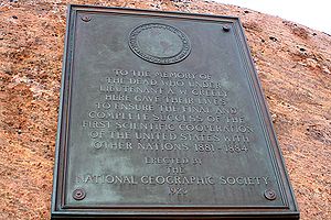
expedition wintered at Camp Clay in 1883, and in 1884, Cape Sabine
Cape Sabine
right|thumb|300px|Pim Island to the memory of dead men from the expedition of [[Adolphus Greely]]. Photographed in 2005Cape Sabine is a land point on Pim Island, in Qikiqtaaluk Region, Nunavut, Canada.-History:...
was the rescue site for Greely and the Lady Franklin Bay Expedition. The island is named in honor of naval officer and barrister Bedford Clapperton Trevelyan Pim
Bedford Clapperton Trevelyan Pim
Admiral Bedford Clapperton Trevelyan Pim, RN, MP, FRGS was a Royal Navy officer, Arctic explorer, barrister, and author...
of the HMS Resolute.