

Piercefield, New York
Encyclopedia
Piercefield is a town
in St. Lawrence County
, New York
, United States
. The population was 305 at the 2000 census.
The Town of Piercefield is in the southeast corner of the county and is southeast of Canton
.
Residents of the area included Abbot Augustus Low
who resided in an area known as Horseshoe.
, the town has a total area of 111.1 square miles (287.7 km²), of which, 104.3 square miles (270.1 km²) of it is land and 6.8 square miles (17.6 km²) of it (6.12%) is water.
 The east town line is the border of Franklin County
and the south town line is the border of Hamilton County
.
The town is within the Adirondack Park.
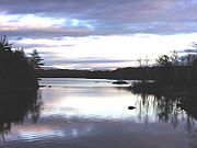
The Raquette River
flows through the town, and the southwest part of Tupper Lake
is inside the town.
New York State Route 3
is a highway connecting the north and south parts of th town. New York State Route 421
is a short highway in the southeast part of Piercefield.
of 2000, there were 305 people, 136 households, and 88 families residing in the town. The population density
was 2.9 people per square mile (1.1/km²). There were 417 housing units at an average density of 4.0 per square mile (1.5/km²). The racial makeup of the town was 97.70% White, 0.33% Native American, 0.66% Asian, 0.33% from other races
, and 0.98% from two or more races. Hispanic or Latino of any race were 0.98% of the population.
There were 136 households out of which 22.1% had children under the age of 18 living with them, 55.9% were married couples
living together, 5.9% had a female householder with no husband present, and 34.6% were non-families. 29.4% of all households were made up of individuals and 14.0% had someone living alone who was 65 years of age or older. The average household size was 2.24 and the average family size was 2.78.
In the town the population was spread out with 20.0% under the age of 18, 3.6% from 18 to 24, 25.2% from 25 to 44, 32.5% from 45 to 64, and 18.7% who were 65 years of age or older. The median age was 46 years. For every 100 females there were 103.3 males. For every 100 females age 18 and over, there were 100.0 males.
The median income for a household in the town was $34,643, and the median income for a family was $36,250. Males had a median income of $24,583 versus $27,083 for females. The per capita income
for the town was $16,635. About 7.8% of families and 8.3% of the population were below the poverty line, including 10.1% of those under the age of eighteen and 9.8% of those sixty five or over.
Town
A town is a human settlement larger than a village but smaller than a city. The size a settlement must be in order to be called a "town" varies considerably in different parts of the world, so that, for example, many American "small towns" seem to British people to be no more than villages, while...
in St. Lawrence County
St. Lawrence County, New York
St. Lawrence County is a county located in the U.S. state of New York. As of the 2010 census, the population was 111,944. The county seat is Canton. The county is named for the Saint Lawrence River, which in turn was named for the Catholic saint on whose Feast day the river was discovered by...
, New York
New York
New York is a state in the Northeastern region of the United States. It is the nation's third most populous state. New York is bordered by New Jersey and Pennsylvania to the south, and by Connecticut, Massachusetts and Vermont to the east...
, United States
United States
The United States of America is a federal constitutional republic comprising fifty states and a federal district...
. The population was 305 at the 2000 census.
The Town of Piercefield is in the southeast corner of the county and is southeast of Canton
Canton (village), New York
Canton is a village in St. Lawrence County, New York, United States. The village is centrally located in both the town of Canton and the county of St. Lawrence. The population was 5,882 at the 2000 census. It is the county seat of St. Lawrence County...
.
History
The town was established in 1801 before the creation of St. Lawrence County. The 1933 closing of the International Paper factory led to an economic downturn in the town.Residents of the area included Abbot Augustus Low
Abbot Augustus Low
Abbot Augustus Low was an entrepreneur and inventor from Brooklyn, who lived in St. Lawrence County, New York and was the owner of the Horseshoe Forestry Company...
who resided in an area known as Horseshoe.
Geography
According to the United States Census BureauUnited States Census Bureau
The United States Census Bureau is the government agency that is responsible for the United States Census. It also gathers other national demographic and economic data...
, the town has a total area of 111.1 square miles (287.7 km²), of which, 104.3 square miles (270.1 km²) of it is land and 6.8 square miles (17.6 km²) of it (6.12%) is water.
Franklin County, New York
Franklin County is a county located in the U.S. state of New York. As of the 2010 census, the population was 51,599. It is named in honor of American Founding Father Benjamin Franklin...
and the south town line is the border of Hamilton County
Hamilton County, New York
Hamilton County is a county located in the U.S. state of New York. It is named after Alexander Hamilton, the only member of the New York State delegation who signed the United States Constitution in 1787 and later the first United States Secretary of the Treasury. Its county seat is Lake Pleasant...
.
The town is within the Adirondack Park.
The Raquette River
Raquette River
The Raquette River, sometimes spelled Racquette, originates at Raquette Lake in the Adirondack Mountains in New York. long, it is the third longest river entirely in the state of New York....
flows through the town, and the southwest part of Tupper Lake
Tupper Lake (New York)
Tupper Lake is a lake in New York in the USA. The lake is in the Adirondack Park and crosses the county lines of St. Lawrence County and Franklin County....
is inside the town.
New York State Route 3
New York State Route 3
New York State Route 3 is a major east–west state highway in New York, United States, that connects central New York to the North Country region near the Canadian border via Adirondack Park. The route extends for between its western terminus at an intersection with NY 104A in the Cayuga...
is a highway connecting the north and south parts of th town. New York State Route 421
New York State Route 421
New York State Route 421 is a short state highway located within Adirondack Park in the southeastern corner of St. Lawrence County, New York, United States. It is a narrow, two-lane spur route connecting NY 30 to Horseshoe Lake by way of Tupper Lake. A dead end sign is posted immediately...
is a short highway in the southeast part of Piercefield.
Demographics
As of the censusCensus
A census is the procedure of systematically acquiring and recording information about the members of a given population. It is a regularly occurring and official count of a particular population. The term is used mostly in connection with national population and housing censuses; other common...
of 2000, there were 305 people, 136 households, and 88 families residing in the town. The population density
Population density
Population density is a measurement of population per unit area or unit volume. It is frequently applied to living organisms, and particularly to humans...
was 2.9 people per square mile (1.1/km²). There were 417 housing units at an average density of 4.0 per square mile (1.5/km²). The racial makeup of the town was 97.70% White, 0.33% Native American, 0.66% Asian, 0.33% from other races
Race (United States Census)
Race and ethnicity in the United States Census, as defined by the Federal Office of Management and Budget and the United States Census Bureau, are self-identification data items in which residents choose the race or races with which they most closely identify, and indicate whether or not they are...
, and 0.98% from two or more races. Hispanic or Latino of any race were 0.98% of the population.
There were 136 households out of which 22.1% had children under the age of 18 living with them, 55.9% were married couples
Marriage
Marriage is a social union or legal contract between people that creates kinship. It is an institution in which interpersonal relationships, usually intimate and sexual, are acknowledged in a variety of ways, depending on the culture or subculture in which it is found...
living together, 5.9% had a female householder with no husband present, and 34.6% were non-families. 29.4% of all households were made up of individuals and 14.0% had someone living alone who was 65 years of age or older. The average household size was 2.24 and the average family size was 2.78.
In the town the population was spread out with 20.0% under the age of 18, 3.6% from 18 to 24, 25.2% from 25 to 44, 32.5% from 45 to 64, and 18.7% who were 65 years of age or older. The median age was 46 years. For every 100 females there were 103.3 males. For every 100 females age 18 and over, there were 100.0 males.
The median income for a household in the town was $34,643, and the median income for a family was $36,250. Males had a median income of $24,583 versus $27,083 for females. The per capita income
Per capita income
Per capita income or income per person is a measure of mean income within an economic aggregate, such as a country or city. It is calculated by taking a measure of all sources of income in the aggregate and dividing it by the total population...
for the town was $16,635. About 7.8% of families and 8.3% of the population were below the poverty line, including 10.1% of those under the age of eighteen and 9.8% of those sixty five or over.
Communities and locations in Piercefield
- Catamount Pond – A lake adjacent to Gale.
- Childwold – A hamletHamlet (place)A hamlet is usually a rural settlement which is too small to be considered a village, though sometimes the word is used for a different sort of community. Historically, when a hamlet became large enough to justify building a church, it was then classified as a village...
northwest of Piercefield village on NY-3, near the west town line. - Childwood Station – A location south of Piercefield village.
- Conifer-- A hamlet southwest of Piercefield village.
- Eagle Crag Lake – A small lake west of the Mount Arab community.
- Gale – A hamlet on NY-3, northwest of Piercefield village.
- Horseshoe – A hamlet in the southwest part of the town, southwest of Mount Arab.
- Mount Arab – (1) A hamlet in the south part of the town, south of conifer, and (2) An elevation south of Piercefield village, famous for hiking.
- Mount Arab Lake – A small lake northwest of the Mount Arab community.
- Mount Arab Station – A location north of Mount Arab.
- Piercefield – The hamlet of Piercefield is on NY_3 by the Raquette River and Piercefield Flow near the center of the town.
- Piercefield Flow – A lake formed in a wide section of the Raquette River.
- Trout Pond – A lake by the south town line.