
Pfarrkirchen
Encyclopedia
Pfarrkirchen is a municipality
in southern Lower Bavaria
Germany, the capital of the district Rottal-Inn
. It has about 12,500 inhabitants and is an important school centre with about 10,000 pupils from all over Lower Bavaria. The town spreads over an area of about 52 square kilometers and lies approximately 377 meters above sea level. Pfarrkirchen lies at the small river "Rott", which gives the "Rottal" region its name.
The first settlers came to Pfarrkirchen some 7,000 years ago, as excavations in Untergaiching (a small suburb) prove. The first official written document where the name "Pharrachiricha" is mentioned, appeared in between 875 and 899 AD by the Catholic Bishop "Engilmar". The name means "parish church". In 1262 Pfarrkirchen and the nearby "Castle Reichenberg" passed into the possession of the Bavarian dynasty Wittelsbach
, who granted the village the right to hold public markets in 1317. Since 1862 Pfarrkirchen can officially call itself a town, and in 1972 it became the capital of the district Rottal-Inn
.
The town's best known landmark is the "Gartlbergkirche", a pilgrimage church for the Virgin Mary. It was built upon Pfarrkirchen's highest hill in between 1661 and 1715, according to the plans of the Italian architect Domenico Zuccali. The two towers of the Baroque Church dominate the town's scenery and can be seen even from miles away.
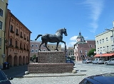
Another well known sight of Pfarrkirchen is the so-called "Wimmer-Roß", an oversized bronze statue, which is located at the heart of the town, showing a black stallion. It was built in 1966 by the sculptor Hans Wimmer, who donated the statue to his hometown. It symbolizes the high status of horse breeding in the Rottal region.
Pfarrkirchen also possesses Bavaria's oldest Harness Racing Track
, where horse races have been held since 1894.
One of Pfarrkirchen's important industries include abattoirs which is due to the rural environment.
Municipalities of Germany
Municipalities are the lowest level of territorial division in Germany. This may be the fourth level of territorial division in Germany, apart from those states which include Regierungsbezirke , where municipalities then become the fifth level.-Overview:With more than 3,400,000 inhabitants, the...
in southern Lower Bavaria
Lower Bavaria
Lower Bavaria is one of the seven administrative regions of Bavaria, Germany, located in the east of the state.- Geography :Lower Bavaria is subdivided into two regions - Landshut and Donau-Wald. Recent election results mark it as the most conservative part of Germany, generally giving huge...
Germany, the capital of the district Rottal-Inn
Rottal-Inn
Rottal-Inn is a Kreis in the southeastern part of Bavaria, Germany. Neighboring districts are Altötting, Mühldorf, Landshut, Dingolfing-Landau and Passau...
. It has about 12,500 inhabitants and is an important school centre with about 10,000 pupils from all over Lower Bavaria. The town spreads over an area of about 52 square kilometers and lies approximately 377 meters above sea level. Pfarrkirchen lies at the small river "Rott", which gives the "Rottal" region its name.
The first settlers came to Pfarrkirchen some 7,000 years ago, as excavations in Untergaiching (a small suburb) prove. The first official written document where the name "Pharrachiricha" is mentioned, appeared in between 875 and 899 AD by the Catholic Bishop "Engilmar". The name means "parish church". In 1262 Pfarrkirchen and the nearby "Castle Reichenberg" passed into the possession of the Bavarian dynasty Wittelsbach
Wittelsbach
The Wittelsbach family is a European royal family and a German dynasty from Bavaria.Members of the family served as Dukes, Electors and Kings of Bavaria , Counts Palatine of the Rhine , Margraves of Brandenburg , Counts of Holland, Hainaut and Zeeland , Elector-Archbishops of Cologne , Dukes of...
, who granted the village the right to hold public markets in 1317. Since 1862 Pfarrkirchen can officially call itself a town, and in 1972 it became the capital of the district Rottal-Inn
Rottal-Inn
Rottal-Inn is a Kreis in the southeastern part of Bavaria, Germany. Neighboring districts are Altötting, Mühldorf, Landshut, Dingolfing-Landau and Passau...
.
The town's best known landmark is the "Gartlbergkirche", a pilgrimage church for the Virgin Mary. It was built upon Pfarrkirchen's highest hill in between 1661 and 1715, according to the plans of the Italian architect Domenico Zuccali. The two towers of the Baroque Church dominate the town's scenery and can be seen even from miles away.
Another well known sight of Pfarrkirchen is the so-called "Wimmer-Roß", an oversized bronze statue, which is located at the heart of the town, showing a black stallion. It was built in 1966 by the sculptor Hans Wimmer, who donated the statue to his hometown. It symbolizes the high status of horse breeding in the Rottal region.
Pfarrkirchen also possesses Bavaria's oldest Harness Racing Track
Harness racing
Harness racing is a form of horse racing in which the horses race at a specific gait . They usually pull a two-wheeled cart called a sulky, although racing under saddle is also conducted in Europe.-Breeds:...
, where horse races have been held since 1894.
One of Pfarrkirchen's important industries include abattoirs which is due to the rural environment.
Twin Cities
- Since 1991 Pfarrkirchen is twinned with the town of St. Rémy de Provence in southern FranceFranceThe French Republic , The French Republic , The French Republic , (commonly known as France , is a unitary semi-presidential republic in Western Europe with several overseas territories and islands located on other continents and in the Indian, Pacific, and Atlantic oceans. Metropolitan France...
- Since 1997 Pfarrkirchen is twinned with the region Luzerner Rottal comprising the towns RuswilRuswilRuswil is a municipality in the district of Sursee in the canton of Lucerne in Switzerland.-Geography:Ruswil has an area of . Of this area, 72.7% is used for agricultural purposes, while 20.9% is forested. Of the rest of the land, 6.2% is settled and the remainder is non-productive...
, Ettswil, ButtisholzButtisholzButtisholz is a municipality in the district of Sursee in the canton of Lucerne in Switzerland.-Geography:Buttisholz has an area of . Of this area, 73.7% is used for agricultural purposes, while 17% is forested. Of the rest of the land, 7.5% is settled and the remainder is non-productive...
, and GrosswangenGrosswangenGrosswangen is a municipality in the district of Sursee in the canton of Lucerne in Switzerland.-Geography:Grosswangen has an area of . Of this area, 78.3% is used for agricultural purposes, while 15.3% is forested. Of the rest of the land, 5.9% is settled and the remainder is non-productive...
in SwitzerlandSwitzerlandSwitzerland name of one of the Swiss cantons. ; ; ; or ), in its full name the Swiss Confederation , is a federal republic consisting of 26 cantons, with Bern as the seat of the federal authorities. The country is situated in Western Europe,Or Central Europe depending on the definition.... - Since 1998 Pfarrkirchen is twinned with the town of San Vincenzo in the region Toscana in ItalyItalyItaly , officially the Italian Republic languages]] under the European Charter for Regional or Minority Languages. In each of these, Italy's official name is as follows:;;;;;;;;), is a unitary parliamentary republic in South-Central Europe. To the north it borders France, Switzerland, Austria and...
.