
Perlethorpe
Encyclopedia
Perlethorpe is a small village
in Nottinghamshire
. It is located 3 miles north-west of Ollerton
, and is in the civil parish
of Perlethorpe-cum-Budby. According to the 2001 census
the parish had a population of 198. Nearby is Thoresby Hall
, the former home of the Earl Manvers
.
, and nearby Lincolnshire
. The first element of the name, perle is unknown, and toponymist
s can only speculate as to its origin. However there are three particularly popular suggestions. The first is "rush of water" from the Old English and Middle English
perle. The second is that it's a deviation from the possible original name Palethorpe, pale meaning "area enclosed by a boundary". Lastly it may have been a deviation from Peverelthorpe as William Peverel was a powerful landowner in the area during the reign of Henry II
.
 The village itself is located about a quarter of a mile west of the A614
, about half a mile north of Ollerton
and 10 miles north east of Mansfield
. The River Meden
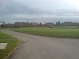
runs nearby. The village contains a large green
, a village hall, a large church (of St John the Evangelist) and a village shop. There was once a primary school in the village but that has since been closed down and the building used as an Environmental Education Centre to teach children from many schools about the countryside.
Although the village has a much longer history, the oldest buildings which now remain date back only as far as the middle of the 19th century. The church of St John was built in 1876 and became the parish church
in 1877. The half-timbered Almshouses near the church were built c. 1890. Perhaps the most striking buildings are the "Redbrick" buildings, dating from the 1950s which are found clustered around the village green. These, like many of the older dwellings, were used exclusively for workers at Thoresby Hall
when they were first built. Roman coins were found in the village in the 2000s. The parish records date from 1529, some 10 years before it became law for them to be kept, making them some of the oldest in the country.
Village
A village is a clustered human settlement or community, larger than a hamlet with the population ranging from a few hundred to a few thousand , Though often located in rural areas, the term urban village is also applied to certain urban neighbourhoods, such as the West Village in Manhattan, New...
in Nottinghamshire
Nottinghamshire
Nottinghamshire is a county in the East Midlands of England, bordering South Yorkshire to the north-west, Lincolnshire to the east, Leicestershire to the south, and Derbyshire to the west...
. It is located 3 miles north-west of Ollerton
Ollerton
Ollerton is a town in Nottinghamshire, England, on the edge of Sherwood Forest in the area known as the Dukeries. It forms part of the civil parish of Ollerton and Boughton....
, and is in the civil parish
Civil parish
In England, a civil parish is a territorial designation and, where they are found, the lowest tier of local government below districts and counties...
of Perlethorpe-cum-Budby. According to the 2001 census
United Kingdom Census 2001
A nationwide census, known as Census 2001, was conducted in the United Kingdom on Sunday, 29 April 2001. This was the 20th UK Census and recorded a resident population of 58,789,194....
the parish had a population of 198. Nearby is Thoresby Hall
Thoresby Hall
Thoresby Hall is one of the Dukeries, four country houses and estates in north Nottinghamshire all occupied by dukes at one time in their history.-History:...
, the former home of the Earl Manvers
Earl Manvers
Earl Manvers was a title in the Peerage of the United Kingdom. It was created in 1806 for Charles Pierrepont, 1st Viscount Newark. He had already been created Baron Pierrepont, of Holme Pierrepont in the County of Nottingham, and Viscount Newark, of Newark-on-Trent in the County of Nottingham, in...
.
Etymology
Perlethorpe is from Old Norse thorp/þrop "village", a place-name element common in NottinghamshireNottinghamshire
Nottinghamshire is a county in the East Midlands of England, bordering South Yorkshire to the north-west, Lincolnshire to the east, Leicestershire to the south, and Derbyshire to the west...
, and nearby Lincolnshire
Lincolnshire
Lincolnshire is a county in the east of England. It borders Norfolk to the south east, Cambridgeshire to the south, Rutland to the south west, Leicestershire and Nottinghamshire to the west, South Yorkshire to the north west, and the East Riding of Yorkshire to the north. It also borders...
. The first element of the name, perle is unknown, and toponymist
Toponymy
Toponymy is the scientific study of place names , their origins, meanings, use and typology. The word "toponymy" is derived from the Greek words tópos and ónoma . Toponymy is itself a branch of onomastics, the study of names of all kinds...
s can only speculate as to its origin. However there are three particularly popular suggestions. The first is "rush of water" from the Old English and Middle English
Middle English
Middle English is the stage in the history of the English language during the High and Late Middle Ages, or roughly during the four centuries between the late 11th and the late 15th century....
perle. The second is that it's a deviation from the possible original name Palethorpe, pale meaning "area enclosed by a boundary". Lastly it may have been a deviation from Peverelthorpe as William Peverel was a powerful landowner in the area during the reign of Henry II
Henry II of England
Henry II ruled as King of England , Count of Anjou, Count of Maine, Duke of Normandy, Duke of Aquitaine, Duke of Gascony, Count of Nantes, Lord of Ireland and, at various times, controlled parts of Wales, Scotland and western France. Henry, the great-grandson of William the Conqueror, was the...
.
Geography and History
A614 road
The A614 is a main road in England running through the counties of Nottinghamshire, South Yorkshire and the East Riding of Yorkshire.Beginning at Redhill, near Calverton in Nottinghamshire at a roundabout with the A60, the road meets the A6097 at a junction which looks like a roundabout but...
, about half a mile north of Ollerton
Ollerton
Ollerton is a town in Nottinghamshire, England, on the edge of Sherwood Forest in the area known as the Dukeries. It forms part of the civil parish of Ollerton and Boughton....
and 10 miles north east of Mansfield
Mansfield
Mansfield is a town in Nottinghamshire, England. It is the main town in the Mansfield local government district. Mansfield is a part of the Mansfield Urban Area....
. The River Meden
River Meden
The River Meden is a river in Nottinghamshire, England. Its source lies just north of Huthwaite, near the Derbyshire border, and from there it flows north east through Pleasley and Warsop before merging temporarily with the River Maun near Bothamsall...
runs nearby. The village contains a large green
Village green
A village green is a common open area which is a part of a settlement. Traditionally, such an area was often common grass land at the centre of a small agricultural settlement, used for grazing and sometimes for community events...
, a village hall, a large church (of St John the Evangelist) and a village shop. There was once a primary school in the village but that has since been closed down and the building used as an Environmental Education Centre to teach children from many schools about the countryside.
Although the village has a much longer history, the oldest buildings which now remain date back only as far as the middle of the 19th century. The church of St John was built in 1876 and became the parish church
Parish church
A parish church , in Christianity, is the church which acts as the religious centre of a parish, the basic administrative unit of episcopal churches....
in 1877. The half-timbered Almshouses near the church were built c. 1890. Perhaps the most striking buildings are the "Redbrick" buildings, dating from the 1950s which are found clustered around the village green. These, like many of the older dwellings, were used exclusively for workers at Thoresby Hall
Thoresby Hall
Thoresby Hall is one of the Dukeries, four country houses and estates in north Nottinghamshire all occupied by dukes at one time in their history.-History:...
when they were first built. Roman coins were found in the village in the 2000s. The parish records date from 1529, some 10 years before it became law for them to be kept, making them some of the oldest in the country.