
Pennsylvania Route 858
Encyclopedia
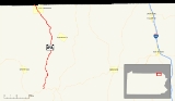
Pennsylvania Route 858 is a 16.58 miles (26.7 km) long state highway
located in Susquehanna
County in Pennsylvania
. The southern terminus is at PA 706
in Rush Township
. The northern terminus is the New York
state line in Little Meadows
. The route from there continues as Tioga County Highway 601. The route was assigned in 1928, completed a year later, and has remained the same since, with an exception of its southern terminus changing designations from Pennsylvania Route 67.
in the Rush Township community of Rushville. The highway begins its long trek in Susquehanna County by progressing northward in a patch of forests. Route 858, which runs west of a creek, is sparsely populated and homes are rare. State Route 858 winds its way in and out of forests, heading on a northeast direction. Soon after, there is an intersection with Keefs Hill Road, a locally-maintained highway. After Keefs Hill Road, State Route 858 heads back into a dense patch of trees. In the forest, is an intersection with C. Warner Road, and soon after comes one for Shadduck Road.
Although the dense forest ends, trees continue to surround the highway. The route turns a short drift off its alignment at an intersection with Miller Road. The route turns from the northward direction it was heading to a northwestern direction and intersects eventually with Guilton Road. The dense forestry returns, and Route 858 begins winding its way along. Residential homes have all but disappeared from the route, with trees showing the way into Middletown Center. State Route 858 passes a pond to the east, intersecting with the former alignment of State Route 859, now a locally-maintained highway known as Vet Davis Road and Camp Corby Road.
After leaving Middletown Center, State Route 858 continues northward and sometimes northeastward. After Middletown Center, Route 858 is surrounded by nothing but trees. There is a break in the trees when State Route 858 intersects with an unnamed road, which serves as a connector to Township Road 768. The state traffic route continues to the northwest, intersecting with Township Road 687. As State Route 858 continues, it enters Apolacon Township
, where the dense forestry begins to break, and homes begin to show the way. After a short pond is passed, the highway enters Little Meadows
. At Maple Avenue, Route 858 runs on its final stretch, passing homes all the way to the New York state line. There, State Route 858 ends and becomes County Route 41 upon entering Tioga County, New York
.
. Instead, it was an intersection with State Route 67. When it was assigned, it only ran from U.S. Route 106 to Town House Road, since the rest had not been completed yet. The final, already paved segment of SR 858 was completed by the next year. In 1932, the route south of Town House Road was paved. In 1972, State Route 67 was decommissioned, and the route at the southern terminus became State Route 706.
State highway
State highway, state road or state route can refer to one of three related concepts, two of them related to a state or provincial government in a country that is divided into states or provinces :#A...
located in Susquehanna
Susquehanna County, Pennsylvania
-Demographics:As of the census of 2000, there were 42,238 people, 16,529 households, and 11,785 families residing in the county. The population density was 51 people per square mile . There were 21,829 housing units at an average density of 26 per square mile...
County in Pennsylvania
Pennsylvania
The Commonwealth of Pennsylvania is a U.S. state that is located in the Northeastern and Mid-Atlantic regions of the United States. The state borders Delaware and Maryland to the south, West Virginia to the southwest, Ohio to the west, New York and Ontario, Canada, to the north, and New Jersey to...
. The southern terminus is at PA 706
Pennsylvania Route 706
Pennsylvania Route 706 is a long state highway in Pennsylvania. The western terminus is at U.S. Route 6 in Wyalusing, and the eastern terminus is at U.S. Route 11 in Milford.- Major intersections :- History :...
in Rush Township
Rush Township, Susquehanna County, Pennsylvania
Rush Township is a township in Susquehanna County, Pennsylvania, United States. The population was 1,290 at the 2000 census.-Geography:According to the United States Census Bureau, the township has a total area of 37.9 square miles , of which, 37.8 square miles of it is land and...
. The northern terminus is the New York
New York
New York is a state in the Northeastern region of the United States. It is the nation's third most populous state. New York is bordered by New Jersey and Pennsylvania to the south, and by Connecticut, Massachusetts and Vermont to the east...
state line in Little Meadows
Little Meadows, Pennsylvania
Little Meadows is a borough in Susquehanna County, Pennsylvania, United States. The population was 290 at the 2000 census.-Geography:Little Meadows is located at ....
. The route from there continues as Tioga County Highway 601. The route was assigned in 1928, completed a year later, and has remained the same since, with an exception of its southern terminus changing designations from Pennsylvania Route 67.
Route description
State Route 858 begins at an intersection with State Route 706Pennsylvania Route 706
Pennsylvania Route 706 is a long state highway in Pennsylvania. The western terminus is at U.S. Route 6 in Wyalusing, and the eastern terminus is at U.S. Route 11 in Milford.- Major intersections :- History :...
in the Rush Township community of Rushville. The highway begins its long trek in Susquehanna County by progressing northward in a patch of forests. Route 858, which runs west of a creek, is sparsely populated and homes are rare. State Route 858 winds its way in and out of forests, heading on a northeast direction. Soon after, there is an intersection with Keefs Hill Road, a locally-maintained highway. After Keefs Hill Road, State Route 858 heads back into a dense patch of trees. In the forest, is an intersection with C. Warner Road, and soon after comes one for Shadduck Road.
Although the dense forest ends, trees continue to surround the highway. The route turns a short drift off its alignment at an intersection with Miller Road. The route turns from the northward direction it was heading to a northwestern direction and intersects eventually with Guilton Road. The dense forestry returns, and Route 858 begins winding its way along. Residential homes have all but disappeared from the route, with trees showing the way into Middletown Center. State Route 858 passes a pond to the east, intersecting with the former alignment of State Route 859, now a locally-maintained highway known as Vet Davis Road and Camp Corby Road.
After leaving Middletown Center, State Route 858 continues northward and sometimes northeastward. After Middletown Center, Route 858 is surrounded by nothing but trees. There is a break in the trees when State Route 858 intersects with an unnamed road, which serves as a connector to Township Road 768. The state traffic route continues to the northwest, intersecting with Township Road 687. As State Route 858 continues, it enters Apolacon Township
Apolacon Township, Pennsylvania
Apolacon Township is a township in Susquehanna County, Pennsylvania, United States. The population was 507 at the 2000 census.-Geography:According to the United States Census Bureau, the township has a total area of , of which, of it is land and of it is water.-Demographics:As of the census of...
, where the dense forestry begins to break, and homes begin to show the way. After a short pond is passed, the highway enters Little Meadows
Little Meadows, Pennsylvania
Little Meadows is a borough in Susquehanna County, Pennsylvania, United States. The population was 290 at the 2000 census.-Geography:Little Meadows is located at ....
. At Maple Avenue, Route 858 runs on its final stretch, passing homes all the way to the New York state line. There, State Route 858 ends and becomes County Route 41 upon entering Tioga County, New York
Tioga County, New York
As of the census of 2010, there were 51,125 people residing in the county, with 22,203 housing units, of these 20,350 occupied, 1,853 vacant. The population density was 98 people per square mile...
.
History
State Route 858 was first assigned in the mass numbering of state traffic routes in Pennsylvania in 1928. However, the southern terminus of the highway was not an intersection with Pennsylvania Route 706Pennsylvania Route 706
Pennsylvania Route 706 is a long state highway in Pennsylvania. The western terminus is at U.S. Route 6 in Wyalusing, and the eastern terminus is at U.S. Route 11 in Milford.- Major intersections :- History :...
. Instead, it was an intersection with State Route 67. When it was assigned, it only ran from U.S. Route 106 to Town House Road, since the rest had not been completed yet. The final, already paved segment of SR 858 was completed by the next year. In 1932, the route south of Town House Road was paved. In 1972, State Route 67 was decommissioned, and the route at the southern terminus became State Route 706.