
Pennsylvania Route 663
Encyclopedia
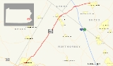
Pennsylvania Route 663 is a 22.98 miles (37 km) long state highway
in Bucks
and Montgomery
counties in southeast Pennsylvania
. Its northern terminus is at PA 309
and PA 313
in Quakertown
, where it continues eastward as PA 313, and its southern terminus is at PA 100
in Pottstown
. Along the way, PA 663 also passes through the town of Pennsburg
. It is called John Fries Highway between Pennsburg and Quakertown. It has its own interchange with the Northeast Extension
of the Pennsylvania Turnpike
at exit 44 west of Quakertown. The route was assigned in 1930, and it has had several realignments since its commissioning, including two major ones.
 PA 663 begins at an intersection on PA 100
in Pottstown
. The route progresses eastward, passing to the south of Memorial Park and crossing over the Manatawny River. At Manatawny Street, PA 663 goes from the moniker of West King Street to King Street and continues as a borough street. The highway passes north of the Pottstown Borough Hall and turns onto North Charlotte Street soon after. The route turns to the northeast, passing Pottstown Cemetery's eastern segment. The highway continues through the rest of the town as North Charlotte Street. As PA 663 begins to leave Pottstown, the surroundings become less populated. Just north of the borough line, Orlando Road, which split off in Pottstown, merges back in. About a mile north, PA 663 intersects with a road that connects to a housing complex.
Just farther up the road, there is another housing complex, which connects to Buchert Road. North of the housing complexes, the road becomes less populated, with homes and fields surrounding the highway. PA 663 intersects with the Swamp Pike soon after. The route continues into the lowlands of Montgomery County
, where it retains the North Charlotte Street moniker. However, the name changes as soon as the highway becomes concurrent with PA 73
(Big Road). During the concurrency, PA 663 and PA 73 cross a river (as Big Road) and split. No longer on PA 73, PA 663 continues to the northeast, using the street moniker of Layfield Road. The population that had surrounded the highway south of PA 73 is gone, and the route heads northeastward, where it passes several fields. There is a small bounce in population when PA 663 enters Hoffmansville. However, PA 663 leaves Hoffmansville and continues back into the rural area.
. The highway heads through some light forest and enters the municipality of Pleasant Run soon after. The route leaves quickly for Halegrass, a more populated municipality, and some homes are found along the highway. PA 663 continues northward, using Layfield Road into Green Lane Reservoir Park. The route then crosses the reservoir soon after on two causeways (each with a small bridge) and a hilly island between them, where PA 663 crosses Kutztown Rd. While following the reservoir, PA 663 passes some homes. To the west, there is an intersection with Montgomery Avenue, which connects to a housing complex. The route, however, continues into Pennsburg
, where the highway becomes populated once again.
 SR 663 continues into Pennsburg, intersecting with PA 29
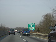
. However, not far after the intersection with PA 29, PA 663 leaves Pennsburg and gains the John Fries Highway moniker. The route continues northeastward, passing the Holy Cross Cemetery. The population that once surrounded the highway is now gone, and the route continues steadily eastward, intersecting with Geryville Pike. North of Geryville Pike, there is a small stretch where signs of an aborted widening project can be found, including rock cuts and guard rails that are rather far from the right-of-way. The route progresses into Mumbauersville, and continues to the northeast. PA 663 continues into Milford Township, where it interchanges with Interstate 476
(I-476), or the Pennsylvania Turnpike
's Northeastern Extension. A park and ride
is to the south of the interchange ramps, and the route continues eastward (although the highway is signed as north/south) into farther parts of Milford Township
.
The route leaves Milford Township after passing through Milford Square, a small village in the township. To the south of PA 663 are buildings and to the north are fields and trees. The highway enters Quakertown
, and the area becomes more populated once again. After the intersection with Old Bethlehem Pike, PA 663 terminates at an intersection with PA 309
and PA 313
.
State highway
State highway, state road or state route can refer to one of three related concepts, two of them related to a state or provincial government in a country that is divided into states or provinces :#A...
in Bucks
Bucks County, Pennsylvania
- Industry and commerce :The boroughs of Bristol and Morrisville were prominent industrial centers along the Northeast Corridor during World War II. Suburban development accelerated in Lower Bucks in the 1950s with the opening of Levittown, Pennsylvania, the second such "Levittown" designed by...
and Montgomery
Montgomery County, Pennsylvania
Montgomery County is a county located in the U.S. state of Pennsylvania, in the United States. As of 2010, the population was 799,874, making it the third most populous county in Pennsylvania . The county seat is Norristown.The county was created on September 10, 1784, out of land originally part...
counties in southeast Pennsylvania
Pennsylvania
The Commonwealth of Pennsylvania is a U.S. state that is located in the Northeastern and Mid-Atlantic regions of the United States. The state borders Delaware and Maryland to the south, West Virginia to the southwest, Ohio to the west, New York and Ontario, Canada, to the north, and New Jersey to...
. Its northern terminus is at PA 309
Pennsylvania Route 309
Pennsylvania Route 309 is a major highway which runs for 134 miles through Pennsylvania in the United States. It connects Philadelphia and its northern suburbs to Allentown, Hazleton, and Wilkes-Barre. A limited-access highway portion of PA 309 in the Wilkes-Barre area is known as the North...
and PA 313
Pennsylvania Route 313
Pennsylvania Route 313 is a mostly 2-lane, long state highway entirely within Bucks County, Pennsylvania. It is an east–west road, although it runs almost purely northwest/southeast through most of its course...
in Quakertown
Quakertown, Pennsylvania
Quakertown is a borough in Bucks County, Pennsylvania, in the United States. As of the 2010 census, it had a population of 8,979. The borough is south of Bethlehem and north of Philadelphia, making Quakertown a border town of both the Delaware Valley and Lehigh Valley metropolitan areas...
, where it continues eastward as PA 313, and its southern terminus is at PA 100
Pennsylvania Route 100
Pennsylvania Route 100 is a state highway in the U.S. state of Pennsylvania that runs from U.S. Route 202 in West Chester, Pennsylvania to Pennsylvania Route 309 in Pleasant Corners, Pennsylvania....
in Pottstown
Pottstown, Pennsylvania
Pottstown is a borough in Montgomery County, Pennsylvania, United States northwest of Philadelphia and southeast of Reading, on the Schuylkill River. Pottstown was laid out in 1752–53 and named Pottsgrove in honor of its founder, John Potts. The old name was abandoned at the time of the...
. Along the way, PA 663 also passes through the town of Pennsburg
Pennsburg, Pennsylvania
Pennsburg is a borough in Montgomery County, Pennsylvania, United States. The population was 3,843 at the 2010 census.It is part of the Upper Perkiomen School District....
. It is called John Fries Highway between Pennsburg and Quakertown. It has its own interchange with the Northeast Extension
Interstate 476
Interstate 476 is a auxiliary Interstate Highway in the U.S. state of Pennsylvania designated between Interstate 95 near Chester and Interstate 81 near Scranton, serving as the primary north–south Interstate corridor through eastern Pennsylvania....
of the Pennsylvania Turnpike
Pennsylvania Turnpike
The Pennsylvania Turnpike is a toll highway system operated by the Pennsylvania Turnpike Commission in the Commonwealth of Pennsylvania, United States. The three sections of the turnpike system total . The main section extends from Ohio to New Jersey and is long...
at exit 44 west of Quakertown. The route was assigned in 1930, and it has had several realignments since its commissioning, including two major ones.
Pottstown to Hoffmansville
Pennsylvania Route 100
Pennsylvania Route 100 is a state highway in the U.S. state of Pennsylvania that runs from U.S. Route 202 in West Chester, Pennsylvania to Pennsylvania Route 309 in Pleasant Corners, Pennsylvania....
in Pottstown
Pottstown, Pennsylvania
Pottstown is a borough in Montgomery County, Pennsylvania, United States northwest of Philadelphia and southeast of Reading, on the Schuylkill River. Pottstown was laid out in 1752–53 and named Pottsgrove in honor of its founder, John Potts. The old name was abandoned at the time of the...
. The route progresses eastward, passing to the south of Memorial Park and crossing over the Manatawny River. At Manatawny Street, PA 663 goes from the moniker of West King Street to King Street and continues as a borough street. The highway passes north of the Pottstown Borough Hall and turns onto North Charlotte Street soon after. The route turns to the northeast, passing Pottstown Cemetery's eastern segment. The highway continues through the rest of the town as North Charlotte Street. As PA 663 begins to leave Pottstown, the surroundings become less populated. Just north of the borough line, Orlando Road, which split off in Pottstown, merges back in. About a mile north, PA 663 intersects with a road that connects to a housing complex.
Just farther up the road, there is another housing complex, which connects to Buchert Road. North of the housing complexes, the road becomes less populated, with homes and fields surrounding the highway. PA 663 intersects with the Swamp Pike soon after. The route continues into the lowlands of Montgomery County
Montgomery County, Pennsylvania
Montgomery County is a county located in the U.S. state of Pennsylvania, in the United States. As of 2010, the population was 799,874, making it the third most populous county in Pennsylvania . The county seat is Norristown.The county was created on September 10, 1784, out of land originally part...
, where it retains the North Charlotte Street moniker. However, the name changes as soon as the highway becomes concurrent with PA 73
Pennsylvania Route 73
Pennsylvania Route 73 is a 62.51 miles long east–west state highway in southeastern Pennsylvania. It runs from Pennsylvania Route 61 in Leesport to the New Jersey state line on the Tacony-Palmyra Bridge in Philadelphia, where it continues as New Jersey Route 73.Predating the Interstate...
(Big Road). During the concurrency, PA 663 and PA 73 cross a river (as Big Road) and split. No longer on PA 73, PA 663 continues to the northeast, using the street moniker of Layfield Road. The population that had surrounded the highway south of PA 73 is gone, and the route heads northeastward, where it passes several fields. There is a small bounce in population when PA 663 enters Hoffmansville. However, PA 663 leaves Hoffmansville and continues back into the rural area.
Hoffmansville to Quakertown
Continuing to the northeast, PA 663 intersects with Schultz Road, which is a connector to Pleasant Run Park, a local park in New Hanover TownshipNew Hanover Township, Pennsylvania
New Hanover Township is a township in Montgomery County, Pennsylvania, United States. The population was 10,939 at the 2010 census.-Geography:...
. The highway heads through some light forest and enters the municipality of Pleasant Run soon after. The route leaves quickly for Halegrass, a more populated municipality, and some homes are found along the highway. PA 663 continues northward, using Layfield Road into Green Lane Reservoir Park. The route then crosses the reservoir soon after on two causeways (each with a small bridge) and a hilly island between them, where PA 663 crosses Kutztown Rd. While following the reservoir, PA 663 passes some homes. To the west, there is an intersection with Montgomery Avenue, which connects to a housing complex. The route, however, continues into Pennsburg
Pennsburg, Pennsylvania
Pennsburg is a borough in Montgomery County, Pennsylvania, United States. The population was 3,843 at the 2010 census.It is part of the Upper Perkiomen School District....
, where the highway becomes populated once again.
Pennsylvania Route 29
Pennsylvania Route 29 is a 118 mile long north–south state highway that runs through most of eastern Pennsylvania. The route currently exists in two segments, a southern segment and a northern segment. The southernmost terminus of the designation is at U.S. Route 30 in Malvern...
. However, not far after the intersection with PA 29, PA 663 leaves Pennsburg and gains the John Fries Highway moniker. The route continues northeastward, passing the Holy Cross Cemetery. The population that once surrounded the highway is now gone, and the route continues steadily eastward, intersecting with Geryville Pike. North of Geryville Pike, there is a small stretch where signs of an aborted widening project can be found, including rock cuts and guard rails that are rather far from the right-of-way. The route progresses into Mumbauersville, and continues to the northeast. PA 663 continues into Milford Township, where it interchanges with Interstate 476
Interstate 476
Interstate 476 is a auxiliary Interstate Highway in the U.S. state of Pennsylvania designated between Interstate 95 near Chester and Interstate 81 near Scranton, serving as the primary north–south Interstate corridor through eastern Pennsylvania....
(I-476), or the Pennsylvania Turnpike
Pennsylvania Turnpike
The Pennsylvania Turnpike is a toll highway system operated by the Pennsylvania Turnpike Commission in the Commonwealth of Pennsylvania, United States. The three sections of the turnpike system total . The main section extends from Ohio to New Jersey and is long...
's Northeastern Extension. A park and ride
Park and ride
Park and ride facilities are car parks with connections to public transport that allow commuters and other people wishing to travel into city centres to leave their vehicles and transfer to a bus, rail system , or carpool for the rest of their trip...
is to the south of the interchange ramps, and the route continues eastward (although the highway is signed as north/south) into farther parts of Milford Township
Milford Township, Bucks County, Pennsylvania
Milford Township is a township in Bucks County, Pennsylvania, United States. The population was 9,902 at the 2010 census. It is home to the Quakertown interchange of the Northeast Extension of the Pennsylvania Turnpike.-Geography:...
.
The route leaves Milford Township after passing through Milford Square, a small village in the township. To the south of PA 663 are buildings and to the north are fields and trees. The highway enters Quakertown
Quakertown, Pennsylvania
Quakertown is a borough in Bucks County, Pennsylvania, in the United States. As of the 2010 census, it had a population of 8,979. The borough is south of Bethlehem and north of Philadelphia, making Quakertown a border town of both the Delaware Valley and Lehigh Valley metropolitan areas...
, and the area becomes more populated once again. After the intersection with Old Bethlehem Pike, PA 663 terminates at an intersection with PA 309
Pennsylvania Route 309
Pennsylvania Route 309 is a major highway which runs for 134 miles through Pennsylvania in the United States. It connects Philadelphia and its northern suburbs to Allentown, Hazleton, and Wilkes-Barre. A limited-access highway portion of PA 309 in the Wilkes-Barre area is known as the North...
and PA 313
Pennsylvania Route 313
Pennsylvania Route 313 is a mostly 2-lane, long state highway entirely within Bucks County, Pennsylvania. It is an east–west road, although it runs almost purely northwest/southeast through most of its course...
.