
Pemadumcook Chain of Lakes
Encyclopedia
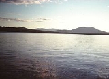
The Pemadumcook Chain of Lakes are a set of large lakes in north-central Maine
in the United States
.
. If one takes a landscape picture from that summit, these lakes span the distance from the Piscataquis Mountains in the west to North Twin dam on Elbow Lake in the east. It is the fifth-largest lake system in Maine, exceeded only by Moosehead Lake
at 74890 acres (303 km²), Sebago Lake
at 28771 acres (116 km²), Chesuncook Lake
at 23070 acres (93 km²), and Flagstaff Lake
at 20300 acres (82.2 km²). The Pemadumcook Chain of Lakes occupy 18300 acres (74.1 km²). Individually Mooselookmeguntic Lake
is larger than Pemadumcook, but it is not larger than the chain.
The series of lakes are named Ambajejus, Elbow, North Twin, Pemadumcook and South Twin Lake
. The lakes are part of the West Branch
of the Penobscot River
. The West Branch enters the northwest corner of Ambajejus, and the current flows south through that lake. The channel passes Deep Cove on the east and Porus Isands to the west. The river channel then passes east through the east end of Pemadumcook into the head of North Twin Lake at Indian Point. The channel then follows a southeasterly course across North Twin Lake, staying between Perrow Point and Spring Island, and then veering eastward past Snake Point in sight of the settlement of Norcross. The channel then passes due east through the Elbow to North Twin dam. The length of the channel is about 11.5 miles (18.5 km). The combined length of the lake from the North Twin Dam, following the channel in reverse to the Porus Islands and thence to the northwest corner of Pemadumcook at Nahmakanta Stream, is nearly 14 miles (23 km). There is a large boulder in Nahmakanta Stream where the Appalachian Trail
appears on the south bank of the stream. It is not prudent to take a motorboat west of the boulder.
The meaning of Pemadumcook in Penobscot is "lake with gravelly or sandy bottom or sand bars". The principal islands in the lake include the Porus Islands in Pemadumcook, Jo Mary Island on the south side of that lake and Moose Island and Gull Rock on the north side of the lake. The Porus islands, while principally in Pemadumcook, do divide Pemadumcook to the west and south from Ambajejus to the north. The islands separating North Twin Lake from South Twin Lake
are all south of Spring Island. The channel between North and South Twin Lake between the western shore and these islands runs north and south and is called the Narrows. The islands in South Twin include the Rock Pile which marks the southwest corner of the archipelago of islands separating North and South Twin Lakes, Peanut Island, and the reef that runs between it and the Rock Pile to the north. There are a couple of islands in Partridge Cove at the southeast corner of the lake, and Oak Island and several other islands are on the south side of the lake at the mouth of Ragged Brook.
The deepest parts of the lake are 103 feet (31.4 m), about 0.5 miles (804.7 m) southwest of Moose Island in Pemadumcook, and 92 feet (28 m), just north of the ridge in Ambajejus Lake. There are numerous rocks in the lake, and the spring runoff brings lots of logs floating about. If the water is quite high one need not concern oneself about boulders in the middle of the lake. Exceptions include but are not restricted to a large reef at the west end of South Twin Lake that runs north and south and a large rock pile 1 miles (1.6 km) north-northwest of Partridge Cove which is usually marked. There are a couple of reefs in North Twin and a long reef about 600 feet (182.9 m) north of Indian Point Island. The Porus Islands and Deep Cove have plenty of boulders. There is a surprising rock pile about 0.5 mile (0.80467 km) east of Jo Mary island.
at Ambajejus, Jo Mary Stream on the south side of Pemadumcook, and Nahmakanta Stream at the northwest corner of Pemadumcook. Twitchell Brook enters the lake near a point where the Appalachian Trail
provides a view of the lake, but there is no inlet.
Road access to the lake is provided by Maine State Route 11 on the east side. This runs past Partridge Cove at the southeast corner of South Twin Lake and then serves the area up to Norcross. Millinocket
is about 5 miles (8 km) east of Norcross on Maine Route 11. The paved portion of the Millinocket–Baxter State Park
road gives access to Spencer Cove at the northeast end of Ambajejus Lake about 8 miles (12.9 km) from Millinocket. A dike at Spencer Cove created by the Great Northern Paper Company prevents water from flowing from Ambajejus Lake, spillway elevation 492 feet (150 m), into adjacent Millinocket Lake, elevation 478 feet (145.7 m).
To the north of the chain of lakes, but not contiguous with it, is Baxter State Park
209000 acres (845.8 km²), and to the west are the 43000 acres (174 km²) Nahmakanta Public lands. There is a state-sponsored boat access ramp in Partridge Cove off Route 11 at 45.59920°N 68.82070°W ′format=dms". Water clarity as indicated by the Secchi Disk: Range of 2007 Average Secchi Disk Transparency is 4.8 meters. The above indicates how far down one can see.
, Togue Lake Trout
, the occasional Rainbow Trout
, Atlantic Salmon
(landlocked type), Whitefish
, Chain Pickerel
, American Eel
, white perch
, yellow perch
, chub
s, minnow
s, sunfishes
, and hornpout (Brown bullhead
).
. The chain of lakes appears under the name "Bennedumcook" as a large lake in the Penobscot River above Quakish Lake.
Charles Turner, Jr., on the view from Katahdin in 1804 describes it by writing, "and south of it (Chesuncook); a large 1ake N. of. The E. end of the Piscataquis Mountains."
Henry David Thoreau
crossed the lake in September 1846, writing,
Theodore Winthrop
, in Life in the Open Air (1856?) wrote:
Charles E. Hamlin wrote in 1881 in Appalachia, the journal of the Appalachian Mountain Club
:
Maine
Maine is a state in the New England region of the northeastern United States, bordered by the Atlantic Ocean to the east and south, New Hampshire to the west, and the Canadian provinces of Quebec to the northwest and New Brunswick to the northeast. Maine is both the northernmost and easternmost...
in the United States
United States
The United States of America is a federal constitutional republic comprising fifty states and a federal district...
.
Name
Thoreau's Pamadumcook or Joseph Chadwick's Bennedumcook is rendered by the United States Geographical Board in an 1897 decision as "Pemadumcook Lake".Geography
The Pemadumcook chain of lakes forms the largest body of water in view as one gazes south from Mount KatahdinMount Katahdin
Mount Katahdin is the highest mountain in Maine at . Named Katahdin by the Penobscot Indians, the term means "The Greatest Mountain". Katahdin is the centerpiece of Baxter State Park: a steep, tall mountain formed from underground magma. The flora and fauna on the mountain are typical of those...
. If one takes a landscape picture from that summit, these lakes span the distance from the Piscataquis Mountains in the west to North Twin dam on Elbow Lake in the east. It is the fifth-largest lake system in Maine, exceeded only by Moosehead Lake
Moosehead Lake
Moosehead Lake is the largest lake in the U.S. state of Maine and the largest mountain lake in the eastern United States. Situated in the Longfellow Mountains in the Maine Highlands Region, the lake is the source of the Kennebec River. Towns that border the lake include Greenville to the south and...
at 74890 acres (303 km²), Sebago Lake
Sebago Lake
Sebago Lake is the deepest and second largest lake in the U.S. state of Maine. The lake is deep at its deepest point, with a mean depth of , covers about in surface area, has a length of and a shoreline length of . The surface is around above sea level, so the deep bottom is below the present...
at 28771 acres (116 km²), Chesuncook Lake
Chesuncook Lake
Chesuncook Lake is a reservoir in Piscataquis County, Maine, formed by the damming of the western branch of the Penobscot River in 1903 and 1916. It is approximately long and 1–4 miles wide, with a surface area of and a maximum depth of . It is the third-largest body of fresh water in Maine.In...
at 23070 acres (93 km²), and Flagstaff Lake
Flagstaff Lake (Maine)
Flagstaff Lake is located in Somerset County and Franklin County, Maine in the United States. The North Branch Dead River and South Branch Dead River join in the lake, forming the Dead River....
at 20300 acres (82.2 km²). The Pemadumcook Chain of Lakes occupy 18300 acres (74.1 km²). Individually Mooselookmeguntic Lake
Mooselookmeguntic Lake
Mooselookmeguntic Lake is located in Franklin County and Oxford County, Maine, in the United States. It is part of the Androscoggin River watershed....
is larger than Pemadumcook, but it is not larger than the chain.
The series of lakes are named Ambajejus, Elbow, North Twin, Pemadumcook and South Twin Lake
South Twin Lake (Maine)
South Twin Lake having about is wholly within Penobscot County, Maine. It is about west of Millinocket, Maine and is part of the Pemadumcook Chain of Lakes. The lake is centered at and has spillway elevation above sea level...
. The lakes are part of the West Branch
West Branch Penobscot River
The West Branch Penobscot River is a tributary of Maine's Penobscot River. The river flows from Seboomook Lake in Seboomook, Somerset County; the lake's principal inflows are the North Branch and South Branch Penobscot River...
of the Penobscot River
Penobscot River
The Penobscot River is a river in the U.S. state of Maine. Including the river's West Branch and South Branch increases the Penobscot's length to , making it the second longest river system in Maine and the longest entirely in the state. Its drainage basin contains .It arises from four branches...
. The West Branch enters the northwest corner of Ambajejus, and the current flows south through that lake. The channel passes Deep Cove on the east and Porus Isands to the west. The river channel then passes east through the east end of Pemadumcook into the head of North Twin Lake at Indian Point. The channel then follows a southeasterly course across North Twin Lake, staying between Perrow Point and Spring Island, and then veering eastward past Snake Point in sight of the settlement of Norcross. The channel then passes due east through the Elbow to North Twin dam. The length of the channel is about 11.5 miles (18.5 km). The combined length of the lake from the North Twin Dam, following the channel in reverse to the Porus Islands and thence to the northwest corner of Pemadumcook at Nahmakanta Stream, is nearly 14 miles (23 km). There is a large boulder in Nahmakanta Stream where the Appalachian Trail
Appalachian Trail
The Appalachian National Scenic Trail, generally known as the Appalachian Trail or simply the AT, is a marked hiking trail in the eastern United States extending between Springer Mountain in Georgia and Mount Katahdin in Maine. It is approximately long...
appears on the south bank of the stream. It is not prudent to take a motorboat west of the boulder.
The meaning of Pemadumcook in Penobscot is "lake with gravelly or sandy bottom or sand bars". The principal islands in the lake include the Porus Islands in Pemadumcook, Jo Mary Island on the south side of that lake and Moose Island and Gull Rock on the north side of the lake. The Porus islands, while principally in Pemadumcook, do divide Pemadumcook to the west and south from Ambajejus to the north. The islands separating North Twin Lake from South Twin Lake
South Twin Lake (Maine)
South Twin Lake having about is wholly within Penobscot County, Maine. It is about west of Millinocket, Maine and is part of the Pemadumcook Chain of Lakes. The lake is centered at and has spillway elevation above sea level...
are all south of Spring Island. The channel between North and South Twin Lake between the western shore and these islands runs north and south and is called the Narrows. The islands in South Twin include the Rock Pile which marks the southwest corner of the archipelago of islands separating North and South Twin Lakes, Peanut Island, and the reef that runs between it and the Rock Pile to the north. There are a couple of islands in Partridge Cove at the southeast corner of the lake, and Oak Island and several other islands are on the south side of the lake at the mouth of Ragged Brook.
The deepest parts of the lake are 103 feet (31.4 m), about 0.5 miles (804.7 m) southwest of Moose Island in Pemadumcook, and 92 feet (28 m), just north of the ridge in Ambajejus Lake. There are numerous rocks in the lake, and the spring runoff brings lots of logs floating about. If the water is quite high one need not concern oneself about boulders in the middle of the lake. Exceptions include but are not restricted to a large reef at the west end of South Twin Lake that runs north and south and a large rock pile 1 miles (1.6 km) north-northwest of Partridge Cove which is usually marked. There are a couple of reefs in North Twin and a long reef about 600 feet (182.9 m) north of Indian Point Island. The Porus Islands and Deep Cove have plenty of boulders. There is a surprising rock pile about 0.5 mile (0.80467 km) east of Jo Mary island.
Watershed
The inlets to the lake are at Ragged Brook and Lincoln Brook on South Twin, the West Branch of the PenobscotPenobscot River
The Penobscot River is a river in the U.S. state of Maine. Including the river's West Branch and South Branch increases the Penobscot's length to , making it the second longest river system in Maine and the longest entirely in the state. Its drainage basin contains .It arises from four branches...
at Ambajejus, Jo Mary Stream on the south side of Pemadumcook, and Nahmakanta Stream at the northwest corner of Pemadumcook. Twitchell Brook enters the lake near a point where the Appalachian Trail
Appalachian Trail
The Appalachian National Scenic Trail, generally known as the Appalachian Trail or simply the AT, is a marked hiking trail in the eastern United States extending between Springer Mountain in Georgia and Mount Katahdin in Maine. It is approximately long...
provides a view of the lake, but there is no inlet.
Road access to the lake is provided by Maine State Route 11 on the east side. This runs past Partridge Cove at the southeast corner of South Twin Lake and then serves the area up to Norcross. Millinocket
Millinocket, Maine
Millinocket is a former mill town in Penobscot County, Maine, United States. The population was 5,203 at the 2000 census. Millinocket is both a forest products and recreational area.-History:...
is about 5 miles (8 km) east of Norcross on Maine Route 11. The paved portion of the Millinocket–Baxter State Park
Baxter State Park
Baxter State Park is a large wilderness area permanently preserved as a state park, located in Piscataquis County in north-central Maine. The Park was established by 28 donations of land, in Trust, from Park donor Percival P. Baxter between the years of 1931 and 1962, eventually creating a Park of...
road gives access to Spencer Cove at the northeast end of Ambajejus Lake about 8 miles (12.9 km) from Millinocket. A dike at Spencer Cove created by the Great Northern Paper Company prevents water from flowing from Ambajejus Lake, spillway elevation 492 feet (150 m), into adjacent Millinocket Lake, elevation 478 feet (145.7 m).
To the north of the chain of lakes, but not contiguous with it, is Baxter State Park
Baxter State Park
Baxter State Park is a large wilderness area permanently preserved as a state park, located in Piscataquis County in north-central Maine. The Park was established by 28 donations of land, in Trust, from Park donor Percival P. Baxter between the years of 1931 and 1962, eventually creating a Park of...
209000 acres (845.8 km²), and to the west are the 43000 acres (174 km²) Nahmakanta Public lands. There is a state-sponsored boat access ramp in Partridge Cove off Route 11 at 45.59920°N 68.82070°W ′format=dms". Water clarity as indicated by the Secchi Disk: Range of 2007 Average Secchi Disk Transparency is 4.8 meters. The above indicates how far down one can see.
Fish
Fish include Brook TroutBrook trout
The brook trout, Salvelinus fontinalis, is a species of fish in the salmon family of order Salmoniformes. In many parts of its range, it is known as the speckled trout or squaretail. A potamodromous population in Lake Superior are known as coaster trout or, simply, as coasters...
, Togue Lake Trout
Lake trout
Lake trout is a freshwater char living mainly in lakes in northern North America. Other names for it include mackinaw, lake char , touladi, togue, and grey trout. In Lake Superior, they can also be variously known as siscowet, paperbellies and leans...
, the occasional Rainbow Trout
Rainbow trout
The rainbow trout is a species of salmonid native to tributaries of the Pacific Ocean in Asia and North America. The steelhead is a sea run rainbow trout usually returning to freshwater to spawn after 2 to 3 years at sea. In other words, rainbow trout and steelhead trout are the same species....
, Atlantic Salmon
Atlantic salmon
The Atlantic salmon is a species of fish in the family Salmonidae, which is found in the northern Atlantic Ocean and in rivers that flow into the north Atlantic and the north Pacific....
(landlocked type), Whitefish
Freshwater whitefish
The freshwater whitefish are fish of the subfamily Coregoninae in the salmon family Salmonidae. Along with the freshwater whitefish, the Salmonidae includes the freshwater and anadromous trout and salmon species as well as graylings...
, Chain Pickerel
Chain pickerel
The chain pickerel, Esox niger , is a species of freshwater fish in the pike family of order Esociformes. The chain pickerel and the american pickerel belong to the Esox genus of pikes.-Range:...
, American Eel
American eel
The American eel, Anguilla rostrata, is a catadromous fish found on the eastern coast of North America. It has a snake-like body with a small sharp pointed head. It is brown on top and a tan-yellow color on the bottom. It has sharp pointed teeth but no pelvic fins...
, white perch
White perch
The white perch, Morone americana, is not a true perch but is, rather, a fish of the temperate bass family, Moronidae, notable as a food and game fish in eastern North America.The name "white perch" is sometimes erroneously applied to the white crappie....
, yellow perch
Yellow perch
The yellow perch is a species of perch found in the United States and Canada, where it is often referred to by the shortform perch. Yellow perch look similar to the European perch, but are paler and more yellowish, with less red in the fins. They have six to eight dark, vertical bars on their sides...
, chub
Chub
The European chub , sometimes called the round chub, fat chub, chevin, pollard or simply "the" chub, is a freshwater fish of the family Cyprinidae...
s, minnow
Minnow
Minnow is a general term used to refer to small freshwater and saltwater fish, especially those used as bait fish or for fishing bait. More specifically, it refers to small freshwater fish of the carp family.-True minnows:...
s, sunfishes
Centrarchidae
The sunfishes are a family of freshwater ray-finned fish belonging to the order Perciformes. The type genus is Centrarchus . The family's 27 species includes many fishes familiar to North Americans, including the rock bass, largemouth bass, bluegill, pumpkinseed, and crappies...
, and hornpout (Brown bullhead
Brown bullhead
The brown bullhead, Ameiurus nebulosus, is a fish of the Ictaluridae family that is widely distributed in North America. It is a species of bullhead catfish and is similar to the black bullhead and yellow bullhead...
).
History
An early document about this lake is the Large Crown Map from the 1764 Chadwick Survey by Joseph Chadwick, a surveyor for the British. Chadwick undertook a survey of the Penobscot RiverPenobscot River
The Penobscot River is a river in the U.S. state of Maine. Including the river's West Branch and South Branch increases the Penobscot's length to , making it the second longest river system in Maine and the longest entirely in the state. Its drainage basin contains .It arises from four branches...
. The chain of lakes appears under the name "Bennedumcook" as a large lake in the Penobscot River above Quakish Lake.
Charles Turner, Jr., on the view from Katahdin in 1804 describes it by writing, "and south of it (Chesuncook); a large 1ake N. of. The E. end of the Piscataquis Mountains."
Henry David Thoreau
Henry David Thoreau
Henry David Thoreau was an American author, poet, philosopher, abolitionist, naturalist, tax resister, development critic, surveyor, historian, and leading transcendentalist...
crossed the lake in September 1846, writing,
"After poling up half a mile of river, or thoroughfare we rowed a mile across the foot of Pamadumcook Lake, which is the name given on the map to this whole chain of lakes, as if there was but one, though they are, in each instance distinctly separated by a reach of the river, with its narrow and rocky channel and its rapids. This lake which is one of the largest, stretched northwest ten miles, to hills and mountains in the distance."
Theodore Winthrop
Theodore Winthrop
Theodore Winthrop was a writer, lawyer, and world traveller. He was one of the first Union officers killed in the American Civil War.-Biography:...
, in Life in the Open Air (1856?) wrote:
"At noon we floated out upon Lake Pemadumcook, the largest bulge of the Penobscot, and irregular as the verb To Be. Lumbermen name it Bammydumcook : Iglesias insisted upon this as the proper reading ; and as he was the responsible man of the party, I accepted it. Woods, woody hills, and woody mountains surround Bammydumcook. I have no doubt parts of it are pretty, and will be famous in good time ; but we saw little. By the time we were fairly out in the lake and away from the sheltering shore, a black squall to windward, hiding all the West, warned us to fly, for birches swamp in squalls. We deemed that Birch, having brought us through handsomely, deserved a better fate : swamped it must not be. We plied paddle valiantly, and were almost safe behind an arm of the shore when the storm overtook us, and in a moment more, safe, with a canoe only half- full of Bammydumcook water. It is easy to speak in scoffing tone ; but when that great roaring blackness sprang upon us, and the waves, showing their white teeth, snarled around, we were far from being in the mood to scoff. It is impossible to say too much of the charm of this gentle scenery, mingled with the charm of this adventurous sailing."
Charles E. Hamlin wrote in 1881 in Appalachia, the journal of the Appalachian Mountain Club
Appalachian Mountain Club
The Appalachian Mountain Club is one of the United States' oldest outdoor groups. Created in 1876 to explore and preserve the White Mountains in New Hampshire, it has expanded throughout the northeastern U.S., with 12 chapters stretching from Maine to Washington, D.C...
:
"After a short run through rapid water in the river, the way lies through Quakish Lake, two miles ; thence one mile through furious rapids, that require all the strength and skill of practised boatmen to ascend them by poling, to North Twin Dam ; thence a mile more of river, or — as a reach of running stream connecting two lakes is here termed — of "thoroughfare," leads into North Twin Lake, four miles long, from which another of a few rods only opens into Pemadumcook Lake, largest of the chain and ten miles in length. About three miles of boating in this lake reaches a part of it called Deep Cove, two miles long and terminating in a passage into Ambejijis Lake, which is two miles long. It may be approached also by running on Pemadumcook about four miles, nearly to Gull Rock, opposite the outlet of Lower Joe Merry Lake ; and thence by a channel, sometimes troublesomely shallow, two miles to the entrance into Ambejijis. Here on a point stands a log camp, dignified with the name of the Ambejijis House or Boom House, from the boom that stretches across the passage. This and a similar one at North Twin Dam, are the only roofs between the Head of Chesuncook and 'Old Fowler's,' a distance of more than sixty miles."