

Padilla Bay
Encyclopedia
Headlands and bays
Headlands and bays are two related features of the coastal environment.- Geology and geography :Headlands and bays are often found on the same coastline. A bay is surrounded by land on three sides, whereas a headland is surrounded by water on three sides. Headlands are characterized by high,...
located in the U.S. state
U.S. state
A U.S. state is any one of the 50 federated states of the United States of America that share sovereignty with the federal government. Because of this shared sovereignty, an American is a citizen both of the federal entity and of his or her state of domicile. Four states use the official title of...
of Washington, between the San Juan Islands
San Juan Islands
The San Juan Islands are an archipelago in the northwest corner of the contiguous United States between the US mainland and Vancouver Island, British Columbia, Canada. The San Juan Islands are part of the U.S...
and the mainland. Fidalgo Island
Fidalgo Island
Fidalgo Island is an island in Skagit County, Washington, located about north of Seattle. To the east, it is separated from the mainland by the Swinomish Channel, and from Whidbey Island to the south by Deception Pass...
and Guemes Island
Guemes Island
Guemes Island is a small island in western Skagit County, Washington state, USA. It is located north of the town of Anacortes on Fidalgo Island and is accessible by both private boat and by the Guemes Island ferry operated by Skagit County....
lie to the west of Padilla Bay. Guemes Channel, between the islands, connects Padilla Bay to Rosario Strait
Rosario Strait
Rosario Strait is a strait in northern Washington state, separating Island and San Juan Counties. It extends from the Strait of Juan de Fuca about north to the Strait of Georgia...
. Samish Island lies to the north of Padilla Bay, beyond which is Samish Bay and Bellingham Bay
Bellingham Bay
Bellingham Bay is a bay located on the northern Pacific coast of Washington state in the United States. It is separated from the Strait of Georgia on the west by the Lummi Peninsula, Portage Island, and Lummi Island. It is bordered on the east by Bellingham, Washington, to the south-east by the...
.
History
In 1791 the Spaniard José María NarváezJosé María Narváez
José María Narváez was a Spanish naval officer, explorer, and navigator notable for his work in the Pacific Northwest of present-day Canada. In 1791, as commander of the schooner Santa Saturnina, he led the first European exploration of the Strait of Georgia, including a landing on present-day...
explored and named Padilla Bay, calling it Seno Padillo, in honor of Juan Vicente de Güemes Padilla Horcasitas
Juan Vicente de Güemes Padilla Horcasitas y Aguayo, 2nd Count of Revillagigedo
Juan Vicente de Güemes Padilla Horcasitas y Aguayo, 2nd Count of Revillagigedo was a Spanish military officer and viceroy of New Spain from October 17, 1789 to July 11, 1794...
, the viceroy of New Spain
New Spain
New Spain, formally called the Viceroyalty of New Spain , was a viceroyalty of the Spanish colonial empire, comprising primarily territories in what was known then as 'América Septentrional' or North America. Its capital was Mexico City, formerly Tenochtitlan, capital of the Aztec Empire...
.
The Estuary
Padilla Bay is a tidal bay that is the estuaryEstuary
An estuary is a partly enclosed coastal body of water with one or more rivers or streams flowing into it, and with a free connection to the open sea....
for the Skagit River
Skagit River
The Skagit River is a river in southwestern British Columbia in Canada and northwestern Washington in the United States, approximately 150 mi long...
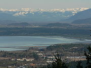
. It is entirely flooded at high tide and at low tide mudflats are exposed. These mud flats are habitat for many species of birds and animals. The bay is very shallow. Near Hat Island the bay is only 12 feet (4 m) deep. Part of the estuary tidal flats are contained by dikes built in order to make farmland out of the mudflats.
The Reserve
The Padilla Bay National Estuarine Research Reserve is an area of 8004 acres (32 km²) of estuary located in Skagit County. The reserve contains the Breazeale Interpretive Center, which features exhibits about the natural history and ecology of the estuary and bay, fish tanks, a hands-on room and a video theater.The site also features classrooms, research facilities, and public access to a beach
Beach
A beach is a geological landform along the shoreline of an ocean, sea, lake or river. It usually consists of loose particles which are often composed of rock, such as sand, gravel, shingle, pebbles or cobblestones...
site. It is a popular location for graduate studies from Western Washington University
Western Washington University
Western Washington University is one of six state-funded, four-year universities of higher education in the U.S. state of Washington. It is located in Bellingham and offers bachelor's and master's degrees.-History:...
and the University of Washington
University of Washington
University of Washington is a public research university, founded in 1861 in Seattle, Washington, United States. The UW is the largest university in the Northwest and the oldest public university on the West Coast. The university has three campuses, with its largest campus in the University...
.
Padilla Bay is a part of the National Estuarine Research Reserve
National Estuarine Research Reserve
The National Estuarine Research Reserve System is a program of the United States government. The program establishes federal-state partnerships under the Coastal Zone Management Act to create a system of estuarine research reserves representative of the various regions and estuarine types in the...
which it was incorporated into in 1980. It is managed by the Washington Department of Ecology
Washington Department of Ecology
The Washington Department of Ecology, or simply, Ecology, is an environmental regulatory agency for the State of Washington. The department administers laws and regulations pertaining to the areas of water quality, water rights and water resources, shoreline management, toxics clean-up, nuclear...
. It has several trails. There is a wheelchair trail to the observation deck as well as a shore trail that is 2.25 miles (3.62 km) long and runs along the top of the dikes.
The research center is located in the Skagit Valley
Skagit Valley
The Skagit Valley lies in the northwestern corner of the state of Washington, USA. Its defining feature is the Skagit River, which snakes through local communities which include the seat of Skagit County, Mount Vernon, as well as Sedro-Woolley, Concrete, Lyman-Hamilton, and Burlington.The local...
of Washington. The nearest town is Anacortes, Washington
Anacortes, Washington
Anacortes is a city in Skagit County, Washington, United States. The name "Anacortes" is a consolidation of the name Anna Curtis, who was the wife of early Fidalgo Island settler Amos Bowman. Anacortes' population was 15,778 at the time of the 2010 census...
about 6 miles (10 km) away.