

Pacific City, Oregon
Encyclopedia
Census-designated place
A census-designated place is a concentration of population identified by the United States Census Bureau for statistical purposes. CDPs are delineated for each decennial census as the statistical counterparts of incorporated places such as cities, towns and villages...
(CDP) and unincorporated community in Tillamook County
Tillamook County, Oregon
Tillamook County is a county located in the U.S. state of Oregon. The county is named for the Tillamook, a Native American tribe who were living in the area in the early 19th century at the time of European American settlement. In 2010, the county's population was 25,250...
, Oregon
Oregon
Oregon is a state in the Pacific Northwest region of the United States. It is located on the Pacific coast, with Washington to the north, California to the south, Nevada on the southeast and Idaho to the east. The Columbia and Snake rivers delineate much of Oregon's northern and eastern...
, United States
United States
The United States of America is a federal constitutional republic comprising fifty states and a federal district...
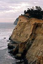
. The population was 1,027 at the 2000 census. Pacific City's main attraction is the Cape Kiwanda State Natural Area
Cape Kiwanda State Natural Area
Cape Kiwanda State Natural Area is located in Pacific City, Oregon, United States. Cape Kiwanda is on the Three Capes Scenic Route, which includes Cape Meares and Cape Lookout. Hiking to the top of Cape Kiwanda allows views of Nestucca Bay to the south and Cape Lookout to the north.A sea stack,...
.
Geography
Pacific City is located at 45.205243°N 123.960475°W.According to the United States Census Bureau
United States Census Bureau
The United States Census Bureau is the government agency that is responsible for the United States Census. It also gathers other national demographic and economic data...
, the CDP has a total area of 3.8 square miles (9.8 km²), of which, 3.7 square miles (9.6 km²) of it is land and 0.1 square mile (0.258998811 km²) of it (2.86%) is water. The area is located 13 feet (4 m) above sea-level.
History
In 1845, Mr. Johnson, a cook on an English ship sailing along the Columbia RiverColumbia River
The Columbia River is the largest river in the Pacific Northwest region of North America. The river rises in the Rocky Mountains of British Columbia, Canada, flows northwest and then south into the U.S. state of Washington, then turns west to form most of the border between Washington and the state...
, deserted and traveled down the Willamette Valley
Willamette Valley
The Willamette Valley is the most populated region in the state of Oregon of the United States. Located in the state's northwest, the region is surrounded by tall mountain ranges to the east, west and south and the valley's floor is broad, flat and fertile because of Ice Age conditions...
. Establishing a land claim in Champoeg
Champoeg, Oregon
Champoeg is a former town in the U.S. state of Oregon. Now a ghost town, it was an important settlement in the Willamette Valley in the early 1840s. It is positioned halfway between Oregon City and Salem and the site of the first provisional government of the Oregon Country...
, he began removing brush and that summer set off a burn to clear debris. The Champoeg Fire got out of control and spread eastward. Unfortunately, the wind then reversed direction and strengthened, blowing the blaze around the previous burn and fanning it into the dry Coast Range, where it burned in the Yamhill basin for weeks, consuming 1500000 acres (6,070.3 km²) of old growth forest - the largest such area destroyed in a single forest fire in the United States. Settlers did not live west of the Coast Range, but the small tribes of Native Americans in the area, already depleted by 80% due to malaria and other epidemics from 1830–1841, were driven from their lands.
The Nestuggas were one such tribe, that had previously been encamped just north of Pacific City near the town of Woods
Woods, Oregon
Woods is an unincorporated community in Tillamook County, Oregon, United States. Woods lies at the intersection of Brooten Road, Resort Drive, and Ferry Road and is just north of Pacific City....
. They had noticed the smoke for several weeks, but were surprised one morning as the bright flames flickered atop the crests of the surrounding hills and rushed down on them. The Nestuggas fled by canoe down the Big Nestucca River to the ocean, and took refuge on the half-mile wide bare sandspit between Nestucca Bay and the ocean. After several weeks the fires were ended by a heavy rain, but the devastation had been complete: The forests were gone, and the game found to be charred crisp or cooked in the water they had sought refuge in.
Nestucca Bay was a rich fishing area, allowing the Nestuggas to survive despite the destruction of game. However, beginning in 1854 settlers began arriving in the Tillamook Valley, and by 1876 Chief Nestugga Bill and the 200 remaining people of the small tribe were relocated to a reservation on the Salmon and Siletz River.
Many early pioneers arrived via seagoing steamers, others arrived from across the mountains. The town of Woods established itself as a depot for the new arrivals and a source of supplies and trade for the settlers. In 1886 the Linewebber and Brown cannery was started to take advantage of the plentiful fish in Nestucca Bay, shipping 12,000 cans of salmon a year and providing an economic basis until 1926 for the region, along with logging and dairy farming. The area also became a "vacation" destination for Oregon Trail pioneers from the midwest, whom had never seen the ocean.
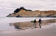
The town gained its modern name of Pacific City in 1909 to avoid confusion with the Washington town of Ocean Park. By 1926, overfishing from gillnetting had left the bay depleted of salmon, so commercial harvesting was stopped and fishermen switched to surf-launched dories; over time due to commercial fishing vessels, the Dory Fleet dwindled and today only a few recreational fishermen keep the tradition alive. Tourism in the 1920s became the mainstay of the economy, lasting until the depression of the 1930s. An airport
Pacific City State Airport
Pacific City State Airport , is a public airport located one mile south of the city of Pacific City in Tillamook County, Oregon, USA.-External links:*...
was built to attract barnstormers and aviators, and other roads and bridges were opened.
Demographics
As of the censusCensus
A census is the procedure of systematically acquiring and recording information about the members of a given population. It is a regularly occurring and official count of a particular population. The term is used mostly in connection with national population and housing censuses; other common...
of 2000, there were 1,027 people, 485 households, and 317 families residing in the CDP. The population density
Population density
Population density is a measurement of population per unit area or unit volume. It is frequently applied to living organisms, and particularly to humans...
was 274.7 people per square mile (106.0/km2). There were 1,090 housing units at an average density of 291.6 per square mile (112.5/km2). The racial makeup of the CDP was 94.16% Caucasian, 1.75% Native American, 0.58% Asian, 2.04% from other races
Race (United States Census)
Race and ethnicity in the United States Census, as defined by the Federal Office of Management and Budget and the United States Census Bureau, are self-identification data items in which residents choose the race or races with which they most closely identify, and indicate whether or not they are...
, and 1.46% from two or more races. Hispanic or Latino of any race were 3.02% of the population.
There were 485 households out of which 13.4% had children under the age of 18 living with them, 54.8% were married couples
Marriage
Marriage is a social union or legal contract between people that creates kinship. It is an institution in which interpersonal relationships, usually intimate and sexual, are acknowledged in a variety of ways, depending on the culture or subculture in which it is found...
living together, 6.6% had a female householder with no husband present, and 34.6% were non-families. 30.1% of all households were made up of individuals and 14.8% had someone living alone who was 65 years of age or older. The average household size was 2.12 and the average family size was 2.55.
In the CDP the population was spread out with 16.1% under the age of 18, 4.0% from 18 to 24, 17.6% from 25 to 44, 35.0% from 45 to 64, and 27.4% who were 65 years of age or older. The median age was 53 years. For every 100 females there were 96.7 males. For every 100 females age 18 and over, there were 94.1 males.
The median income for a household in the CDP was $33,250, and the median income for a family was $55,368. Males had a median income of $26,042 versus $26,250 for females. The per capita income
Per capita income
Per capita income or income per person is a measure of mean income within an economic aggregate, such as a country or city. It is calculated by taking a measure of all sources of income in the aggregate and dividing it by the total population...
for the CDP was $25,819. About 8.4% of families and 7.9% of the population were below the poverty line, including 23.8% of those under age 18 and none of those age 65 or over.
Transportation
Pacific City is located 2.8 miles (4.5 km) from U.S. Route 101U.S. Route 101 in Oregon
In the U.S. state of Oregon, U.S. Route 101, a major north–south U.S. Highway, runs through the state along the coastline near the Pacific Ocean. In Oregon, it runs from the Oregon–California border, south of Brookings, to the Oregon–Washington border on the Columbia River, between Astoria,...
, and is served by the 1,875-foot-long Pacific City State Airport
Pacific City State Airport
Pacific City State Airport , is a public airport located one mile south of the city of Pacific City in Tillamook County, Oregon, USA.-External links:*...
, owned and maintained by Oregon Department of Aviation
Oregon Department of Aviation
The Oregon Department of Aviation is an agency of the government of the U.S. state of Oregon chiefly responsible for matters relating to the continuing development of aviation as part of the state's transportation system, and the safety of its airways...
.
Tillamook County Transportation District
Tillamook County Transportation District
The Tillamook County Transportation District is a provider of local and intercity bus transportation services in Tillamook County, Oregon, United States...
, with two bus stops in Pacific City, offers bus service to Tillamook
Tillamook, Oregon
The city of Tillamook is the county seat of Tillamook County, Oregon, United States. The city is located on the southeast end of Tillamook Bay on the Pacific Ocean. The population was 4,352 at the 2000 census...
.