

Orocopia Mountains
Encyclopedia
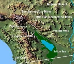
The Orocopia Mountains are located in Riverside County in southern California
, USA, east of the Coachella Valley
, west of the Chuckwalla Mountains
, and south of Interstate 10
in the Colorado Desert
. The range lies in an east-west direction, and is approximately 18 miles long. The Orocopia Mountains are north of and overlooking the Salton Sea
and south of Joshua Tree National Park
, with the Chocolate Mountains
to the southeast and the scenic Mecca Hills
just northwest.
 The area is the Bureau of Land Management
(BLM) designated and managed Orocopia Mountains Wilderness Area. The Orocopia Mountains are in the Colorado Desert
section of the Sonoran Desert
, adjacent to the Lower Colorado River Valley
region. Just to the north is the Mecca Hills Wilderness Area.
with the only California native
palm, Washingtonia filifera
or the California Fan Palm.
passed through the mountains, the first "euroamerican" route to the Colorado River
from Riverside, California
.
over millennia.
The Orocopia Mountains offer considerable geologic variety and was one of the areas used for geologic field training by Caltech Professor of Geology, Leon T. Silver
, for astronauts in preparation for the NASA
Apollo
Moon landing missions.
California
California is a state located on the West Coast of the United States. It is by far the most populous U.S. state, and the third-largest by land area...
, USA, east of the Coachella Valley
Coachella Valley
Coachella Valley is a large valley landform in Southern California. The valley extends for approximately 45 miles in Riverside County southeast from the San Bernardino Mountains to the saltwater Salton Sea, the largest lake in California...
, west of the Chuckwalla Mountains
Chuckwalla Mountains
The Chuckwalla Mountains are a mountain range in the transition zone between the Colorado Desert—Sonoran Desert and the Mojave Desert, climatically and vegetationally, in Riverside County of southern California.-Geography:...
, and south of Interstate 10
Interstate 10
Interstate 10 is the fourth-longest Interstate Highway in the United States, after I-90, I-80, and I-40. It is the southernmost east–west, coast-to-coast Interstate Highway, although I-4 and I-8 are further south. It stretches from the Pacific Ocean at State Route 1 in Santa Monica,...
in the Colorado Desert
Colorado Desert
California's Colorado Desert is a part of the larger Sonoran Desert, which extends across southwest North America. The Colorado Desert region encompasses approximately , reaching from the Mexican border in the south to the higher-elevation Mojave Desert in the north and from the Colorado River in...
. The range lies in an east-west direction, and is approximately 18 miles long. The Orocopia Mountains are north of and overlooking the Salton Sea
Salton Sea
The Salton Sea is a shallow, saline, endorheic rift lake located directly on the San Andreas Fault, predominantly in California's Imperial Valley. The lake occupies the lowest elevations of the Salton Sink in the Colorado Desert of Imperial and Riverside counties in Southern California. Like Death...
and south of Joshua Tree National Park
Joshua Tree National Park
Joshua Tree National Park is located in southeastern California. Declared a U.S. National Park in 1994 when the U.S. Congress passed the California Desert Protection Act , it had previously been a U.S. National Monument since 1936. It is named for the Joshua tree forests native to the park...
, with the Chocolate Mountains
Chocolate Mountains
The Chocolate Mountains of California are located in Imperial County and Riverside County in the Colorado Desert in Southern California. The mountains stretch more than 60 miles in a northwest to southeast direction, and are located east of the Salton Sea and south and west of the Chuckwalla...
to the southeast and the scenic Mecca Hills
Mecca Hills
The Mecca Hills are a low mountain range located in Riverside County, California in southern California, USA, east of the Coachella Valley, west of the Chuckwalla Mountains, and south of Interstate 10 in the Colorado Desert. The range lies in an east-west direction...
just northwest.
Orocopia Mountains Wilderness Area
Bureau of Land Management
The Bureau of Land Management is an agency within the United States Department of the Interior which administers America's public lands, totaling approximately , or one-eighth of the landmass of the country. The BLM also manages of subsurface mineral estate underlying federal, state and private...
(BLM) designated and managed Orocopia Mountains Wilderness Area. The Orocopia Mountains are in the Colorado Desert
Colorado Desert
California's Colorado Desert is a part of the larger Sonoran Desert, which extends across southwest North America. The Colorado Desert region encompasses approximately , reaching from the Mexican border in the south to the higher-elevation Mojave Desert in the north and from the Colorado River in...
section of the Sonoran Desert
Sonoran Desert
The Sonoran Desert is a North American desert which straddles part of the United States-Mexico border and covers large parts of the U.S. states of Arizona and California and the northwest Mexican states of Sonora, Baja California, and Baja California Sur. It is one of the largest and hottest...
, adjacent to the Lower Colorado River Valley
Lower Colorado River Valley
The Lower Colorado River Valley is the river region of the lower Colorado River of the southwestern United States in North America that rises in the Rocky Mountains and has its outlet at the Colorado River Delta in the northern Sea of Cortez in northwestern Mexico, between the states of Baja...
region. Just to the north is the Mecca Hills Wilderness Area.
Flora and fauna
The Wilderness Area includes some remnant natural spring fed oasisOasis
In geography, an oasis or cienega is an isolated area of vegetation in a desert, typically surrounding a spring or similar water source...
with the only California native
California native plants
California native plants are plants that existed in California prior to the arrival of European explorers and colonists in the late 18th century...
palm, Washingtonia filifera
Washingtonia filifera
Washingtonia filifera , with the common names California Fan Palm , Desert Fan Palm, Cotton palm, and Arizona Fan Palm. It is a palm native to southwestern North America between an elevation range of , at seeps, desert bajadas, and springs where underground water is continuously available...
or the California Fan Palm.
History
The Bradshaw TrailBradshaw Trail
The Bradshaw Trail, nicknamed the Gold Road at one time, is an historic overland stage route in Southern California which originally connected San Bernardino, California to gold fields in La Paz, Arizona, some miles north of Ehrenberg...
passed through the mountains, the first "euroamerican" route to the Colorado River
Colorado River
The Colorado River , is a river in the Southwestern United States and northwestern Mexico, approximately long, draining a part of the arid regions on the western slope of the Rocky Mountains. The watershed of the Colorado River covers in parts of seven U.S. states and two Mexican states...
from Riverside, California
Riverside, California
Riverside is a city in Riverside County, California, United States, and the county seat of the eponymous county. Named for its location beside the Santa Ana River, it is the largest city in the Riverside-San Bernardino-Ontario metropolitan area of Southern California, 4th largest inland California...
.
Geology and astronauts
The dramatic and variable terrain was shaped primarily by movements of the adjacent San Andreas FaultSan Andreas Fault
The San Andreas Fault is a continental strike-slip fault that runs a length of roughly through California in the United States. The fault's motion is right-lateral strike-slip...
over millennia.
The Orocopia Mountains offer considerable geologic variety and was one of the areas used for geologic field training by Caltech Professor of Geology, Leon T. Silver
Leon Silver
Leon Theodore "Lee" Silver . Professor of Geology at California Institute of Technology , was an instructor to the Apollo 13, 15, 16, and 17 astronaut crews...
, for astronauts in preparation for the NASA
NASA
The National Aeronautics and Space Administration is the agency of the United States government that is responsible for the nation's civilian space program and for aeronautics and aerospace research...
Apollo
Project Apollo
The Apollo program was the spaceflight effort carried out by the United States' National Aeronautics and Space Administration , that landed the first humans on Earth's Moon. Conceived during the Presidency of Dwight D. Eisenhower, Apollo began in earnest after President John F...
Moon landing missions.
- Apollo 13 Crew Training: September 1969: Lovell, Haise, & Swigert
- Apollo 14 Crew Training: February 1971: Shepard, Roosa, & Mitchell
- Apollo 15 Crew Training: June 1970: Scott, Irwin, & Worden
- Apollo 16 Crew Training: April 1972: Young, Mattingly, & Duke
- Apollo 17 Crew Training: December 1972: Cernan, Evans, & Schmitt