
Oregon Route 332
Encyclopedia
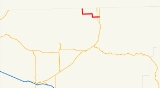
Oregon Route 332 is an Oregon
state highway
running from the Washington state line near Umapine
to OR 11 near Milton-Freewater
. OR 332 is known as the Sunnyside-Umapine Highway No. 332 (see Oregon highways and routes). It is approximately eight miles long and runs east–west, entirely within Umatilla County
.
OR 332 was established in 2003 as part of Oregon's project to assign route numbers to highways that previously were not assigned, and, as of July 2010, was unsigned.
. Near Milton-Freewater, OR 332 crosses OR 339 and proceeds east. Approximately one mile north of Milton-Freewater, OR 332 ends at an intersection with OR 11.
Oregon
Oregon is a state in the Pacific Northwest region of the United States. It is located on the Pacific coast, with Washington to the north, California to the south, Nevada on the southeast and Idaho to the east. The Columbia and Snake rivers delineate much of Oregon's northern and eastern...
state highway
State highway
State highway, state road or state route can refer to one of three related concepts, two of them related to a state or provincial government in a country that is divided into states or provinces :#A...
running from the Washington state line near Umapine
Umapine, Oregon
Umapine is an unincorporated community in Umatilla County, Oregon, United States, two miles from the Oregon-Washington border. It has a population of approximately 300 people. The community is part of the Pendleton–Hermiston Micropolitan Statistical Area...
to OR 11 near Milton-Freewater
Milton-Freewater, Oregon
Milton-Freewater is a city in Umatilla County, Oregon, United States. The city received its current name in 1951 when the neighboring rival cities of Milton and Freewater voted to merge. The population was 6,470 at the 2000 census...
. OR 332 is known as the Sunnyside-Umapine Highway No. 332 (see Oregon highways and routes). It is approximately eight miles long and runs east–west, entirely within Umatilla County
Umatilla County, Oregon
Umatilla County is a county located in the U.S. state of Oregon. It is included in the 8 county definition of Eastern Oregon. The county is named for the Umatilla River. In 2010, its population was 75,889...
.
OR 332 was established in 2003 as part of Oregon's project to assign route numbers to highways that previously were not assigned, and, as of July 2010, was unsigned.
Route description
OR 332 begins at an intersection with State Line Road on the Washington state line two miles (3 km) north of Umapine and heads south and then east toward Milton-Freewater, passing through SunnysideSunnyside, Umatilla County, Oregon
Sunnyside is an unincorporated community in Umatilla County, Oregon, United States. It is located about three miles north of Milton-Freewater, at the intersection of Oregon Route 332, which is also known as the Sunnyside-Umapine Highway, and Oregon Route 339...
. Near Milton-Freewater, OR 332 crosses OR 339 and proceeds east. Approximately one mile north of Milton-Freewater, OR 332 ends at an intersection with OR 11.
Major intersections
| Milepost | City | Intersection |
|---|---|---|
| Approx. 0.00 | Near Umapine Umapine, Oregon Umapine is an unincorporated community in Umatilla County, Oregon, United States, two miles from the Oregon-Washington border. It has a population of approximately 300 people. The community is part of the Pendleton–Hermiston Micropolitan Statistical Area... |
State Line Road at Washington state line (Begin route) |
| 7.15 | Near Milton-Freewater Milton-Freewater, Oregon Milton-Freewater is a city in Umatilla County, Oregon, United States. The city received its current name in 1951 when the neighboring rival cities of Milton and Freewater voted to merge. The population was 6,470 at the 2000 census... |
OR 339 |
| 7.93 | Near Milton-Freewater | OR 11 |