

Opononi
Encyclopedia
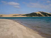
Hokianga
Hokianga is an area surrounding the Hokianga Harbour, also known as The Hokianga River, a long estuarine drowned valley on the west coast in the north of the North Island of New Zealand....
harbour in Northland Region, New Zealand
New Zealand
New Zealand is an island country in the south-western Pacific Ocean comprising two main landmasses and numerous smaller islands. The country is situated some east of Australia across the Tasman Sea, and roughly south of the Pacific island nations of New Caledonia, Fiji, and Tonga...
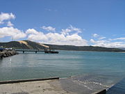
. State Highway 12 runs through Opononi. Omapere lies to the south and Whirinaki
Whirinaki, Northland
Whirinaki is a locality in the south Hokianga, in Northland, New Zealand. The name means "to lean against a support". Highway 12 runs through it. Opononi lies to the south west, and Rawene lies to the north east....
lies to the north east.
The combined population of Opononi and Omapere was 477 in the 2006 Census, a decrease of 117 from 2001.
History
Opo was a dolphin who played with children in the summer of 1955-56. There is a sculpture at her grave.Education
Opononi Area School is a coeducational composite (years 1-15) school with a decile ratingSocio-Economic Decile
Decile, Socio-Economic Decile or Socio-Economic Decile Band is a widely used measure in education in New Zealand used to target funding and support to more needy schools....
of 2 and a roll of 205.